editorial
editorial
entrevista
interview
ágora
agora
tapete
carpet
artigo nomads
nomads paper
projeto
project
expediente
credits
próxima v!rus
next v!rus
issn 2175-974x | ano 2019 year
semestre 01 semester

Por uma relação urbano-rural ambiental na metrópole: didática e ações
Vera Santana Luz é Arquiteta, Doutora em Arquitetura. Professora da Faculdade de Arquitetura e Urbanismo e do Programa de Pós-Graduação em Arquitetura e Urbanismo da Pontifícia Universidade Católica de Campinas. Estuda arquitetura, urbanismo, desenho industrial, ensino, e sustentabilidade.
Antonio Aparecido Fabiano Junior é Arquiteto, Mestre em Arquitetura. Professor da Faculdade de Arquitetura e Urbanismo da Pontifícia Universidade Católica de Campinas e da Universidade Presbiteriana Mackenzie. Estuda projeto de arquitetura e instalações museológicas.
Como citar esse texto: LUZ, V. S.; FABIANO JR., A. A. Por uma relação urbano-rural ambiental na metrópole: didática e ações. V!RUS, São Carlos, n. 18, 2019. [online] Disponível em: <http://www.nomads.usp.br/virus/virus18/?sec=4&item=8&lang=pt>. Acesso em: 13 Jul. 2025.
ARTIGO SUBMETIDO EM 28 DE AGOSTO DE 2018
Resumo
Este artigo apresenta conceituação, objetivos, metodologia e resultados de uma experiência didática realizada em Trabalhos Finais de Graduação durante largo período, na Faculdade de Arquitetura e Urbanismo, da Pontifícia Universidade Católica de Campinas, cuja preocupação se pauta pela indissociação entre ensino-pesquisa-extensão. Através de processos de participação e colaboração comunitária, se articulam premissas de entendimento sobre extensão voluntária e realização de ações concretas em territórios de fragilidade socioespacial destituídos de infraestrutura básica e condições de habitabilidade, às frondes periféricas metropolitanas contíguas às áreas rurais e de preservação ambiental, tensionando as relações homem x homem e homem x natureza em busca de novos paradigmas.
Palavras-Chave: Ensino, Projeto, Fragilidade socioespacial, Ambiente, Participação
1 Em busca de um método acadêmico de colaboração participativa
A premissa fundamental da busca de um método acadêmico de colaboração participativa pressupõe, no nosso entender, a dissolução de muros que separem a atividade acadêmica dos territórios sobre os quais necessariamente deva se debruçar e interagir. Pretende ainda intensificar a hipótese da missão da Universidade como polo concentrador de conhecimento e pulverizar a produção deste conhecimento, de modo que se possa compreender um arco de amplitude capaz de congregar e abrigar os saberes diversos – eruditos ou populares – em seus matizes e suas especificidades, dirigidos para congraçamentos de solidariedade, justiça social e compromisso cívico e ambiental. Nesse sentido, parece oportuno divulgar uma experiência acadêmica, aqui registrada em suas perguntas e tentativas de respostas em ato e discurso, pautada pela definição de arquitetura e urbanismo como função social e, principalmente, conectada a questões de urgência.
2 Questões: o quê, por quê, para quem, onde, como quanto, quando?
Propõe-se apresentar a conceituação, objetivos, metodologia e resultados de uma experiência didática realizada em Trabalhos Finais de Conclusão do Curso de Graduação - TFGs - em Arquitetura e Urbanismo, da Pontifícia Universidade de Campinas, fundamentada a partir de premissas estabelecidas pelos professores orientadores, autores do presente artigo. Sua paulatina revisão e aprimoramento têm se estruturado desde 2012 até a presente data, cuja continuidade organicamente gerou diversos laços de solidariedade e contribuição com as comunidades locais envolvidas, bem como o Projeto de Pesquisa em realização no Programa de Pós-Graduação em Arquitetura e Urbanismo por um dos autores (LUZ, 2018).
O Programa de Curso estabelece a etapa final de formação dos estudantes em duas fases – o Pré-TFG e o TFG –, disciplinas realizadas em dois semestres consecutivos, pressupondo a modulação de um professor orientador para 8 alunos, tendo como conteúdo previsto: na primeira fase, a elaboração de um projeto urbano em grupo; e, na segunda, a realização de Projetos de Arquitetura individuais, subordinados às perspectivas do projeto urbano.
A construção conceitual, metodológica e as razões de ser da orientação escolhida para esses trabalhos se constituíram progressivamente a partir de formulações e de experiências realizadas. Como Projeto Urbano se produzem definições e soluções apresentadas por análises e justificativas, diretrizes e propostas de projeto para as diversas escalas territoriais, quais sejam as de sistemas de diversas naturezas de grande amplitude territorial, nacionais, metropolitanas, regionais e locais. A congruência e articulação entre as escalas de abrangência culminam com o Desenho Urbano de recorte mais pormenorizado, com potência de exemplaridade local, entre 10 e 20 hectares. Se compreendeu a possibilidade de realização, em um mesmo território, do Projeto Urbano aglutinando as duas equipes de alunos mediante co-tutoria simultânea de ambos orientadores, potencializando a capacidade de abrangência e alcance de resultados mais consistentes pela organização de incumbências em subgrupos temáticos e reuniões gerais para discussões e decisões coletivas. Os Projetos de Arquitetura individuais, embora com responsabilidade direta e cotidiana de orientação de um professor, contam com a co-orientação conjugada de ambos com ritmos de necessidade ou aprofundamento para a construção coletiva do conhecimento.
Como formação do arquiteto e urbanista consciente de sua função socialmente necessária, dissolve-se a ideia de autoria como pertencimento individual e reforça-se o necessário compromisso comum, onde o protagonismo do território como personagem principal seja superior ao desejo de destaque ou voluntarismo individual.
Fundamentos e premissas orientadoras da metodologia foram sedimentados gradativamente, ao longo dos anos da atividade, a saber:
PREMISSA 0: Na tríade acadêmica ensino-pesquisa-extensão, pretende-se que estas sejam indissociáveis em todo processo de conhecimento, atividade disciplinar ou ação. Considera-se, portanto, que a etapa final de formação seja a realização de uma experiência abrangente de experimento destas três instâncias conjugadas, onde, embora sendo uma atividade característica de projeto, de modo semelhante não haja dicotomia entre práxis e teoria (LUZ; FABIANO JR., 2014, 2015, 2016, 2017a, 2017b). Logo, se projeto é a elaboração conceitual e prática de propostas de ação realizáveis no mundo, aproximemo-nos, pois, desse mundo, como explicitar-se-á nas premissas subsequentes.
PREMISSA 1: Qualquer atividade, portanto, é considerada projeto, seja investigação, teorização ou proposição prática. Assim, os levantamentos iniciais já são projeto, na medida em que não se excluem, em tempos de trabalho estanques e diferentes, a investigação, o lançamento de hipóteses, teses, pontos de vista ou conclusões. A discussão e a síntese dos sistemas sob responsabilidade de subgrupos se fazem coletivamente, nas leituras, prognósticos e proposições com a finalidade de compreensão do território como um só ser, organismo complexo de sistemas e hierarquias onde afloram tensões, fragilidades e potencialidades. Todos realizam o necessário mergulho in situ, in loco, compreendendo o território - que sabemos estar em crise socioespacial e ambiental - como ente físico e espaço de habitat biológico, do qual fazemos parte como pessoas.
PREMISSA 2: O tema constante e fundamental centra-se na busca de novos paradigmas nas relações urbano/ rural/ ambiental de onde desponta a pergunta “o que é/pode ser cidade?” Cidade como direito (LEFEBVRE, 2016), como convívio, como celebração, vivência e realização, sobrevivência, pacto de solidariedade humana, ente público, polis, civitas. Procura-se a dissolução de dicotomias (cidade/campo, cidade/ambiente, campo/ambiente), dado que tudo - o todo - deve se preservar, sob cotejamento das conflitantes visões do que é desenvolvimento e cujas escolhas afloram da melhor possibilidade de lucidez sobre o desequilíbrio de meios e modos da civilização atual (DAVIS, 2006; GEORGESCU-ROEGEN, 2012; MARQUES, 2016).
PREMISSA 3: Elenca-se como território, necessariamente, franjas metropolitanas de exclusão com fragilidade socioespacial, em São Paulo, onde, simultaneamente, haja infraestrutura de impacto regional ou metropolitano - como a presença do Rodoanel, rodovias, ferrovias, represas de abastecimento, aterros sanitários, aeroportos -, cujas tensões atuem direta ou indiretamente a nível local, com o paradoxo evidente de sua escassez. Advém desta eleição a reflexão sobre a definição de cidade como direito não alcançado. As condicionantes mínimas amparadas pelo direito constitucional - qualidade de moradia não restrita à habitação, mas incluindo infraestrutura, equipamentos, serviços, espaço público e meio ambiente compreendendo-o como habitat -, somam-se à investigação da oportunidade de revisão do entendimento de franjas metropolitanas e seus interstícios urbanos do ponto de vista rural (ARANTES; MARICATO; VAINER, 2000; CALDEIRA, 2000; MARICATO, 2015; ROLNIK, 2007; LUZ; FABIANO JR., 2014, 2015, 2016, 2017a, 2017b).
PREMISSA 4: Todo o desenvolvimento dos trabalhos se pauta pela extensão voluntária da equipe, no convívio e troca de conhecimentos e participação comunitária, representada pelas lideranças locais, desde a apreensão de demandas até as proposições finais, entendendo o território como sujeito e não objeto de estudo.
PREMISSA 5: Ações reais locais são efetivadas pela equipe acadêmica desde a microescala, e de diversas naturezas, como trabalho colaborativo e voluntário, resultando na constituição de redes acadêmicas, na participação em fóruns locais, junto a instâncias legais, na realização de orientações de pesquisas de iniciação científica aplicáveis (LUZ; SILVA, 2018) até a construção colaborativa de um forro térmico em galpão de uma escola municipal (LUZ; FABIANO JR., 2017a).
3 O método do discurso que pretende virar ato
Os sistemas que constituem a investigação e análise territorial e a construção paulatina do entendimento do território como um todo vão no sentido de produzir diagnósticos e prognósticos, que tratam de:
+ Geomorfologia – topografia e hidrografia, vegetação;
+ Sistemas de transportes - rodoviários, ferroviários, metroviários, hidroviários e lacustres, aeroviários, cicloviários, alternativas de transporte leve, de pedestres, por ônibus, estrutura viária, de mobilidade individual;
+ Infraestrutura – energia, água, saneamento de efluentes, resíduos sólidos, drenagem, comunicações, gás;
+ Tecido e vazios urbanos – características morfológicas, sociais e ambientais;
+ Uso e ocupação real do solo – habitação, comércio, indústria, serviços;
+ Equipamentos públicos e privados - de educação, saúde, esportes, cultura, lazer;
+ Sistemas de espaços públicos livres e mobiliário urbano;
+ População – características socioeconômicas, origens, costumes, organização comunitária, lideranças, laços de autonomia e pertencimento, índice de vulnerabilidade social, questões de regularização fundiária, posse, propriedade, exclusão;
+ Histórico e contextualização regional e local;
+ Marcos referenciais – por escala, uso, apropriação cultural; e
+ Legislação – urbana: Plano Diretor, Lei de Uso e Ocupação do Solo, Leis ambientais nos níveis federal, estadual e municipal.
A discussão dos aspectos sistemáticos e da complexidade do território gera o entendimento de potencialidades e fragilidades, as quais conduzem a diretrizes metropolitanas, regionais e locais que reverberam nas diferentes escalas de abrangência e que se materializam em um Projeto Urbano. Deste projeto aflora a hipótese de áreas de exemplaridade, sendo que uma delas, que tenha entre 10 e 20 hectares e seja considerada representativa, é pormenorizada em Desenho Urbano, possibilitando o necessário aprofundamento em escala aproximada. Inicialmente, para o Desenho Urbano desta parcela, investigam-se suas condicionantes fundamentais, delimitam-se seu perímetro de intervenção e a área de influência direta, de modo que este recorte urbano jamais tenha uma forma geométrica abstrata sobreposta ao local. As decisões de projeto neste recorte são continuamente balizadas pela pressão das instâncias regionais e das decisões de Projeto Urbano já constituídas, bem como suas especificidades internas e áreas de sombreamento do entorno imediato ao recorte, de influência direta e indireta.
Projetos de Arquitetura sob responsabilidade individual dos alunos são desenvolvidos em atelier comum, onde a constante troca de ideias abrange aspectos relativos ao locus de intervenção, investigações, ensaios e determinações temáticas, programáticas, morfológicas, de escala e implantação, interfaces comuns entre os projetos, aspectos materiais, estruturais e técnicos e a potência em constituir referência de qualidade espacial, de uso, autonomia local e apropriação comunitária. Os Projetos de Arquitetura são, desse modo, compromissados e inevitavelmente condicionados às decisões do Projeto Urbano e sua configuração. Compreende-se, portanto, que a arquitetura é constitutiva da cidade e a ela subordinada com coerências recíprocas.
Os Projetos de Arquitetura não estarão necessariamente na área do recorte de Desenho Urbano, ou na região do Projeto Urbano, podendo mesmo se situar em território amplo, pois, dependendo de sua razão de ser ou abrangência, considera-se que a cidade possa e deva ter ligações a longa distância capazes de reverberação e contribuição mútua. Os Projetos de Arquitetura iniciam-se pela escolha de um lugar e tema amplo, que, paulatinamente, pode se configurar com programas definidos ou abertos, bem como com espaços sem programa a serem apropriados pela comunidade. A escala destas arquiteturas pode variar desde a microintervenção e a escolha de morfologia, técnicas e materiais é realizada a partir de demandas e potencialidades locais, como ações solidárias de fortalecimento comunitário, pertencimento, colaboração, capacitação, geração de cultura ou renda, a partir de estratégias de economia solidária.
A escolha das frondes urbanas contíguas a regiões com atividades ou potencialidades rurais e áreas ambientais de proteção coloca, inevitavelmente, a questão da cidade não alcançada, pelas condições de fragilidade socioespacial, degradação ambiental e ou ausência de infraestrutura, de mobilidade, de equipamentos e de espaços públicos de qualidade. Na maioria das vezes, despontam alternativas de urgência e mantém-se a pergunta incômoda dos porquês dessa condição planetária em que nos encontramos todos, visto que não existe cidade alguma no mundo que tenha alcançado sustentabilidade, justiça social e equilíbrio ambiental plenos e que nossas cidades brasileiras têm atingido níveis de desigualdade espantosos (GEORGES; MAIA, 2017).
Na fase intermediária de elaboração dos Projetos de Arquitetura, busca-se convidar um arquiteto de experiência consolidada para a realização de uma oficina de trabalho durante o período de um dia de aula, onde os resultados do Projeto Urbano e dos Projetos de Arquitetura em desenvolvimento são discutidos com o convidado, que o submete a críticas, ensaios e sugestões.
A constituição de um método participativo amadureceu para a necessária realização de ações reais, em escalas variadas, envolvendo os professores orientadores e os alunos, como responsabilidade voluntária extra-acadêmica, com as lideranças, representações e grupos comunitários locais, suas demandas e desejos. Após o término do trabalho acadêmico, mantém-se o vínculo de cooperação e responsabilidade mútua com os professores e, por vezes, dos ex-alunos, em uma relação constante, de colaboração realizável no aqui-e-agora ou no vir-a-ser, para fortalecimento de cidadania, identidade, direitos e qualificação do espaço público.
4 Resultados: o que temos aqui e agora?
No decorrer dos anos, o aperfeiçoamento e a consolidação da metodologia se estabeleceram no envolvimento com os diversos territórios de fragilidade socioespacial, carência de infraestrutura básica, mobilidade, equipamentos e serviços públicos, problemas de regularização fundiária. São sempre franjas extremas urbanas, contíguas a áreas ambientais e de potencialidade rural do município de São Paulo, com infraestrutura metropolitana presente, tais como:
+ A região extremo norte, próxima ao trecho norte do Rodoanel Metropolitano e às frondes da Serra da Cantareira;
+ Dois setores do distrito de Marsilac, extremo sul, cortado por ramal ferroviário da antiga Sorocabana que une Mairinque a Santos, com características de adensamento esparso, nos limites da Serra do Mar, com atividades rurais e abrigando tribos tupi-guarani;
+ O distrito de Perus, junto às Rodovias Anhanguera e Bandeirantes e à articulação dos trechos oeste e norte do Rodoanel Metropolitano, com a presença da antiga ferrovia Santos-Jundiaí, o imenso aterro sanitário Bandeirantes (recém desativado), às frondes da Serra da Cantareira, cujas escarpas próximas são submetidas à extração de granito e que possui aldeamento tupi-guarani nas vertentes do Pico do Jaraguá;
+ Dois setores do Fundão do Jardim ngela, totalmente imerso na área de proteção dos mananciais sul, contribuinte da Represa Guarapiranga, cortados pela estrada M’Boi-Mirim, com relativa proximidade aos trechos Oeste e Sul do Rodoanel e contendo parcela do mesmo ramal da antiga ferrovia Sorocabana.
Está em curso o trabalho no distrito de Vila Bela, extremo leste de São Paulo, próximo ao Parque do Carmo, da Avenida Jacu-Pêssego, do trecho leste do Rodoanel Metropolitano, cortado por ribeirões afluentes do Rio Aricanduva, afluente do Tietê e contíguo a remanescente de cinturão rural. Todas se caracterizam por forte presença de organização comunitária e lideranças com lucidez política sobre direitos e responsabilidades. Abaixo, a Figura 1 localiza esses territórios:
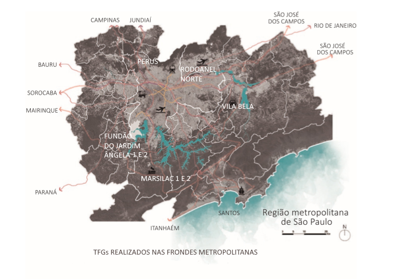
Fig. 1: Territórios de TFGs realizados. Fonte: Geosampa (PMSP) trabalhada pelos autores. Acervo coletivo da equipe de trabalho, 2017.
As imagens relativas aos trabalhos são consideradas de autoria coletiva e constituem acervo também coletivo e disponibilizável para todas as equipes integrantes para divulgação e publicações. Para efeito de exemplaridade vamos apresentar os trabalhos realizados durante o ano de 2017, no Fundão do Jardim ngela, bairro Vera Cruz, que confina com a margem oeste da Represa Guarapiranga, cuja localização é apresentada na Figura 2. Os processos de levantamento, análises, diagnósticos, prognósticos e diretrizes conduziram ao entendimento do território e constituíram um arcabouço fundamental para as decisões de projeto. Alguns destes produtos são ilustrados nas Figuras 3 a 6, a seguir.
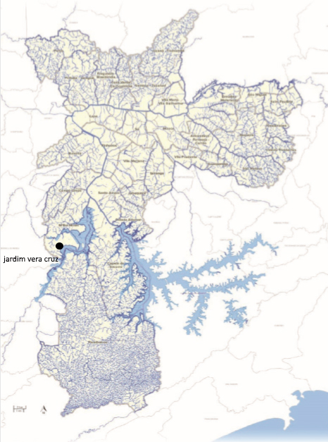
Fig. 2: Sistema hídrico de São Paulo e localização do Jardim Vera Cruz, Fundão do Jardim ngela. Fonte: Geosampa (PMSP) trabalhada pelos autores. Acervo coletivo da equipe de trabalho, 2017.
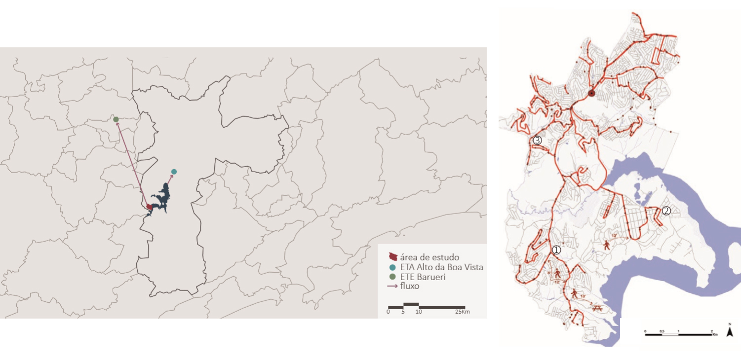
Fig. 3: Jardim Vera Cruz e localização da ETA Alto da Boa Vista e ETE Barueri. Trajetos e tempos de percurso de ônibus até equipamentos regionais. Fonte: Geosampa (PMSP) trabalhada pelos autores. Acervo coletivo da equipe de trabalho, 2017.
Fig. 4: Esquemas de interpretação da legislação. Fonte: Autoria coletiva. Acervo coletivo da equipe de trabalho, 2017.
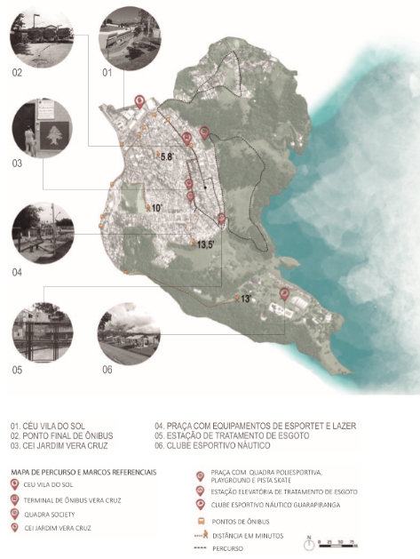
Fig. 5: Marcos referenciais. Fonte: Geosampa (PMSP) trabalhada pelos autores. Acervo coletivo da equipe de trabalho, 2017.
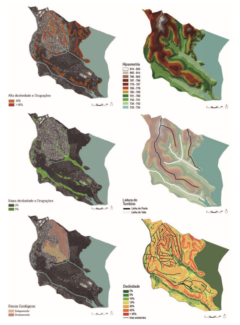
Fig. 6: Relação ocupações e declividade. Hipsometria. Linhas de festo e vale. Locais de risco geológico. Isodeclividades. Fonte: Geosampa (PMSP) trabalhada pelos autores. Acervo coletivo da equipe de trabalho, 2017.
Dada a relação conflitante de dupla urgência detectada na região - a urgência por moradia e a urgência de preservação da área de mananciais -, pautou-se como diretriz ambiental o reconhecimento de uma “linha de pressão” entre o tecido urbanizado e orla da represa, onde se manteve uma faixa de preservação restrita e “guardiões” pontuais em locais estratégicos, constituídos por equipamentos com usos adequados. Entre o tecido urbano e esta orla protegida, glebas de reconstituição da Mata Atlântica, agricultura orgânica ou agroflorestais teriam permissão de uso sem direito de propriedade, em baixíssima densidade e seriam realocadas ocupações cuja mancha urbana fosse considerada área de risco ou de prejuízo ambiental, conforme Figura 7.
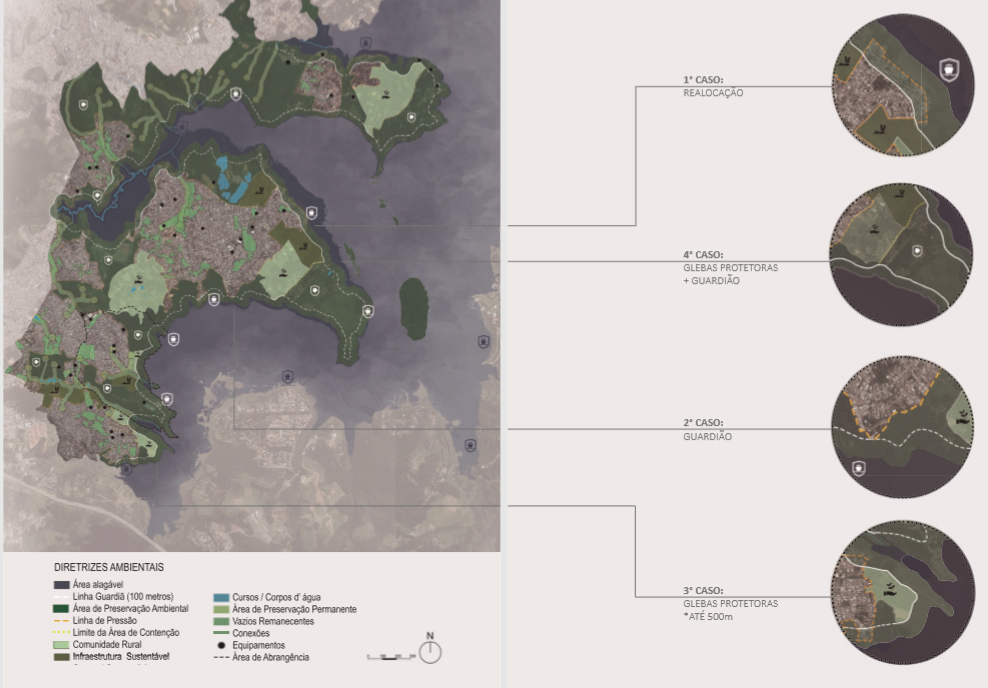
Fig. 7: Diretrizes Ambientais. Fonte: Geosampa (PMSP) trabalhada pelos autores. Acervo coletivo da equipe de trabalho, 2017.
Dada a condição precária de mobilidade, cuja única via arterial é a estrada do M’Boi Mirim, estreita e com poucas faixas, preconizou-se a estruturação de modais de caráter regional e local. Esta estrada passou a compartilhar o sistema em leito central de Veículo Leve sobre Trilhos - VLT -, suspenso ou no nível do solo, conforme características de cada trecho. As estações “pediriam licença” a lotes fronteiros em um acordo de uso e ocupação compensatórios, compartilhando escadas e elevadores públicos que também proporcionariam a travessia da via. Foram estabelecidas possibilidades de ampliação e conexões metropolitanas de modais metroviários, rodoviários e ferroviários, para cargas e passageiros, cuja articulação se deu através da implantação de um ferroanel metropolitano, lindeiro à via externa dos trechos do Rodoanel oeste, sul e leste. Também optou-se pela adoção do sistema Metrópole Fluvial, importante estudo de referência coordenado pelo arq. Alexandre Delijaicov (GRUPO, 2011), para o qual se propuseram trajetos e portos alternativos de diferentes escalas na represa Guarapiranga. Bolsões de âmbito local para trajetos de ônibus e uma pluralidade de sistemas leves foram preconizados, visando à liberação das vias estreitas, características do bairro, para prioridade de permanência e uso de pedestres. As diretrizes de transporte e mobilidade são apresentadas resumidamente nas Figuras 8 a 11, a seguir:
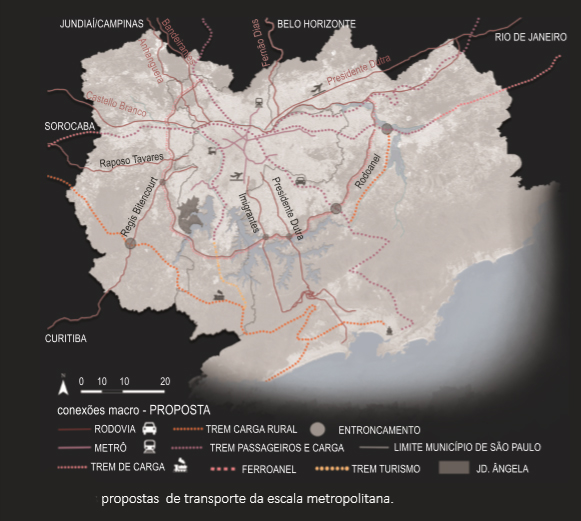
Fig. 8: Sistema multimodal de mobilidade regional. Fonte: Geosampa (PMSP) trabalhada pelos autores. Acervo coletivo da equipe de trabalho, 2017.
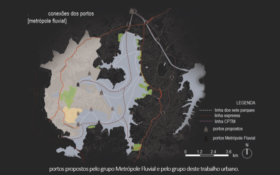
Fig. 9: Sistema de transporte fluvial na Represa Guarapiranga. Fonte: Geosampa (PMSP) trabalhada pelos autores. Acervo coletivo da equipe de trabalho, 2017.
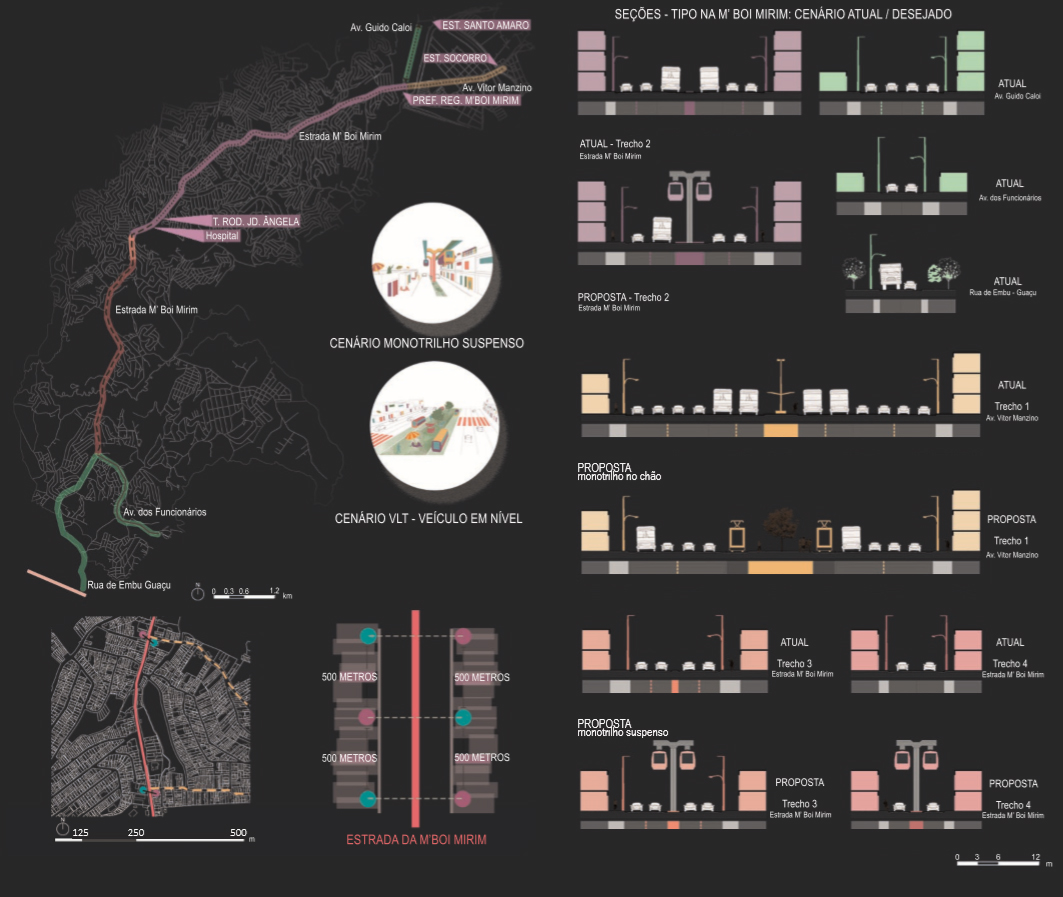
Fig. 10: VLT estrutural. Fonte: Geosampa (PMSP) trabalhada pelos autores. Acervo coletivo da equipe de trabalho, 2017.
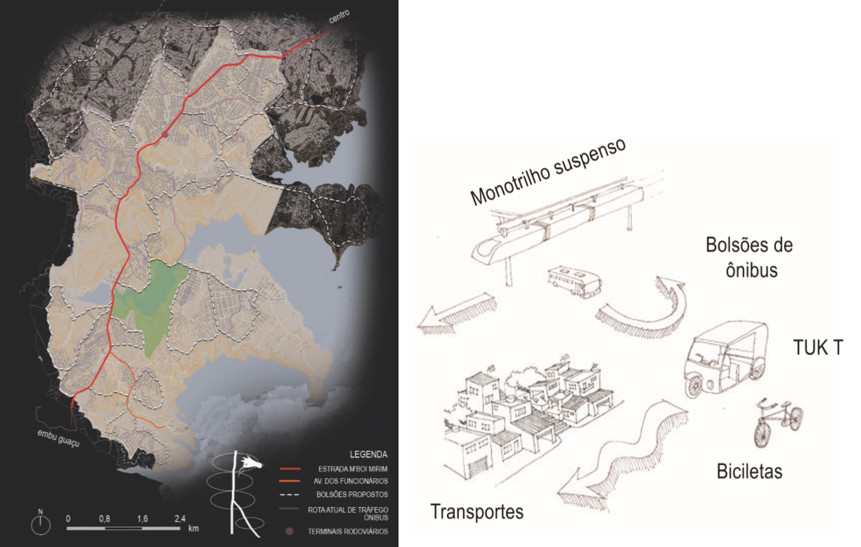
Fig. 11: Bolsões de ônibus. Conjunto de alternativas de transporte. Fonte: Geosampa (PMSP) trabalhada pelos autores. Acervo coletivo da equipe de trabalho, 2017.
Considerando a escassez de equipamentos públicos, foi proposta uma rede mediante a sistematização das necessidades e áreas de abrangência (Figura 12).
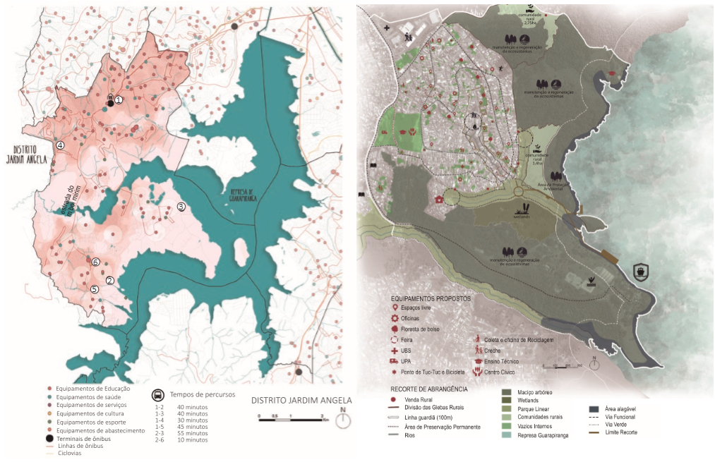
Fig. 12: Equipamentos públicos existentes e propostos. Fonte: Geosampa (PMSP) trabalhada pelos autores. Acervo coletivo da equipe de trabalho, 2017.
Dada a estruturação da mobilidade, a leitura do tecido urbano conduziu ao entendimento de que o pacto de habitabilidade na área de mananciais deveria ser pautado pelo adensamento zero, mantendo-se todos os vazios remanescentes para renaturalização e drenagem, mediante Florestas de bolso™ (CARDIM, 2016), agricultura urbana intersticial e espaços livres ou de pequena taxa de ocupação, para uso comunitário. Foram catalogadas espécies nativas de alto e médio porte, orientando a renaturalização, observadas as cores das floradas e a proteção da fauna, cujos estudos são visualizáveis nas Figuras 13 a 15, a seguir.
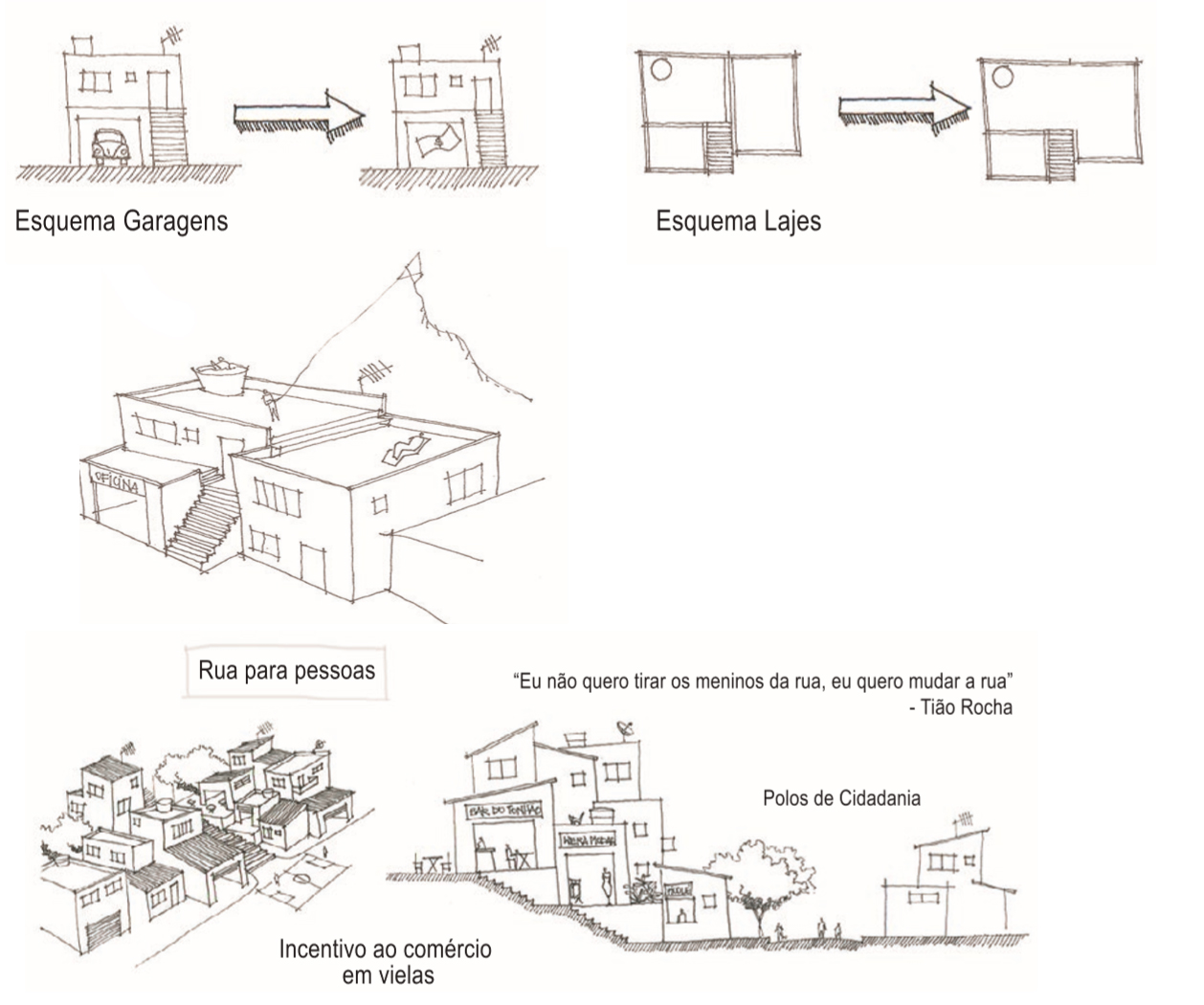
Fig. 13: Espaços públicos de qualidade. Fonte: Autoria coletiva. Acervo da equipe de trabalho, 2017.
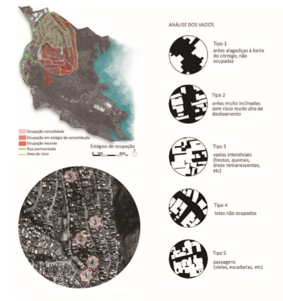
Fig. 14: Vazios urbanos e espaços públicos de qualidade. Fonte: Geosampa (PMSP) trabalhada pelos autores. Acervo coletivo da equipe de trabalho, 2017.
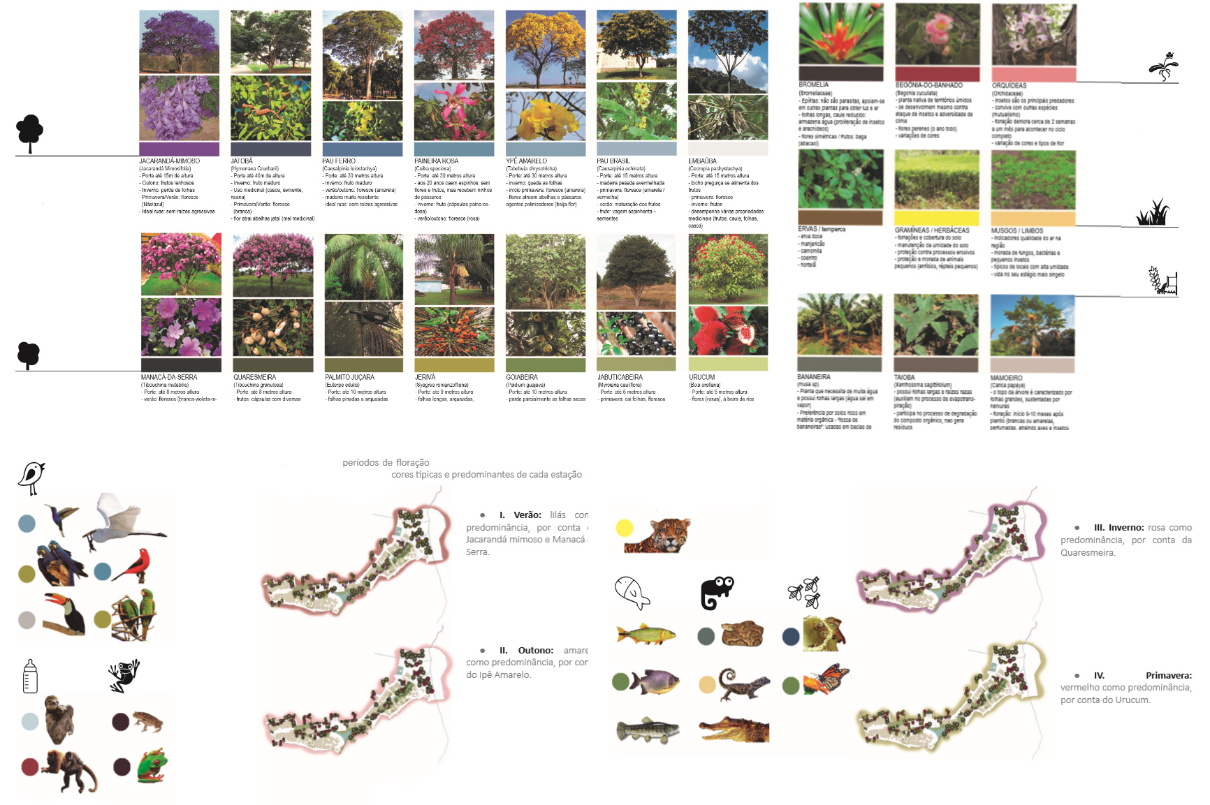
Fig. 15: Espécies da flora nativa. Fonte: Autoria coletiva. Acervo da equipe de trabalho, 2017.
Seguindo estas diretrizes e a partir da matriz de ocupação informal prevalente e dos altos índices de vulnerabilidade social, considerou-se como preceito legal a posse coletiva, considerando que tudo o que toque o ar seja público, a saber, as fachadas, lajes e mesmo garagens obsoletas, para uso comunitário e atividades de capacitação, geradoras de renda por sistemas de economia solidária.
O Desenho Urbano do recorte pormenorizado aprofundou as diretrizes mediante levantamento casa-a-casa (conforme Figuras 16 e 17) e ensaios projetuais, visando, de acordo com as potencialidades encontradas, a constituição de uma exemplaridade de habitar possível em áreas de proteção, com infraestrutura de baixo impacto e escala, suprimento de equipamentos e qualificação do espaço público e da paisagem como instrumento de cidadania, fortalecimento de pertencimento e laços comunitários.
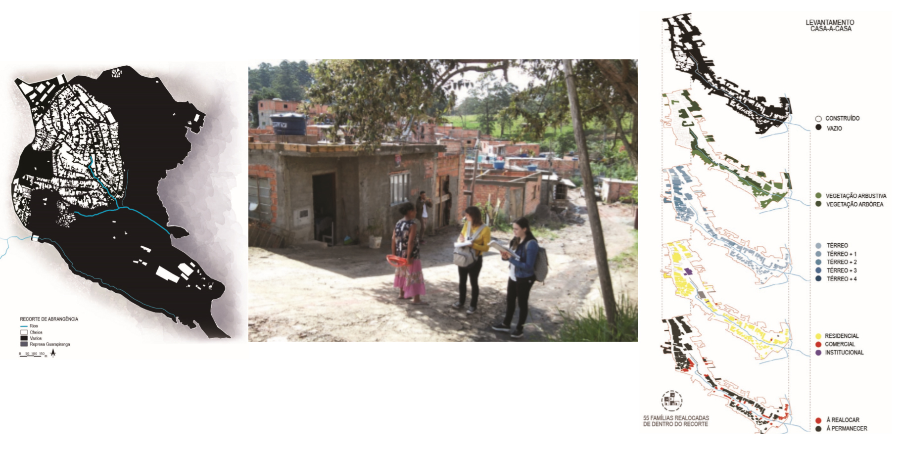
Fig. 16: Bairro. Levantamento casa-a-casa. Fonte: Autoria coletiva. Acervo da equipe de trabalho, 2017.
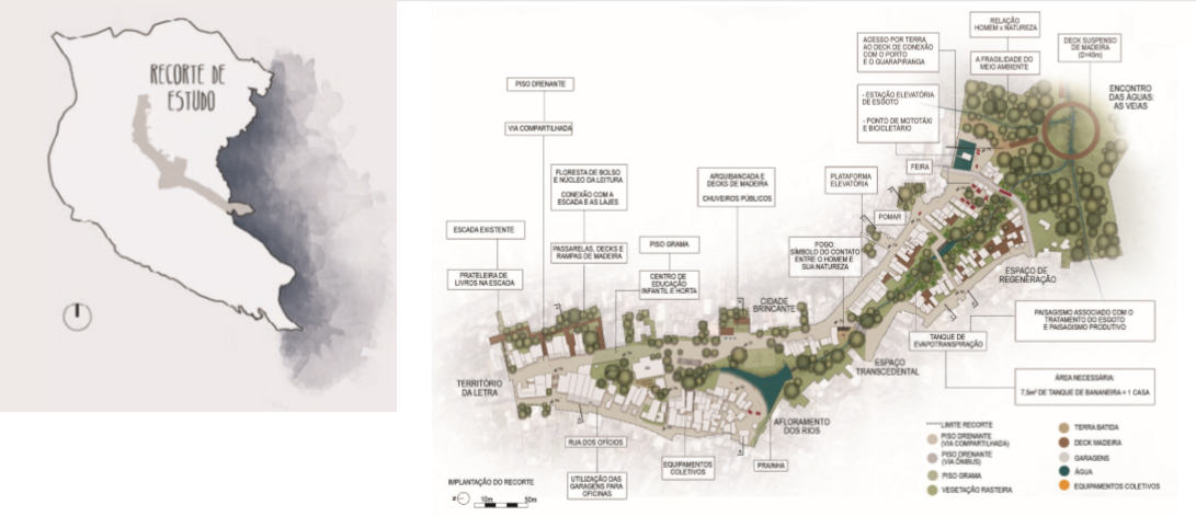
Fig. 17: Desenho Urbano. Fonte: Autoria coletiva. Acervo da equipe de trabalho, 2017.
Foram definidos trechos característicos, norteadores de usos, os quais foram denominados “cidade brincante” – setor central próximo a escola infantil -, “território da letra” - como apoio às atividades culturais - e “espaço de regeneração” – em situação de extrema precariedade, onde foram propostos sistemas de infraestrutura de saneamento por biorremediação, sistemas de reaproveitamento de resíduos recicláveis e usos comunitários de atividades costumeiramente privadas emergenciais, como sanitários, chuveiros, lavanderias comunitárias. A Figura 18 apresenta ilustrações da paisagem pretendida. As Figuras 18 a 22 apresentam estudos das relações de paisagem, infraestrutura e equipamentos.
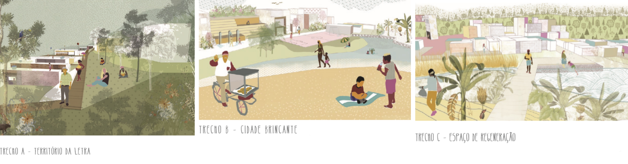
Fig. 18: Setores do Desenho Urbano. Fonte: Autoria coletiva. Acervo da equipe de trabalho, 2017.
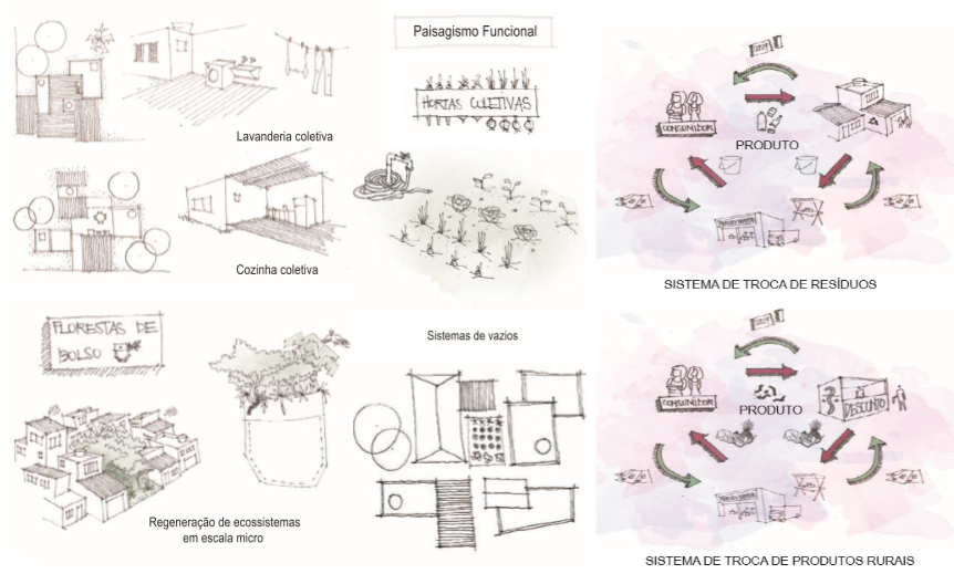
Fig. 19: Estudos de paisagem e infraestrutura: trocas. Fonte: Autoria coletiva. Acervo da equipe de trabalho, 2017.
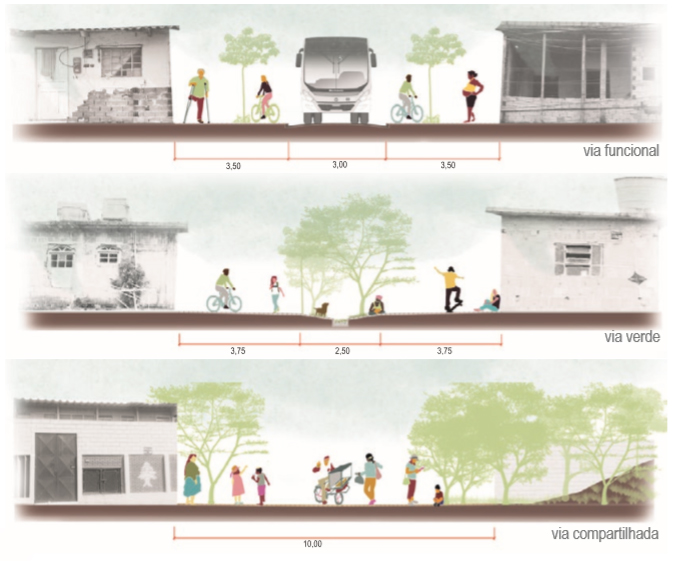
Fig. 20: Vias do Recorte de Desenho Urbano. Fonte: Autoria coletiva. Acervo da equipe de trabalho, 2017.
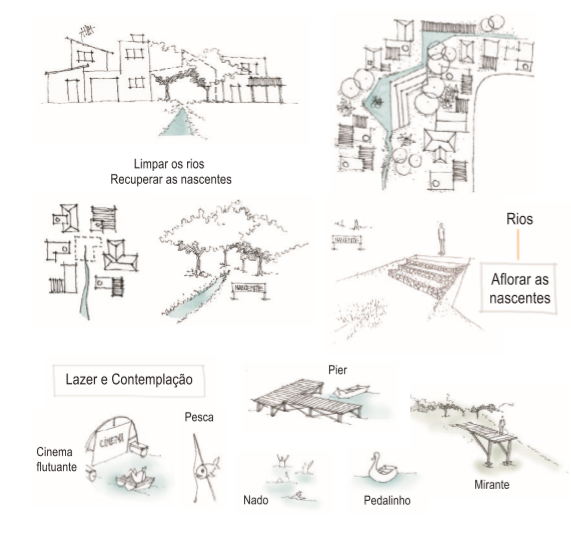
Fig. 21: Estudos de paisagem e infraestrutura: drenagem. Fonte: Autoria coletiva. Acervo da equipe de trabalho, 2017.
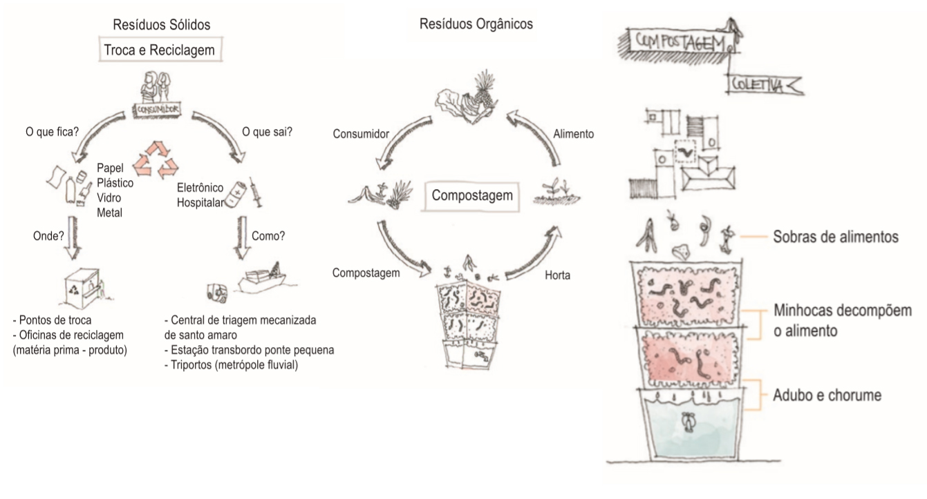
Fig. 22: Estudos de paisagem e infraestrutura: resíduos sólidos. Fonte: Autoria coletiva. Acervo da equipe de trabalho, 2017.
O território configurado pelo Projeto Urbano ensejou 16 Projetos de Arquitetura, cujas localizações, implantações no tecido, temas, escalas, programas, morfologias e constructos se pautaram por reforçar as premissas e ações já estabelecidas (Figura 23).
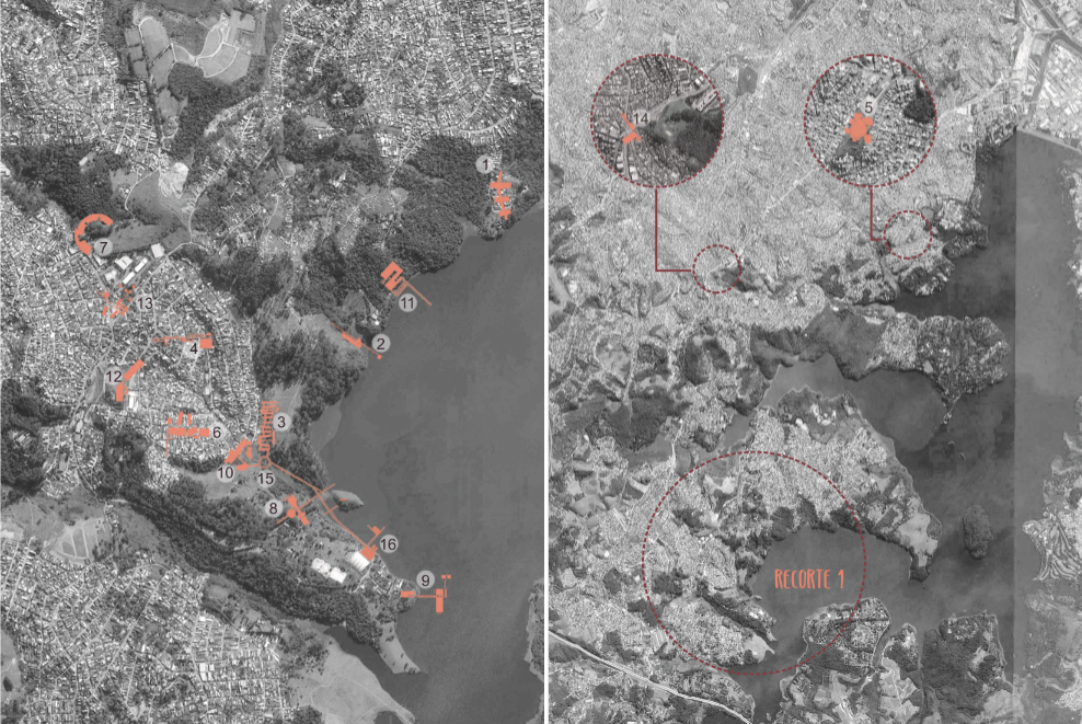
Fig. 23: Localização dos Projetos de Arquitetura. Fonte: googlemaps trabalhada pelos autores. Autoria coletiva. Acervo da equipe de trabalho, 2017. Disponível em: https://bit.ly/2T5aYFl. Acesso em: 10 Jun. 2016.
O desenvolvimento associado dos projetos resultou em soluções particulares e comuns e articulações, seja de implantação e correspondência temática, seja de tipologias constituídas por técnicas e detalhamentos, cujo desdobramento mais recente é a realização de Pesquisa de sistematização de técnicas aplicáveis a territórios de fragilidade socioespacial e ambiental, em curso (LUZ, 2018). Todo o conjunto de trabalhos realizados durante os vários anos pelas equipes é considerado coletivo, como processo e como acervo, cuja disponibilização se dá a todos os co-autores e especialmente às comunidades, como colaboração e instrumento de luta por direitos. Para tanto, agradecemos a solidariedade dos líderes representativos e de suas comunidades, como Maria Cirillo (Marsilac), Soró (Perus), Norberto Martins, Shirlei do Carmo, Maria dos Anjos, Silvia Tavares (Fundão do Jardim ngela: Vila Calu, Jardim Vera Cruz), Marli Silva, Edilene Silva (Vila Bela) e as pessoas públicas que contribuíram para este estreitamento como Helena Singer, Adriano Diogo, Juliana Cardoso e Chaia Schainer.
Estes Projetos de Arquitetura realizados no território do Fundão do Jardim ngela, Jardim Vera Cruz, abrangem compromissos territoriais, cuja autoria, como salientado, configura parte indissociável do trabalho coletivo e comunitário, tanto para o conjunto de autores como para sua disponibilização e se pautam pelos seguintes compromissos territoriais estabelecidos conforme premissas do Projeto Urbano: Guardiões da Mata, Guardiões da Represa, Guardiões da Linha de Pressão Urbano/Rural/Ambiental, Qualificadores do Espaço Público no Tecido Urbano, Qualificadores Metropolitanos, Qualificadores e Articuladores Ambientais/Rurais/Urbanos. O quadro a seguir resume dados gerais, compromissos territoriais e responsabilidade direta de autoria:
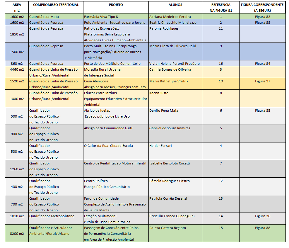
Quadro 1: Quadro resumo dos 16 Projetos de Arquitetura com dados gerais, compromissos territoriais e responsabilidade direta de autoria. Fonte: Realização dos autores. Acervo da equipe de trabalho, 2018.
Seguem imagens de alguns destes Projetos de Arquitetura (Figuras 24 a 30):
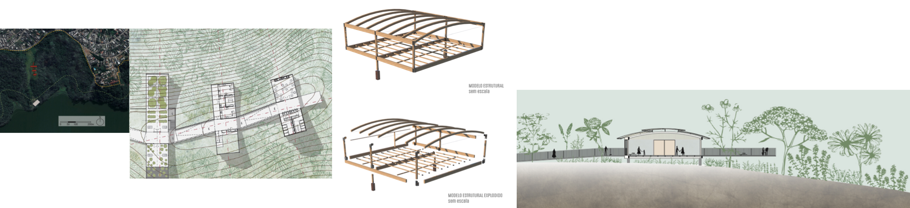
Fig. 24: Farmácia Viva Tipo 3. Fonte: Adriana M. Pereira. Acervo da equipe de trabalho, 2017.
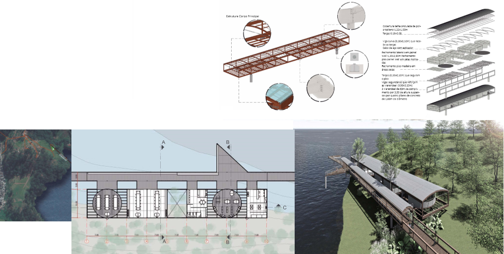
Fig. 25: Polo Ambiental Educativo para Jovens. Fonte: Beatriz C. Michelazzo. Acervo da equipe de trabalho, 2017.
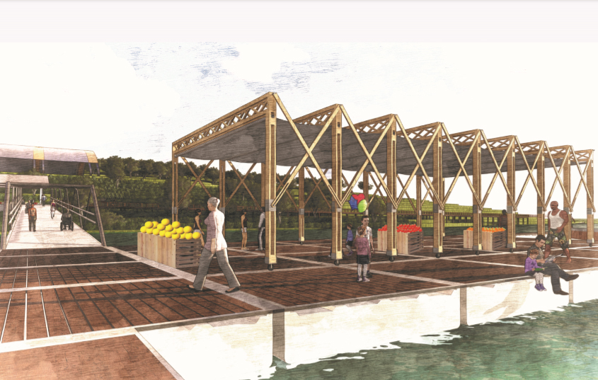
Fig. 26: Porto de Uso Múltiplo Comunitário. Fonte: Vivian H. P. Procópio. Acervo da equipe de trabalho, 2017.
Fig. 27: Abrigo de Ideias: Espaço público de livre uso. Fonte: Danilo P. Maia. Acervo da equipe de trabalho, 2017.
Fig. 28: Estação Multimodal e Polo de Usos Comunitários. Fonte: Priscilla F. Guadaguini. Acervo da equipe de trabalho, 2017.
Fig. 29: Casa Atemporal – Abrigo para idosos, crianças sem teto. Fonte: Maria K. Vrolijk. Acervo da equipe de trabalho, 2017.
Fig. 30: Passagem de Conexão entre Polos de Permanência Comunitária em Área de Proteção Ambiental. Fonte: Raissa G. Begiato. Acervo da equipe de trabalho, 2017.
5 Projeto+participação: dúvidas e certezas de método e amplitude
Desde 2012, as colaborações acadêmicas e comunitárias levaram, no conjunto de trabalhos e seus desdobramentos, a uma solidez de princípios, objetivos e fins e a um acervo que inicia sua divulgação e continuidade (Figuras 31 a 35). O conjunto de ações reais nos territórios aponta para sua intensificação e busca por contribuir, com projetos completos efetivos realizáveis em participações colaborativas publicáveis, como recentemente na XI Bienal de Arquitetura de São Paulo (IAB/SP, 2017).
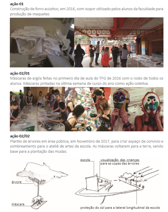
Fig. 31: Construção de forro acústico no galpão da EMEI Chácara Sonho Azul, com sobras de isopor arrecadadas na Faculdade, oriundas de maquetes. Realização de máscaras de argila faciais e sua pintura. Plantio de árvores em terreno público conquistado para ampliação de área de estudos ambientais da EMEI, na XI Bienal de Arquitetura, evento Revitavilla II, cujas máscaras serviram de suporte simbólico ‘enterrando nossos rostos no chão local’. Fonte: Autoria coletiva. Acervo da equipe de trabalho, 2017.
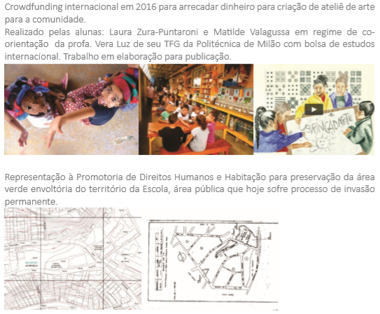
Fig. 32: Crowdfunding realizado em colaboração com alunas intercambistas do Politécnico de Milão em co-tutoria com um dos orientadores, para aperfeiçoamento do atelier arte-educação da EMEI Chácara Sonho Azul. Representação ao Ministério Público contra invasão clandestina de área pública contígua à EMEI. Fonte: Autoria coletiva. Acervo da equipe de trabalho, 2017.
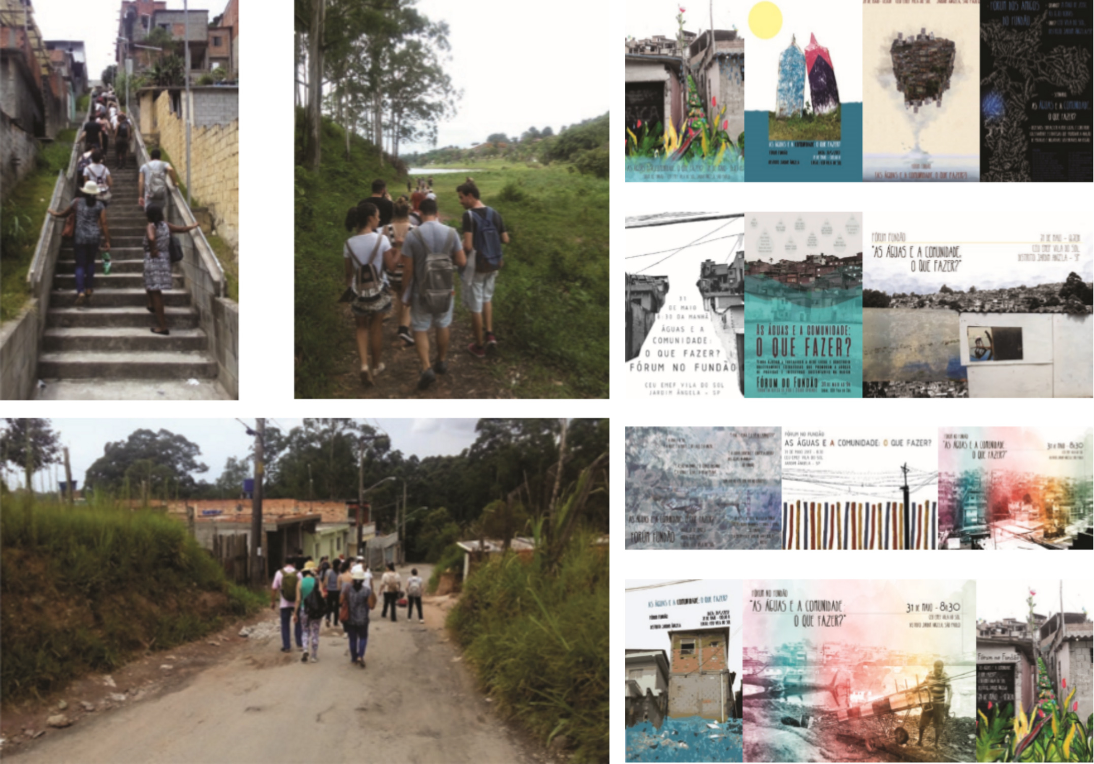
Fig. 33: Visita ao território e Concurso de cartazes do Fórum de Amigos do Fundão: “As Águas e a Comunidade: o Que Fazer?”. Fonte: Autoria coletiva. Acervo da equipe de trabalho, 2017.
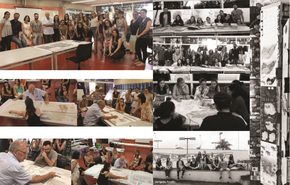
Fig. 34: Oficina de projetos com o arquiteto Marcos Acayaba e Equipe. Fonte: Autoria coletiva. Acervo da equipe de trabalho, 2017.
Fig. 35: Lideranças comunitárias Shirlei do Carmo e Norberto Martins em apresentação acadêmica de trabalhos. Fonte: Autoria coletiva. Acervo da equipe de trabalho, 2017.
6 Continuidades: pontos finais, de exclamação, interrogação, reticências
Busca-se, atualmente, gerar aproximações e trocas com experiências correspondentes, conforme resultados obtidos nas diversas edições do trabalho ao longo dos anos, motivo pelo qual temos realizado sua constante publicação.
Como desdobramento orgânico, estão sendo realizados dois projetos. O primeiro é um Projeto de Pesquisa em Pós-Graduação em Arquitetura e Urbanismo para constituição de Cartilha de sistemas construtivos para edificações e infraestruturas de baixo impacto ambiental, de pequena e média escala, como o suprimento autônomo e passivo de energia, saneamento de efluentes por biorremediação, beneficiamento de resíduos, suprimento e reutilização de água, sistemas de drenagem (LUZ, 2018). O segundo é uma pesquisa de iniciação científica sobre tratamento de efluentes por biorremediação, aplicável à EMEI Chácara Sonho Azul, no Fundão do Jardim ngela, importante referência nacional e internacional de atividades arte-educação, segundo preceitos de escola-comunidade e cidade educadora (LUZ; SILVA, 2018). Pretende-se avançar no acompanhamento e orientação de pesquisas e propostas articuladas de mestrado, mestrado profissionalizante e doutorado, cujo primeiro embrião parece despontar em mestrado em realização sob orientação de um dos autores, no extremo oposto do Brasil - proposta de intervenção arquitetônica no Parque Nacional da Serra do Divisor, Acre -, cuja situação diversa conduzirá a aproximações já evidentes como método e resultados (ESTEVES, 2018).
7 Conclusões
Procuramos demonstrar como tem sido possível construir um arcabouço teórico e de ações efetivas de participação e colaboração comunitária em nossa experiência acadêmica no âmbito de Trabalhos Finais de Graduação, cujo compromisso constitui a última etapa de formação e chancela importante na condução das competências do futuro profissional de arquitetura e urbanismo.
Trata-se de uma disciplina de ensino, cuja hipótese de participação se dá de modo voluntário e, portanto, limitado, tendo como uma das premissas fundamentais o debruçar-se sobre regiões periféricas metropolitanas extremas, contíguas às frondes rurais e ambientais - condicionadas historicamente e na contemporaneidade à situação de carência endêmica e urgência. Ou seja, daquilo que é o não-cidade, não cidadania; das “ideias fora do lugar” e do “lugar fora das ideias” (ARANTES; MARICATO; VAINER, 2000). Nesse contexto, tem sido possível estabelecer métodos participativos e colaborativos a partir de pactos de solidariedade com lideranças locais, que introduzem os alunos e professores na leitura do território, colaborando com sua experiência e demandas – que por evidência são muitas -, expressas como representação da comunidade mais ampla.
A aproximação ao território se faz por meio de visitas recorrentes. As fases de projeto, tanto da concepção urbana quanto arquitetônica, contam com a presença dessas lideranças convidadas às apresentações na Faculdade, com direito a voz. Fóruns locais também constituem oportunidade de apresentação e discussão ampliada dos trabalhos. Ao final de cada ciclo, estes são ofertados como conhecimento às lideranças para seu acervo e instrumental auxiliar de reivindicações. Desdobramentos por apresentações em Congressos e publicações têm possibilitado ampliar atividades em vínculos acadêmicos internacionais (especialmente em duas ocasiões, com alunas do Politécnico de Milão) e nacionais com vínculos extra-acadêmicos (tais como com a Fundação Vanzolini, por meio de colaboração técnica em estudos de qualidade ambiental de equipamento existente – o Clube Esportivo Náutico Guarapiranga, atualmente em realização). As ações extracurriculares apresentadas acima (Figuras 32 a 36), também voluntárias, são constitutivas do método, de modo a haver compromisso de troca efetiva de saberes e ações concretas.
Desdobra-se a possibilidade futura de cotejamento e troca com as demais experiências brasileiras e latino-americanas análogas, institucionalmente estabelecidas ou realizadas por força e resistência comunitária.
Resta ainda por decifrar alguma luz sobre a direção destes esforços e seu futuro possível, uma vez que pairam as perguntas nestes novos começos:
É possível, no campo da arquitetura e do urbanismo, efetivar ações pautadas por um humanismo concreto e concretizável, onde ações de baixo para cima ou, ainda melhor, ações lado-a-lado possam articular saberes eruditos e populares às demandas e programas dos reais atores aos quais se destinam com a participação decisória efetiva dos mesmos?
A ruptura da mais valia e alienação do trabalho implícitas no modo de produção industrial pode conformar situações de autonomia? Se na indústria da construção civil no Brasil o atraso técnico é evidente em relação à mão de obra, com excedente de oferta a custos mínimos e uma relação de trabalho perversa, é possível constituir uma reformulação em pequena e média escala do avesso, em alternativa a sistemas industriais de grande porte, prescindindo de investimentos concentrados, em manufaturas comunitárias de caráter autônomo? (LUZ, 2018)
Referências
ARANTES, O. B. F.; MARICATO, E.; VAINER, C. B. A Cidade do pensamento único: desmanchando consensos. Petrópolis: Editora Vozes, 2000.
CALDEIRA, T. P. R. Cidade de muros: crime, segregação e cidadania em São Paulo. São Paulo: EDUSP / Editora 34, 2000.
CARDIM, R. Floresta de Bolso™. Cardim Arquitetura Paisagística. 2016. [online] Disponível em: http://www.cardimpaisagismo.com.br/projetos/floresta-de-bolso. Acesso em: 25 Ago. 2018.
DAVIS, M. Planeta Favela. São Paulo: Boitempo, 2006.
ESTEVES, R. C. B. Pousada Ecológica no Parque Nacional da Serra do Divisor / Acre. 2018. Projeto de Pesquisa (Mestrado em em Arquitetura e Urbanismo) - Grupo de Pesquisa LADEUR, Pontifícia Universidade Católica, Campinas, 2018. [em desenvolvimento]
GEORGES, R.; MAIA, K. (Org.). A distância que nos une: um retrato das desigualdades brasileiras. São Paulo: Oxfam Brasil, 2017.
GEORGESCU-ROEGEN, N. O decrescimento: entropia, ecologia, economia. São Paulo: Editora Senac, 2012.
GRUPO Metrópole Fluvial. Hidroanel Metropolitano de São Paulo. São Paulo: Universidade de São Paulo: 2011. Disponível em: http://www.metropolefluvial.fau.usp.br/hidroanel.php. Acesso 22 Ago. 2018, 18:12:10.
IAB/SP. Revitavilla II. Ação colaborativa. In: BIENAL DE ARQUITETURA, 11., 2017, São Paulo. Online... Disponível em: http://11bienaldearquitetura.org.br/. Acesso em: 10 Ago. 2018.
LEFEBVRE, H. O direito à cidade. 3a. ed. São Paulo: Centauro Editora, 2016.
LUZ, V. Por uma autonomia concretizável: inventário e proposição de técnicas de arquitetura e infraestrutura de pequeno e médio porte para comunidades em regiões de fragilidade sócio espacial e ambiental. Projeto de Pesquisa (Institucional) - Programa de Pós-Graduação em Arquitetura e Urbanismo, Grupo de Pesquisa LADEUR, Pontifícia Universidade Católica, Campinas, 2018. [em desenvolvimento]
LUZ, V.; FABIANO JR., A. Projeto e ato no Fundão do Jardim ngela: por uma relação urbano x rural x ambiental na metrópole. In: SEMINÁRIO INTERNACIONAL: A LÍNGUA QUE HABITAMOS, 6., 2017a, Belo Horizonte. Anais... TRIGUEIROS, C. (Org.). Lisboa: Academia de Escolas de Arquitectura e Urbanismo de Língua Portuguesa, Desafios à Cidade. v. 2, Facetas de uma Urbanização em Ritmo Acelerado, 2017a, p. 511.
LUZ, V.; FABIANO JR., A. Por uma relação urbano x rural x ambiental na metrópole: o caso de Marsilac. In: SEMINÁRIO INTERNACIONAL: ARQUITECTURAS DO MAR, DA TERRA E DO AR, 5., 2014, Lisboa. Anais... TRIGUEIROS, C. (Org.). Lisboa: Academia de Escolas de Arquitectura e Urbanismo de Língua Portuguesa, 2014. 1ª. Edição, v. 1, p. 383-392.
LUZ, V.; FABIANO JR., A. Marsilac: nas bordas da cultura. uma busca de paradigmas na relação homem e natureza. In: PROJETAR, 7., 2015, Natal. Anais... VELOSO, M.; ELALI, G. A. (Org.): Caderno de Resumos 7 Projetar 2015. 1a ed., v. 1. Natal: Editora Firenzze, 2015. p. 124-124.
LUZ, V.; FABIANO JR., A. Por uma relação urbano x rural x ambiental: o caso de Perus. In: CONGRESSO INTERNACIONAL DE ARQUITETURA E SUSTENTABILIDADE NA AMAZÔNIA ARQAMAZÔNIA: Cidade e natureza, ambiente de todos, 2., 2016, Manaus. Anais...
LUZ, V.; FABIANO JR., A.: Mundos e Fundos: projeto e atos no Fundão do Jardim ngela. Arquitextos, Projeto Urbano, São Paulo, 208.04, ano 18, Out. 2017b. [online] Disponível em http://vitruvius.com.br/revistas/read/arquitextos/18.208/6741. Acesso em: 11 Ago. 2018.
LUZ, V.; SILVA, W. A. Proposição de técnicas para tratamento natural de efluentes aplicáveis, tendo como estudo de caso a edificação escolar EMEI Chácara Sonho Azul, na região do Fundão do Jardim ngela, São Paulo. 2018. Projeto de Pesquisa (Iniciação Científica em em Arquitetura e Urbanismo) - Grupo de Pesquisa LADEUR, Pontifícia Universidade Católica, Campinas, 2018. [em desenvolvimento]
MARICATO, E. Para entender a crise urbana. São Paulo: Expressão Popular, 2015.
MARQUES, L. Capitalismo e colapso ambiental. 2a ed. Campinas: Editora da Unicamp, 2016.
PMSP - Prefeitura Municipal de São Paulo. Geosampa. [online]. Disponível em:
ROLNIK, R. A Cidade e a Lei: Legislação, Política Urbana e Territórios na Cidade de São Paulo. São Paulo: Studio Nobel / FAPESP, 2007.
Towards an urban/rural environmental relationship in the metropolis: about teaching and actions
Vera Santana Luz is an Architect, Doctor in Architecture. She is a professor at the Faculty of Architecture and Urbanism and the Postgraduate Program in Architecture and Urbanism at the Catholic University of Campinas, Brazil. She studies architecture, urban design, industrial design, teaching, and sustainability.
Antonio Aparecido Fabiano Junior is an Architect, Master in Architecture. Professor of the Faculty of Architecture and Urbanism of the Catholic University of Campinas and the Mackenzie Presbyterian University, Brazil. He studies architectural design and museum facilities.
How to quote this text: Luz, V. S. and Fabiano Jr., A. A., 2019. Towards an urban/rural environmental relationship in the metropolis: about teaching and actions. V!rus, Sao Carlos, 18. [e-journal] [online] Available at: <http://www.nomads.usp.br/virus/virus18/?sec=4&item=8&lang=en>. [Accessed: 13 July 2025].
ARTICLE SUBMITTED ON AUGUST 28, 2018
Abstract
This article presents the concepts, objectives, methodology and the results of a teaching experience realized in Final Graduation Works during long period, on the Faculty of Architecture and Urbanism at the Catholic University of Campinas, whose concern is guided by no dissociation between teaching-research-extension. Through community participation and collaboration, the processes are articulated in understanding assumptions about voluntary extension and the implementation of concrete actions in socio-spatial fragile territories devoid of basic infrastructure and living conditions, the metropolitan peripheral fronds continuous to rural areas and environmental preservation tensing the relations man x man and man x nature in search of new paradigms.
Keywords: Teaching, Project, Spatial social fragility, Environment, Participation
1 In search of an academic method of participative collaboration
In our view, the fundamental premise of searching for an academic method of participatory collaboration presupposes the dissolution of walls that separate the academic activity from the territories on which it necessarily must look over and interact. It also intends to intensify the hypothesis of the University’s mission as a hub for knowledge and to pulverize the production of this knowledge in order to understand an arc of amplitude capable of gathering and sheltering the diversity of the wisdom – erudite or popular – in its nuances and specificities, directed for solidarity, social justice, civic and environmental commitment. In this sense it seems opportune to divulge an academic experience, registered here in its questions and attempts of answers in act and discourse, ruled by the definition of architecture and urbanism as a social function and, mainly, connected to the issues of urgency.
2 Questions to to be made: what, why, whom, where, how, how, when?
We present the conceptualization, objectives, methodology and the results of a didactic experiment carried out in undergraduate final assignments – (TFGs in Portuguese) - at the Architecture and Urbanism Undergraduation Course at the Pontifical University of Campinas, based on premises established by the teachers, authors of this article. Its gradual revision and improvement have been structured from until 2012 to the present date, ans whose continuity has organically generated a diversity of solidarity bonds and contribution with the local communities involved, as well as one of the authors’ Research Project, in realization in the Architecture and Urbanism Graduation Program (Luz, 2018).
The Course’s Program establishes the final stage of student training in two phases - the Pré-TFG and the TFG -, disciplines carried out in two consecutive semesters, assuming the modulation of 8 students to each guiding teacher, having as content in the first phase the elaboration of an urban project as part of a group and, in the second phase, the execution of individual Architecture Projects, subordinated to the urban project perspectives.
The conceptual and methodological construction and the reasons for the chosen form of the orientation of these assignments were progressively built up from the formulations and the experiences realized. The Urban Project produces definitions and solutions presented by analyzes and justifications, guidelines and project proposals for the various territorial scales, such as systems of different natures of the broad territory in the national, metropolitan, regional and local scopes. The congruence and articulation between the scales of coverage culminate with an Urban Design of more detailed cut, with a local exemplarity power, between 10 and 20 hectares. It was understood that the Urban Project could be carried out in a single territory, bringing together the two teams of students through simultaneous co-tutoring of both advisors, enhancing the reach and achieving more consistent results by organizing the assignments in thematic subgroups and with general meetings realized for the discussions and collective decisions. The individual Architecture Projects, although in a direct and daily responsibility of teacher's orientation, count on the combined co-orientation of both with rhythms of need or the deepening for the collective construction of knowledge.
As a training of the architect and city planner conscious of its socially necessary function, the idea of authorship is dissolved as a individual belonging and reinforces the necessary common commitment, where the territory’s protagonism as the main character is superior to the desire for individual prominence or voluntarism.
The methodology fundamentals and guiding principles were gradually consolidated, over the years of the activity, namely:
PREMISE 0: It is pretended that the academic triad teaching-research-extension are inseparable in any process of knowledge, disciplinary activity or action. It is considered, therefore, that the final stage of the student’s formation is the realization of a comprehensive experimental experience of these three conjugated instances, where, although being a characteristic activity of design, in a similar way there is no dichotomy between praxis and theory (Fabiano Jr. and Luz, 2014, 2015, 2016, 2017, 2017a). Therefore, if a project is a conceptual and practical elaboration of proposals for action that can be realized in the world, let’s get closer to this world, as it will be explained in the subsequent premises.
PREMISE 1: Any activity, therefore, is considered a project, be it a research, theorization or a practical proposition. Thus, the initial surveys are already the project, since research, hypothesis, thesis, points of view or conclusions are not excluded in different watertight working times. Under the responsibility of subgroups, the discussions and the synthesis of the systems are done collectively, from the readings, to the prognoses and propositions, with the purpose of understanding the territory as a single being, a complex organism of systems and hierarchies where tensions, fragilities and potentialities arise. All of them perform the necessary diving in situ, in loco, and comprising the territory - that we know to be in a socio-spatial and environmental crisis - as a physical entity and a biological habitat space, of which we are part as persons.
PREMISE 2: the constant and fundamental theme focuses on the search for new paradigms in urban/rural/environmental relations from where the question “what is/can be the city?” emerges. City as law (Lefebvre, 2016), as a conviviality, as celebration, living and fulfillment, survival, pact of human solidarity, public entity, polis, civitas. The dissolution of dichotomies is sought (city/field, city/environment, countryside/environment), since everything - the whole - must be preserved, in accordance with the conflicting visions of what is development and whose choices emerge from the best possibility of lucidity about the unbalance of means and modes of the present civilization (Davis, 2006; Georgescu-Roegen, 2012; Marques, 2016).
PREMISE 3: we necessarily elect metropolitan areas with exclusion and socio-spatial fragility, in São Paulo, where, simultaneously, there is a infrastructure of regional or metropolitan impact such as the presence of the ”Rodoanel”, highways, railroads, supply dams, landfills, airports, whose tensions act directly or indirectly at local level, with the evident paradox of their scarcity. From this election comes the reflection on the city’s definition as an “unreached right”. The minimum conditions supported by constitutional law – the quality of housing not restricted to the residential accommodation but including infrastructure, equipment, services, public space and the environment, comprising them as the habitat -, that is added to the investigation of the opportunity to review the understanding of metropolitan fringes and their urban interstices from the rural point of view (Arantes, Maricato and Vainer, 2000; Caldeira, 2000; Rolnik, 2007; Fabiano Jr. and Luz, 2014, 2015, 2016, 2017, 2017a; Maricato, 2015).
PREMISE 4: the assignments’ development is guided by the voluntary extension of the team, in the exchange and knowledge sharing and community participation, represented by the local leaderships, from the apprehension of the demands to the final propositions, understanding the territory as a subject and not as a object of study.
PREMISE 5: real local actions of various natures are carried out by the academic team starting from the microscale, such as collaborative and voluntary work, resulting in the formation of academic networks, and in the participation in local forums, alongside legal instances, and in the conduction of scientific initiation research guidelines (Luz and Silva, 2018), such as even the collaborative construction of a thermal liner in a shed of a certain municipal school (Fabiano Jr. and Luz, 2017).
3 The discourse on the method that pretends to become act
The systems that constitute the territory’s investigation and analysis and the gradual construction of a understanding of the territory as a whole are aimed to produce diagnoses and prognoses, which deal with:
+ geomorphology - topography and hydrography; vegetation;
+ transport systems – roadway, railway, subway, waterway, airway, bike path, light transport alternatives, pedestrians, bus transportation, road infrastructure, individual mobility;
+ infrastructure - energy, water, sanitation, solid waste, drainage, communications, gas;
+ urban fabric and urban voids - morphological, social and environmental characteristics;
+ real land use and occupation - housing, commerce, industry, service;
+ public and private facilities - for education, health, sports, culture, leisure, systems of free public spaces and urban furniture;
+ history; regional and local contextualization;
+ population - socioeconomic characteristics, origins, customs, community organization, leaderships, ties of autonomy and belonging, index of social vulnerability, issues of land regularization, tenure, ownership and exclusion;
history; regional and local contextualization;
+ urban landmarks - by scale, use, cultural appropriation and
+ law – at urban level: Municipal Director Plan, Land Use and Occupancy Law, Environmental Laws at the federal, state and municipal levels
The discussion of the systematic aspects and of the complexity of the territory generates the understanding of potentialities and fragilities, which lead to metropolitan, regional and local guidelines that reverberate in the different scales of comprehensiveness and that are materialized in an Urban Project. From this project the hypothesis about the areas of exemplarity arises, one of which that has between 10 to 20 hectares is considered representative, and it is detailed in the Urban Design, allowing the necessary approaching in an closer scale. Initially, for the Urban Design of this parcel, its fundamental that the fundamental conditioners are investigated, its perimeter of intervention and area of direct influence are delimited so that this urban cut will never have an abstract geometric form superimposed on the place. The design decisions in this urban detachment are continually marked by the pressure of the regional issues and the decisions of the Urban Project already constituted as well as their internal specificities and of the shading areas of the immediate environment, in sense of a direct and indirect influences.
Architecture Projects under the individual responsibility of the students are developed in a common workshop, where the constant exchange of ideas covers aspects related to the intervention locus; general investigations; thematic, programmatic and morphological determinations; questions about scale and implementation; the common interfaces between design and material, structural and technical aspects and the power to constitute references of spatial quality, of use, of local autonomy and of community appropriation. The Architectural Projects are thus compromised and inevitably conditioned to the Urban Project’s decisions and its configuration. It is understood, therefore, that architecture is constitutive of the city and subordinated to it with reciprocal coherences.
The Architectural Projects will be not necessarily in the area of the Urban Design or in the Urban Project region and may even be in a broad territory; depending on its rationale or scope, it is considered that the city can and should have long distance links capable of reverberation and mutual contribution. The Architecture Projects begin with the choice of a broad theme and its implementation place can gradually be configured with a defined or an open program, as well as spaces without a program, left to be appropriated by the community. The scale of these architectures can vary from the micro-intervention and the choice if the morphology, the techniques and materials is aligned with local demands and potentialities, acting like solidarity actions of community strengthening, belonging, collaboration, training, the generation of culture or income, from solidarity economy strategies.
The choice of urban fronts contiguous to regions with rural activities or potentialities and environmental protection areas inevitably poses the question of the city that is not reached, due to the conditions of socio-spatial fragility, the environmental degradation, or the lack of infrastructure, mobility, equipment and public spaces of quality. Most of the time, urgency alternatives arise, and the uncomfortable question of why this planetary condition exists, in which we all find ourselves, since there is no city in the world that has achieved full sustainability, social justice and environmental equilibrium, considering that our Brazilian cities have reached astonishing levels of inequality (Georges and Maia, 2017).
In the middle phase of designing the Architectural Projects, an architect who has consolidated experience is invited to carry out a workshop during a one-day class period, where the results of the Urban Project and the Architectural Projects under development are discussed with the guest, who submits them to criticism, essays and suggestions.
The constitution of a participative method has matured for the necessary realization of real actions, in varied scales, involving the guiding teachers and the students, and as voluntary extra academic responsibility, with the leaderships, representatives and local community groups, from their demands and desires. After the end of the academic work, the bond of cooperation and mutual responsibility is maintained with the teachers and sometimes the students, in a constant relationship, realizable collaboration in the here-and-now or in the coming-to-be, intended to strengthen citizenship, identity, rights and qualification of the public space.
4 Results: what do we have here and now?
In the course of the years, the improvement and consolidation of the methodology have been established in the involvement with the various territories of socio-spatial fragility, lack of basic infrastructure, mobility, public equipment and services, with land regularization problems. They are always extreme urban fringes, contiguous to areas with environmental and rural potential in the municipality of São Paulo, with the presence of metropolitan infrastructure such as:
+ The extreme north region, near the northern section of the Metropolitan Rodoanel and the Serra da Cantareira’ fronds;
+ Two sectors of Marsilac district, at the south end, cut by a railroad branch of the old Sorocabana that joins Mairinque to Santos, with characteristics of sparse denseness, in the limits of the Serra do Mar mountain range, with rural activities and Tupi-Guarani’s indigenous villages;
+ The district of Perus, near the Anhanguera and Bandeirantes highways and the Metropolitan Rodoanel’s articulation of the western and northern sections, with the presence of the old Santos-Jundiaí railway, the immense Bandeirantes sanitary landfill (recently disabled) and at the fronds of the Cantareira mountain range, whose nearby cliffs are subject to granite extraction and also have a Tupi-Guarani settlement on the slopes of the Jaraguá Peak;
+ Two sectors of Fundão do Jardim ngela, totally immersed in the southern springs protection area, a contributor to the Guarapiranga Dam, cut by the M'Boi-Mirim road, with relative proximity to the West and South stretches of the Rodoanel and containing part of the same extension of the old Sorocabana railroad.
Work is currently underway in the Vila Bela district, in the extreme east of São Paulo, near the Carmo Park, Jacu-Pêssego Avenue, the eastern section of the Metropolitan Rodoanel, cut by tributaries of the Aricanduva River, that is tributary of the Tietê river and contiguous to rural belt’s remnants. All places are characterized by a strong presence of community organization and leaders with political lucidity about their rights and responsibilities. The Figure 1 shows these territories, as below:
Fig. 1: The territories were TFGs were performed. Source: Geosampa (PMSP) worked by the authors. Source: Work team’s collective collection, 2017.
The illustrations of the assignments are considered of collective authorship and they are also a collective collection available to all the teams that are members of the publication and publications. As an exemple, we will present the works carried out during the year of 2017, at Fundão do Jardim ngela, Vera Cruz neighborhood, which borders the west bank of the Guarapiranga Dam, whose location is shown in Figure 2. The survey processes, the diagnostics, prognoses and guidelines led to an understanding of the territory and constituted a fundamental framework for project decisions. Some of these products are illustrated in Figures 3 to 6, below.
Fig. 2: São Paulo water system and Jardim Vera Cruz’s location, Fundão do Jardim ngela. Source: Geosampa (PMSP) worked by the authors. Work team’s collective collection, 2017.
Fig. 3: Jardim Vera Cruz and the ETA Alto da Boa Vista’s and the ETE Barueri’s locations. Bus routes and time spent to regional equipments. Source: Geosampa (PMSP) worked by the authors. Work team’s collective collection, 2017.
Fig. 4: Schemes of the law interpretation. Source: collective authorship. Work team’s collective collection, 2017.
Fig. 5: Urban reference frames. Source: Geosampa (PMSP) worked by the authors. Work team’s collective collection, 2017.
Fig. 6: Occupation and declivity relationship. Hypsometry. Ridge and valley lines. Geological risk places. Iso-declivities. Source: Geosampa (PMSP) worked by the authors. Work team’s collective collection, 2017.
Taken into account the conflicting relationship of a double urgency detected in the region - the urgency for housing and the urgency of preserving the area of springs -, the recognition of a “pressure line” between the urbanized fabric and the dam’s edges was ruled as an environmental guideline, where a restricted preservation band was maintained and specific “guardians” placed in strategic places, made up of equipment with suitable uses. Between the urban fabric and this protected border, Atlantic Forest’s vegetation restoration areas, organic agriculture or agroforestry would be allowed to be exist without property rights, in very low density, and occupations whose urban spot was considered to be in areas of risk or environmental damage could occur would be relocated, as shown in Figure 7.
Fig. 7: Environmental Guidelines. Source: Geosampa (PMSP) worked by the team. Work team’s collective collection, 2017.
Due to the precarious condition of mobility, whose only arterial road is the narrow and with few driving lanes M'Boi Mirim road, it was recommended the structuring of regional and local modalities. This road started to share the central bed system of Light Rail Vehicle - VLT -, suspended or at ground level, according to the characteristics of each section. The stations would "ask leave" to frontier lots in a compensatory use and occupation agreement, sharing public stairs and elevators that would also provide passageway. Extension possibilities and metropolitan connections of metro, road and rail modalities were established for freight and passengers, whose articulation took place through the implantation of a metropolitan railroad, bordering to the external road of the sections of the Rodoanel west, south and east. Also adopted was the adoption of the Fluvial Metropolis system, an important reference study coordinated by arch. Alexandre Delijaicov (Grupo, 2011), for which alternative routes and ports of different scales in the Guarapiranga dam were proposed. Local pockets for bus routes and a plurality of light systems were recommended, aiming at the liberation of the narrow streets, characteristics of the neighborhood, for priority of permanence and use of pedestrians. The transport and mobility guidelines are summarized in Figures 8 to 11 below:
Fig. 8: Multimodal regional mobility system. Source: Geosampa (PMSP) worked by the authors. Work team’s collective collection, 2017.
Fig. 9: Waterway transport system at Guarapiranga Reservoir. Source: Geosampa (PMSP) worked by the authors. Work team’s collective collection, 2017.
Fig. 10: Structural LRV. Source: Geosampa (PMSP) worked by the authors. Work team’s collective collection, 2017.
Fig. 11: Circular bus routes. Set of transport alternatives. Source: Geosampa (PMSP) worked by the authors. Work team’s collective collection, 2017.
Taking into account the scarcity of public facilities, a network of them was proposed through the systematization of needs and its coverage areas (Figure 12).
Fig. 12: Existing and proposed public facilities. Source: Geosampa (PMSP) worked by the authors. Work team’s collective collection, 2017.
Given the structure of mobility, the reading of the urban fabric led to the understanding that the habitability pact in the area of springs should be guided by zero densification, with all remaining voids remaining for renaturalization and drainage through Pocket Forests™ (Cardim, 2016), urban interstitial agriculture and free spaces or low occupation rate, for community use. Native species of high and medium size were cataloged, orienting the renaturation, observing the colors of the flowering and the protection of the fauna, whose studies are visualized in Figures 13 to 15, below.
Fig. 13: Quality public spaces. Source: Collective authorship. Work team’s collective collection, 2017.
Fig. 14: Urban voids and quality public spaces. Source: Geosampa (PMSP) worked by the authors. Work team’s collective collection, 2017.
Fig. 15: Native flora species. Source: Collective authorship. Work team’s collective collection, 2017.
Following these guidelines and based on the prevalent informal occupation matrix and the high levels of social vulnerability, collective ownership was considered a legal precept, considering that everything that touches the air is public, namely facades, slabs and even obsolete garages, for community use and training activities, generating income through solidarity economy systems.
The Urban Design of the detailed cut deepened the guidelines through a house-to-house survey (according to Figures 16 and 17) and design essays, aiming, according to the potentialities found, to constitute an exemplarity of possible habitation in protected areas, with low-impact infrastructure and scale, supply of equipment and qualification of the public space and landscape as an instrument of citizenship, strengthening of belonging and community ties.
Fig. 16: Neighborhood. House-to-house survey. Source: Collective authorship. Work team’s collective collection, 2017.
Fig. 17: Urban Design Portion. Source: Collective authorship. Work team’s collective collection, 2017.
Characteristic traits have been defined, which are known as the "playing city" - central sector near the children's school -, "territory of the letter" - as support for cultural activities - and "space of regeneration" - in a situation of extreme precariousness , where bioremediation sanitation infrastructure systems, recyclable waste reuse systems and community uses of customarily private emergency activities such as toilets, showers, community laundries were proposed. Figure 18 shows illustrations of the intended landscape. Figures 18 to 22 present studies of landscape, infrastructure and equipment relationships.
Fig. 18: Urban Design Sectors. Source: Collective authorship. Work team’s collective collection, 2017.
Fig. 19: Landscape and infrastructure studies: exchanges. Source: Collective authorship. Work team’s collective collection, 2017.
Fig. 20: Urban Design Clipping’s roads. Source: Collective authorship. Work team’s collective collection, 2017.
Fig. 21: Landscape and infrastructure studies: drainage. Source: Collective authorship. Work team’s collective collection, 2017.
Fig. 22: Landscape and infrastructure studies: solid waste. Source: Collective authorship, work team’s collective collection, 2017.
The territory configured by the Urban Project gave rise to 16 Architectural Projects, whose locations, fabric implantations, themes, scales, programs, morphologies and constructs were based on reinforcing the premises and actions already established (Figure 23).
Fig. 23: Architecture Projects locations. Source: googlemaps worked by the authors.Collective authorship. Work team’s collective collection, 2017. Available at: https://bit.ly/2T5aYFl. [Accessed 10 June 2016].
The associated development of the projects resulted in particular and common solutions and articulations, either of implementation and thematic correspondence, or of typologies constituted by techniques and details, whose most recent development is the realization of a systematization research of techniques applicable to territories of socio-spatial fragility and environmental, ongoing (Luz, 2018). All the work carried out over the several years by the teams is considered collective, as a process and as a collection, which is made available to all co-authors and especially to communities, as a collaboration and instrument of struggle for rights. To that end, we are grateful for the solidarity of the representative leaders and their communities, such as Maria Cirillo (Marsilac), Soró (Perus), Norberto Martins, Shirlei do Carmo, Maria dos Anjos, Silvia Tavares (Fundão do Jardim ngela: Vila Calu, Jardim Vera Cruz), Marli Silva, Edilene Silva (Vila Bela) and the public people who contributed to this narrowing as Helena Singer, Adriano Diogo, Juliana Cardoso and Chaia Schainer.
These Architecture Projects carried out in the territory of Fundão do Jardim ngela, Jardim Vera Cruz, encompass territorial commitments, whose authorship, as pointed out, forms an inseparable part of the collective and community work, both for the group of authors and for their availability and are guided by the the following territorial commitments established according to premises of the Urban Project: Guardians of the Forest, Guardians of the Dam, Guardians of the Line of Urban / Rural / Environmental Pressure, Qualifiers of the Public Space in the Urban Tissue, Metropolitan Qualifiers, Qualifiers and Environmental / Rural / Urban Qualifiers. The following table summarizes general data, territorial commitments and direct responsibility of authorship:
Table 1: 16 Architecture Projects summary table with general data, territorial commitments and direct responsibility of authorship. Source: Accomplishment of the authors. Work’s team collective collection, 2018.
Images of some of these Architecture Projects carried out are following bellow (Figures 24 to 30):
Fig. 24: Live Pharmacy Type 3. Source: Adriana M. Pereira. Work’s team collective collection, 2017.
Fig. 25: Youth Environmental Educational Pole. Source: Beatriz C. Michelazzo. Work’s team collective collection, 2017.
Fig. 26: Multiple Community Use Port. Source: Vivian H. P. Procópio. Work’s team collective collection, 2017.
Fig. 27: Shelter of Ideas: Public space of free use. Source: Danilo P. Maia. Work’s team collective collection, 2017.
Fig. 28: Multimodal Station and Community Pole. Source: Priscilla F. Guadaguini. Work’s team collective collection, 2017.
Fig. 29: Atemporal House - Shelter for the elderly and children without a roof. Source: Maria K. Vrolijk. Work’s team collective collection, 2017.
Fig. 30: Connection passage between Community Poles in Environmental Protection Area. Source: Raissa G. Begiato. Work’s team collective collection, 2017.
5 Project + participation: doubts and certainties on method and amplitude
Since 2012, academic and community collaborations have led to a solidity of principles, objectives and ends and a collection that begins its dissemination and continuity (Figures 31 to 35). The set of real actions in the territories points to its intensification and search for contribution, with complete effective projects realizable in collaborative publishable participations, like recently in the XI Biennial of Architecture of São Paulo (IAB / SP, 2017).
Fig. 31: Construction of an acoustic lining to the EMEI Chácara Sonho Azul’s shed, with mock-ups styrofoam’s leftovers collected at the Faculty. Performing facial clay masks and their painting. Planting of trees on public land conquered to expand the EMEI’s environmental studies area, at the XI Biennial of Architecture, event Revitavilla II, whose masks served as symbolic support 'burying our faces on the local floor'. Source: Collective authorship. Work’s team collective collection, 2017.
Fig. 32: Crowdfunding realized in collaboration with students exchanges of the Polytechnic of Milan in co-tutoring by one of the advisors, for improvement of the EMEI Chácara Sonho Azul’s art-education studio. Representation to the Public Ministry against public area adjacent to EMEI clandestine invasion. Source: Collective authorship. Work’s team collective collection, 2017.
Fig. 33: Visit to the territory and Poster’s Contest to the Friends of the Fundão Forum: "Water and the Community: What to Do?". Source: Collective authorship. Work’s team collective collection, 2017.
Fig. 34: Project workshop with architect Marcos Acayaba with the work team. Source: Collective authorship. Work’s team collective collection, 2017.
Fig. 35: Community leaders Shirlei do Carmo and Norberto Martins in academic works presentation. Source: Collective authorship. Work’s team collective collection, 2017.
6 Continuities: end points, exclamation point, question mark, ellipsis
We are currently seeking to generate approximations and exchanges with corresponding experiences, according to the results obtained in the various editions of the work over the years, which is why we have made their constant publication.
As an organic development, two projects are being carried out. The first is a Postgraduate Research Project in Architecture and Urbanism for the constitution of a Construction Systems Primer for buildings and infrastructures of low environmental impact, of small and medium scale, such as autonomous and passive supply of energy, sewage bioremediation, waste processing, water supply and reuse, drainage systems (Luz, 2018). The second is a scientific initiation research on effluent treatment by bioremediation, applicable to EMEI Chácara Sonho Azul, at Fundão do Jardim ngela, an important national and international reference of art-education activities, according to precepts of school-community and educating city (Luz and Silva, 2018) . It intends to advance in the monitoring and orientation of researches and articulated proposals of masters, professional master's and doctorate, whose first embryo seems to emerge in master's degree under the guidance of one of the authors, at the opposite extreme of Brazil - proposal of architectural intervention in the National Park of Serra do Divisor, Acre -, whose diverse situation will lead to already evident approaches as method and results (Esteves, 2018).
7 Conclusions
We intended to demonstrate how it has been possible to construct a theoretical framework and effective actions of community participation and collaboration in our academic experience in the scope of Final Graduation Work, whose commitment constitutes the last stage of formation and important seal in the conduction of the competences of the future professional of architecture and urbanism.
It is a teaching discipline, whose hypothesis of participation is voluntary and therefore limited, with one of the fundamental premises being to look at extreme metropolitan peripheral regions contiguous to rural and environmental fronds - historically and historically conditioned. at the present time to the situation of endemic lack and urgency. That is, of what is non-city, not citizenship; "out of place ideas" and "place out of ideas" (Arantes, Maricato and Vainer, 2000). In this context, it has been possible to establish participatory and collaborative methods based on solidarity pacts with local leaders, which introduce students and teachers to the reading of the territory, collaborating with their experience and demands - which are evidently many - expressed as a representation of the community at large.
The approach to the territory is made through recurrent visits. The design phases, both urban and architectural design, rely on the presence of these leaders invited to the presentations at the Faculty, with voice. Local forums are also an opportunity for presentation and an expanded discussion of the work. At the end of each cycle, these are offered as knowledge to the leaderships for their collection and auxiliary instruments of claims. Extensions for presentations at Congresses and publications have made it possible to expand activities in international academic links (especially on two occasions, with students from the Polytechnic of Milan) and nationals with extra-academic links (such as with the Vanzolini Foundation, through technical collaboration in studies of environmental quality of existing equipment - the Clube Náutico Guarapiranga, currently under construction). The extracurricular actions presented above (Figures 32 to 36), also voluntary, are constitutive of the method, so that there is a commitment of effective exchange of knowledge and concrete actions.
The future possibility of comparison and exchange with other similar Brazilian and Latin American experiences, institutionally established or carried out by community strength and resistance, is unfolded.
There remains to be clarified some light on the direction of these efforts and their possible future, since they ask the questions in these new beginnings:
It is possible, in the field of architecture and urbanism, to implement actions guided by a concrete and concrete humanism, where actions from the bottom up or, even better, side-by-side actions can articulate erudite and popular knowledge to the demands and programs of the real actors with which they are intended to participate in effective decision-making?
Can the rupture of the surplus value and alienation of labor implicit in the industrial mode of production form situations of autonomy? If the technical backwardness in the construction industry in Brazil is evident in relation to labor, with a surplus of supply at minimum costs and a perverse working relation, it is possible to constitute a small and medium scale reformulation of the reverse, as an alternative to large industrial systems, regardless of concentrated investments, in autonomous community manufactures? (Luz, 2018).
References
Arantes, O. B. F., Maricato, E. and Vainer, C. B., 2000. A Cidade do Pensamento Único: Desmanchando Consensos. Petrópolis: Vozes.
Caldeira, T. P. do R., 2000. Cidade de Muros: Crime, Segregação e Cidadania em São Paulo. São Paulo: EDUSP, Editora 34.
Cardim, R., 2016. Cardim Arquitetura Paisagística. Floresta de Bolso™. Cardim Arquitetura Paisagística. Available at: http://www.cardimpaisagismo.com.br/projetos/floresta-de-bolso [Accessed 25 August 2018].
Davis, M., 2006. Planeta Favela. São Paulo: Boitempo Editorial.
Esteves, R. C. B., 2018. Pousada Ecológica no Parque Nacional da Serra do Divisor / Acre. Master. Pontifícia Universidade Católica. [under development]
Georges, R. and Maia, K., org., 2017. A Distância que nos Une: um Retrato das Desigualdades Brasileiras. São Paulo: Oxfam Brasil.
Georgescu-Roegen, N., 2012. O Decrescimento: Entropia, Ecologia, Economia. São Paulo: Senac.
Grupo Metrópole Fluvial, 2011. Hidroanel Metropolitano de São Paulo. São Paulo: Universidade de São Paulo. Available at:
IAB/SP, 2017. Revitavilla II. Ação colaborativa. 11th Bienal de Arquitetura. São Paulo, 2017. Available at:
Lefebvre, H., 2016. O Direito à Cidade. 3rd. ed. São Paulo: Centauro Editora.
Luz, V., 2018. Por uma Autonomia Concretizável: Inventário e Proposição de Técnicas de Arquitetura e Infraestrutura de Pequeno e Médio Porte para Comunidades em Regiões de Fragilidade Sócio Espacial e Ambiental. Research project. Pontifícia Universidade Católica de Campinas. [under development]
Luz, V. and Fabiano Jr., A., 2014. Por Uma Relação Urbano x Rural x Ambiental na Metrópole: o Caso de Marsilac. 5th Seminário Internacional: arquitecturas do mar, da terra e do ar.
Luz, V. and Fabiano Jr., A., 2015. Marsilac: nas Bordas da Cultura. Uma Busca de Paradigmas na Relação Homem e Natureza. 7th PROJETAR. Natal, 2015.
Luz, V. and Fabiano Jr., A. Por uma Relação Urbano x Rural x Ambiental: o Caso de Perus. 2nd Congresso Internacional de Arquitetura e Sustentabilidade na Amazônia ARQAMAZÔNIA: Cidade e Natureza, Ambiente de Todos. Manaus, 2016.
Luz, V. and Fabiano Jr., A., 2017a. Projeto e Ato no Fundão do Jardim ngela: por uma Relação Urbano x Rural x Ambiental na Metrópole. 6th Seminário Internacional: a Língua que Habitamos. Belo Horizonte-MG, 2017a.
Luz, V. and Fabiano Jr., A. Mundos e Fundos: Projeto e Atos no Fundão do Jardim ngela. São Paulo, Arquitextos, 208.04, Projeto Urbano, year 18, October 2017b. Available at: http://vitruvius.com.br/revistas/read/arquitextos/18.208/6741 [Accessed 11 August 2018].
Luz, V. and Silva, W. A., 2018. Proposição de Técnicas para Tratamento Natural de Efluentes Aplicáveis, tendo como Estudo de Caso a Edificação Escolar EMEI Chácara Sonho Azul, na Região do Fundão do Jardim Ângela, São Paulo. 2018. Research Project. Pontifícia Universidade Católica de Campinas. [under development]
Maricato, E., 2015. Para Entender a Crise Urbana. São Paulo: Editora Expressão Popular.
Marques, L., 2016. Capitalismo e Colapso Ambiental. 2nd ed. Campinas: Editora da Unicamp.
PMSP - Prefeitura Municipal de São Paulo, s.d. Geosampa. [online]. Available at: http://geosampa.prefeitura.sp.gov.br/PaginasPublicas/_SBC.aspx [Accessed 20 November 2017].
Rolnik, R., 2007. A Cidade e a Lei: Legislação, Política Urbana e Territórios na Cidade de São Paulo. São Paulo: Studio Nobel / FAPESP.