Camille Bianchi and Marie-Ange Jambu are architects and researchers at the Collectif Readymake, connected to the National School of Architecture of Paris - Belleville.
How to quote this text: Bianchi, C. Jambu, M. 2012. Seeking to conquer inaccessible territories: Exploration and representation of metropolis beyond specialties. Translated from portuguese by Luis Ribeiro, V!RUS, [online] n. 8. Available at: <http://www.nomads.usp.br/virus/virus08/?sec=7&item=1&lang=en> [Accessed 00 Month 0000].
Seeking to conquer inaccessible territories: Exploration and representation of metropolis beyond specialties
Camille Bianchi, Marie-Ange Jambu
The Readymake collective was co-founded in 2010 by Camille Bianchi and Marie-Ange Jambu, independent architects and professors at École Nationale Supérieure
d'Architecture de Paris-Belleville (ENSAPB).
Readymake examines how urban and suburban territory is apprehended, by means of multi-scale analysis methods that establish a link between metropolitan readings and
labor processes at architectural scale. The collective competencies drink from the experience of planners, researchers, graphic designers, cartographers, and artists,
through lasting collaborations that try to integrate research to implementation.
In the territory of the great South American metropolises of Mexico City, São Paulo, and Bogotá, and now in the heart of Île de France, the collective démarche
questions and explores the emergence, in the metropolitan imaginary, of new territories stemming from the need to make the inframince and site comprehensible, at the
scale of a global metropolitan system.
Inaccessible Territories
We are actors and users of the metropolis, multiplied in the dense city, compacted into flows of travelers daily dumped in the capital, fleeing the extensive inset
territories, the urban fabric drowning in that of large city gate infrastructures. We, city dwellers, must surrender to the evidence that the relentless pace of the
metropolis sustains the whole economy of consumption within a system of space-guzzling mobilities, whose gigantism takes over arable greenbelt pellicles, making them
waterproof and sterile. At the city gates, beyond dense areas, the territory fractures, expanding into scattered fabric, surrounded by freeways and bridges that embody
what Sébastien Marot dubbed ville du dessous [city below], this hidden and residual city that impregnated Robert Smithson, when crossing New Jersey, there to find
the image of the memory of a civilization situated in the heart of a non-spectacular fabric. Smithson stands as a solitary visitor in a piece of land where the banality
of the bedroom-suburbs leads to the desolation of areas left over from the era of machinery, devastated by infrastructural construction sites, a visitor himself
relatively distant, vaguely spectral, whose way of listening to the landscape moods appears to derive from the “Instamatic” method, thanks to which his equipment shoots,
one after the other, paradoxical monuments (S. Marot, L'art de la mémoire, l'architecture et le territoire, Éditions de la Villette, 2010).
Here is defined a second reading level that turns its interest to that “barely noticeable” areas of the metropolis, the cement that runs through roads, railway
embankments, cloverleaf interchanges, and airport and logistics platforms, this veneer that infiltrates the smaller cavities of the imprecise city, providing it with
the whole thickness of its banal and misunderstood reality. Here the nameless site, the non-place, is not the impersonal place hammered by the flows of anonymous
travelers, rightly described by Marc Augé (M. Augé, Non lieux, the introduction une anthropologie de la surmodernité, Seuil 1992), but, better, the site without
function, the on-hold place, which offers a negative reading of the city. This urban resilience area beyond the dense areas of the city is established by its microscopic
floodplains [NT: here, bas-fonds also makes one think of ghettos or slums], its banks, interstices, and ruptures; so many forgotten subsidies, but fortunately
very real and bearing the potential for another process of understanding the metropolitan system.
The Guide of Monuments of Passaic, produced by Robert Smithson by compiling the symbolic places of the ordinary, pays tribute to this anti-metropolis, where are the
tools for a territorial vision that suggests possibilities, an underlying, dormant potential that only exploration can reveal: “Passaic seems full of holes compared to
New York City, which seems tightly packed and solid, and those holes, in a sense, are the monumental vacancies that define, without trying, the memory traces of an
abandoned set of futures” (R. Smithson, The writing of Robert Smithson, Jack Flam, University of California Press, Berkeley and Los Angeles, California, 1996). On
the lookout for these inverted territories we firstly turn our intervention to an in situ exploration at a scale inherent to these residual places, confronting their
inaccessibility and territorial fragmentations that give rise to major contemporary mobility devices. How can one make use of these sites in a non-specialized way,
measuring at a pedestrian pace a universe that annihilates leisureliness? We could borrow the pace from stalkers, first explorers of rejected territories, in search of
unmapped territories (Groupe Stalker, A travers les territoires actuels, Editions Jean-Michel Place, 2000).
At the foot of colossal movements of large infrastructures, we would catalogue active signs of life, whose architectural molding ornaments [NT: here, entrelacs
also makes one think of tangles or imbrications] slip through cracks on surfaces and generate continuous rhizomes in micro-ecological alleys. It is precisely on this
discrete mesh that the marginal Grand Paysage of the metropolis suggests hypothetical pathways where small scale becomes again a referential. Following the
artificial geography of the edges of road platforms crossing railways at high speed, dissipating on the slopes of highway shoulders and noise-blocking hills of
cloverleaf interchanges, it is then possible to detect, at the level of a technical surveyor, the characteristics of a very real area, not yet represented and where it
is urgent to observe mutations.
The current ineluctable nature of these mobile territories imbues their depiction with a dimension not more descriptive or poetic, but more prospective. Today they
are recognized as true project territories, whose constantly redefined domain is the object of great interest; currently, the same territory may belong to multiple
administrative entities, from the municipal to the regional level, encompassing Territorial Development Contracts or Inter-municipal Associations linked to Public
Planning Bodies, etc. Amid this multiplication of actors and, consequently, perceptions of metropolitan territories, the choice of representation modes becomes
crucial.
Exploration/Representation
Fragments of other sites
2012-2013/May 25-26, 2013, at Pont de Rungis railway station, Paris, France.
By Béatrice Mariolle (researcher at IPRAUS) and LeGrandCollectif (associate designers, group of architects, artists, photographers, and video producers).
Action-research organized by BRAUP (Bureau de la Recherche Architecturale, Urbaine et Paysagère, under the auspices of Panos Mantziaras) and the French Ministry of
Culture and Communication, carried out within the scope of “Grande Ville 24 h CHRONO.”
During the action research “Grande Ville 24H Chrono,” launched within the framework of reflections on the Greater Paris (international consultation on planning and
organization of metropolitan Paris) by the French Ministry of Culture in 2012, nine teams, all composed of a collection of practical researchers from the architectural
and urban sector, mobilized to provide a reading of the urban perimeter territory and that of large industrial complexes existing in the vicinity of a railway station
located in the first or second boundary line of the peripheral area of Paris, which in the future will be connected to the Greater Paris Express Metro (GPE), whose
project is underway. The research requires a long period of investigation, documentation, exploration, and articulation, fed and shaped for about a year, involving
seminars and publications. The action, in turn, directly induced by the research hypotheses, will take the form of a spectacular event in accordance with a spatial unit
(train station) and time (24h).
The product of this action-research is inspired by the hypotheses developed by Béatrice Mariolle the LeGrandCollectif, embodied by young artists and architects, all
inspired by the same desire: to make visible the potential already present in the current landscape. In the line of urban seismographs introduced by Thierry Davila
(Marcher, Créer, Paris 2002), LeGrandCollectif takes heterogeneous and experimental tools to depart from biases and identify epicenters, however microscopic, of
territory transformations, walking its first fractures and interstices, from disconcert to disconcert.
Béatrice Mariolle wrote that multiple looks of artistic, architectural and ecological nature (...), directed to the contemporary city retranscribed to the railway
station space, enable iterations between the territory and its train station gateway. This experiment opens up new avenues of research in which social and creative
equations can be the source of profound transformations of sites. A second assumption consists of considering that natural forces make up a consequent support for
finding the bond between these segregated fragments. Fauna and flora are the only elements that transgress the limits and move into fenced spaces (translated from the
Subagglo manifesto, published in the architectural research journals in January 2013).
The assumption behind this exploratory behavior is that related to the catalytic power of this epicenter represented by the railway station. There all mobilities meet
and effectively intersect at varying scales and speeds like gazes over the territory; fragments of elsewhere, they represent through multiple media (filmed wanderings,
sound recordings, micro-biotope photographs, sensitive mappings, radar cartography), a repertoire of sensitive places situated in the immediate vicinity of the railway
station, linking observation focal points aimed at both the grand staging of large infrastructure complexes and the more introspective pathways outlined in the territory
by some inhabitants’ episodic passing.
The database of fragments from elsewhere drinks from a sensitive position, where sense and analysis interact, an experience of apprehending the site at a slow walker
pace, at the multiple hours of the day and night, on the sidelines of fast-paced mobilities and the need to retranscribe this experience in a spectacular way.
Ainsi Readymake, within the group LeGrandCollectif, brought together video producers’ and artists’ experiences and sound recordings to propose the echo of two scales
of territorial practice in the form of a system of cartographic and plastic analysis of the territory under transformation. The transition from exploration to
representation occurs by referencing the territory’s sensitive points: first, the immediate vicinity of the railway station and then, in a wider, metropolitan context,
incorporating a more important mobility scale.
Based on the still fictional design of the future Grand Paris Express subway, we began looking for parallel, alternative routes to the existing mobility so we could
develop a subjective network and provide it with a thickness deriving from framed views of the landscape, emotional intensity hubs, and the encounter with the
metropolitan Grand Paysage. As a transversal passageway of Greater Paris, this new route does not consist of a line in the territory, but a bundle of events,
which, in the image of GrandColletif actions, come to account for the hidden thicknesses of the metropolis, beyond its specialties.
Lexicons:
Inframince: Notion enunciated by Marcel Duchamp as a threshold experience, this feeling that slips imperceptibly from a nature to its opposite, from convex to
concave, male to female, from space to time and that, territorially contextualized, designates the interstitial and enduring thickness on the threshold of perception,
slipping amid large infrastructures.
Grand Paysage: A hybrid representation of the territory; it draws natural, infrastructural and artificial components of a non-dense territory with the same
prospective look at a geographic scale.
Subagglo: Territory situated beyond agglomeration landmarks; it has very specific textures, made of juxtapositions of urban functions. No compound, no
spatial planning; it is the result of sectoral decisions; it is territory organized by social, trade, and natural flows, by the hyper local or metropolitan logic.
(B.Mariolle, architect and urbanist, professor and researcher, Dans Subagglo 2030, Grand Paris Hors les murs, Editions recherches, ENSAPB, 2010).
Iconography
All documents submitted were produced throughout the action research related to the 24H Chrono Grand Paris event. This research is still in progress.
LE GRAND COLLECTIF
Group of architects, video producers, and artists.
(Dinah Bird – sound-artist, Diana Levin – architect-photographer, Leila Rose Willis – artist, Jesus Alberto Benitez – artist, Collectif Interscalaire– Elsa
Brès-Mariolle, Victor Maréchal, video producers-architects, Collectif Readymake – Camille Bianchi, Marie-Ange Jambu, architects)
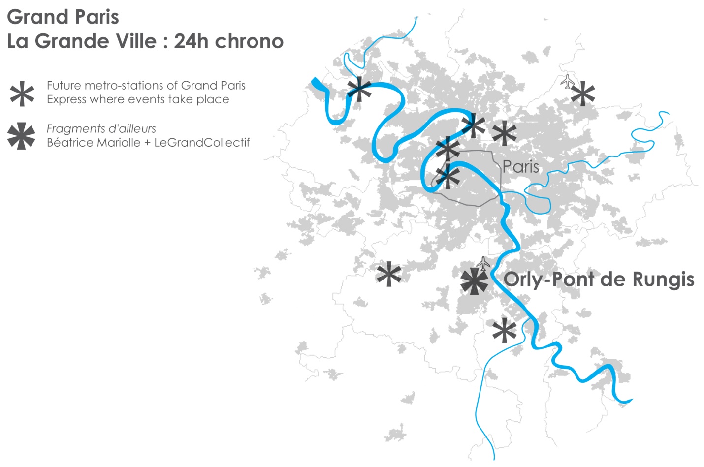
Figure 01: “situation Railway station”(Le Grand Collectif, 2012.)
This map shows the metropolitan context of the action-research, situating the 9 railway stations involved in the event of the Île de France area.
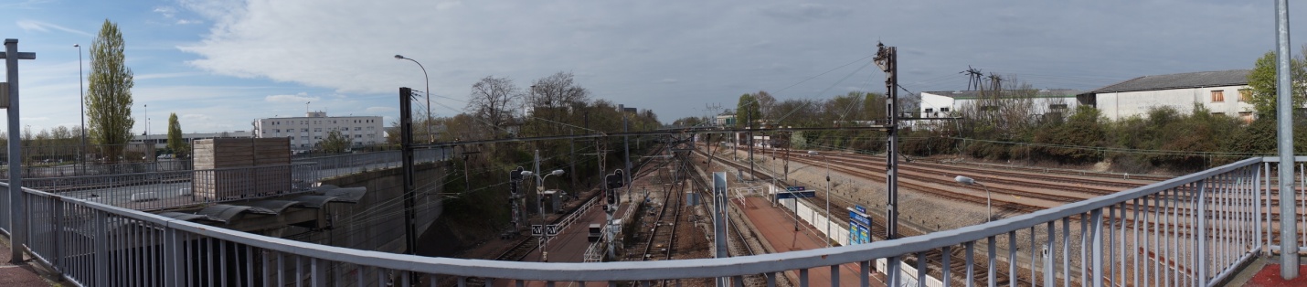
Figure 02: “Panorama Railway station 1”(Le Grand Collectif, 2012.)
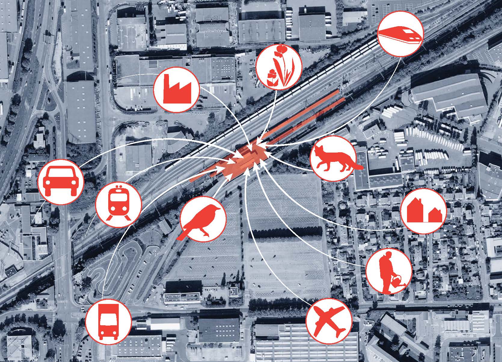
Figure 03: “place-unit” (Le Grand Collectif, 2012.)
Place unit: linking territory components to a single place: the railway station platform.
COLLECTIF READYMAKE
Factory of urban and architectural intentions
Camille Bianchi and Marie-Ange Jambu, architects
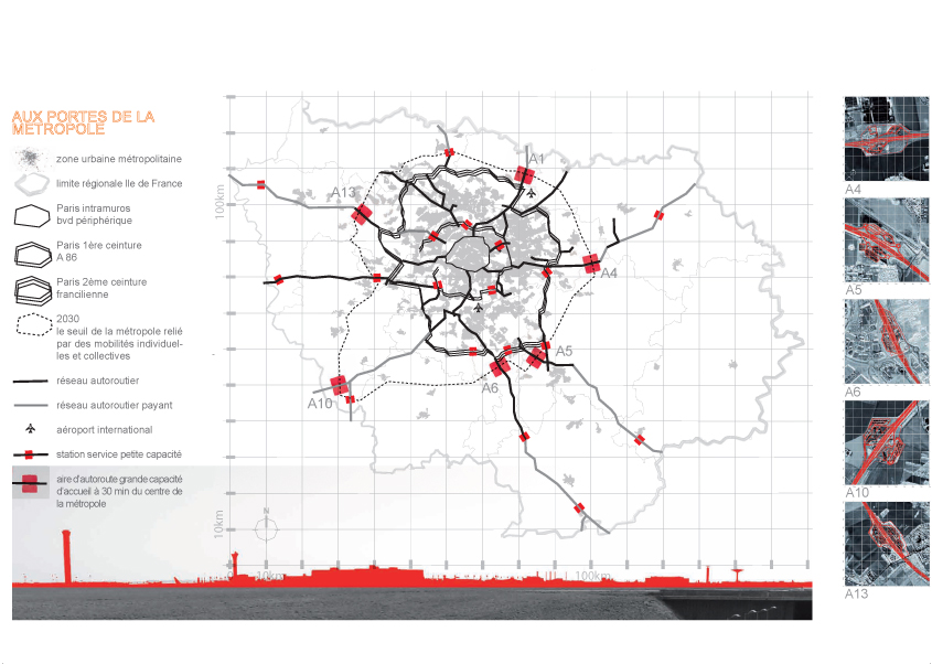
Figure 04: “At the metropolis gates” (Source: Readymake, 2012.)
When toll plazas on highways, currently barren and mono-functional areas, are involved in the issue of urban development and wary of the notion of limits on a
regional scale: gateways become the support for multiple exchanges and activities, depending on their strategic positioning.
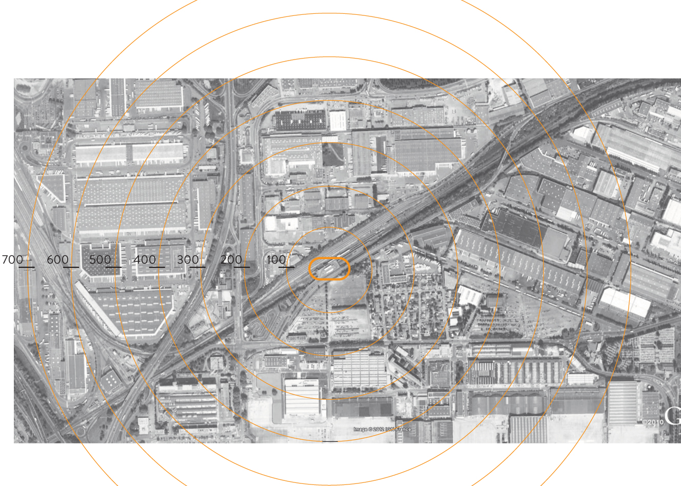
Figure 05: “The local scale: radar scale of immediate vicinity of Pont de Rungis railway station, outskirts of Paris”. (Source: Readymake, 2012.)
This map shows the immediate vicinity of Pont de Rungis railway station and establishes a radio-concentric scale centered at the platform.
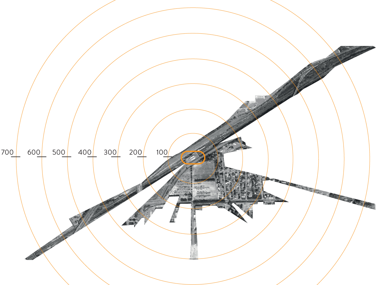
Figure 06: “Radar map” (Source: Readymake, 2012.)
The radar map is based on a re-transcription of visual emergencies, whether specific or extensive, visible from the station platform. It marks the signs visually
perceived at the pedestrian level.
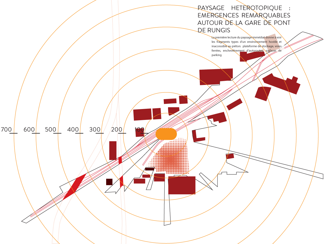
Figure 07: “Map of heterotrophies” (Source: Readymake, 2012.)
This map of heterotrophies highlights the nature of the buildings near the railway station and shows the dimension alien to human scale of storage platforms,
industrial centers, and major infrastructure. It provides information about the boundaries generated by this landscape and, in negative, the interstices through which
exploration has become possible.
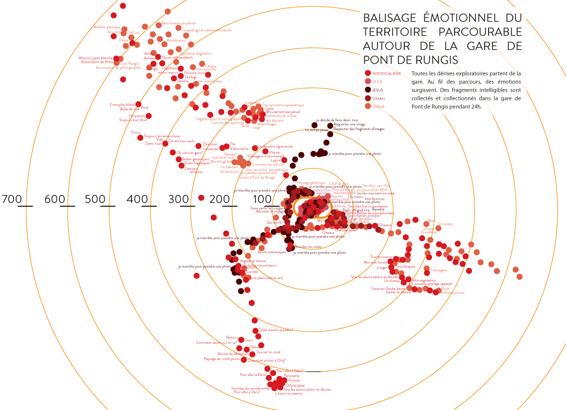
Figure 08: “Emotional map” (Source: Readymake, 2012.)
The emotional map relates to the representation of the pathways taken by different surveyors, team members, and their emotional manifestations, expressed over
territory exploration. The representation questions the sensitive dimension that emerges during practice in this territory, providing routes with emotional markers.
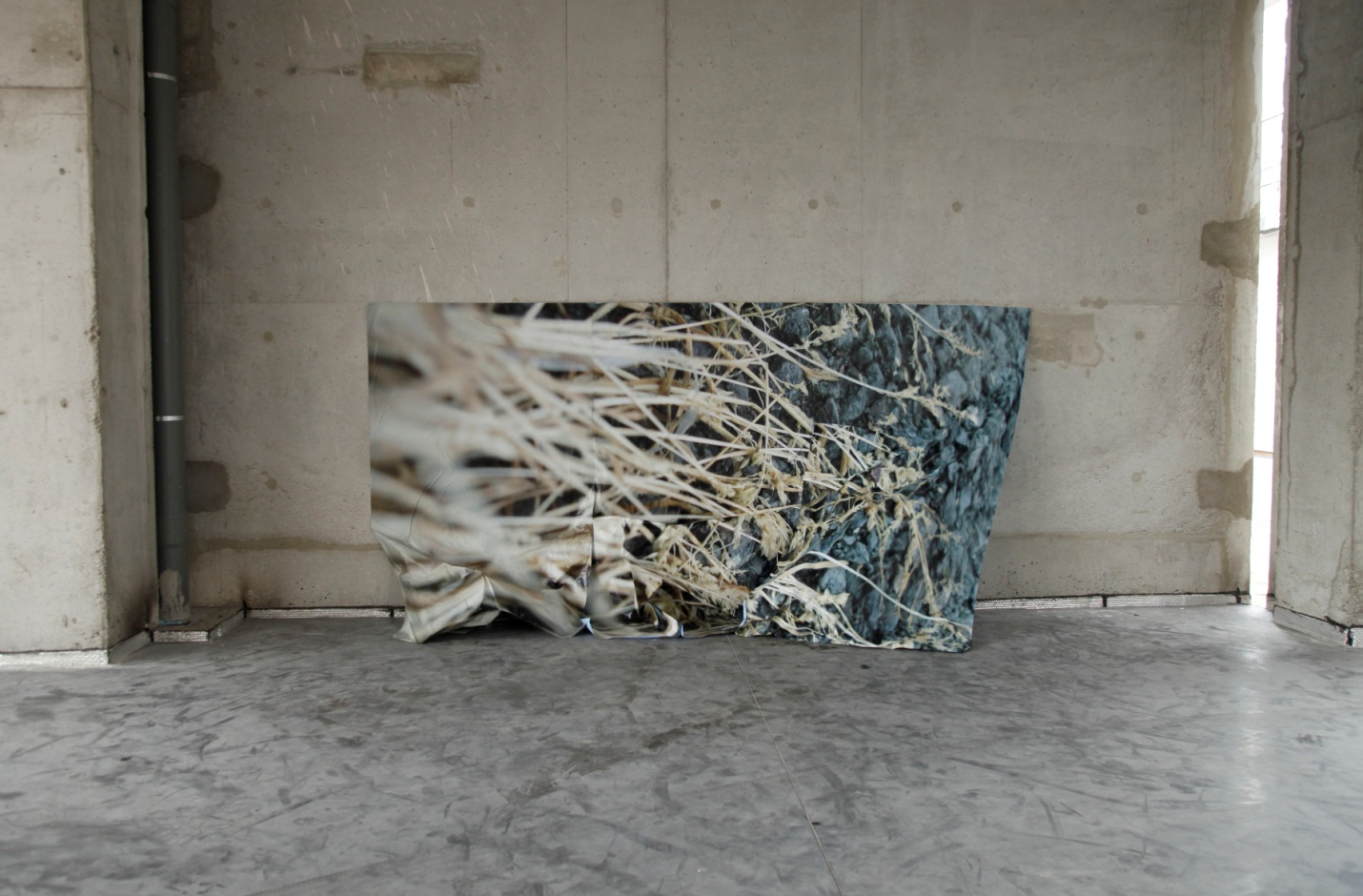
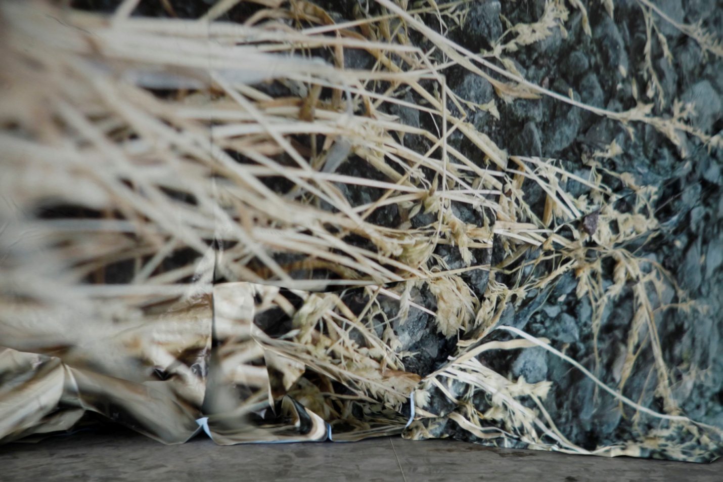
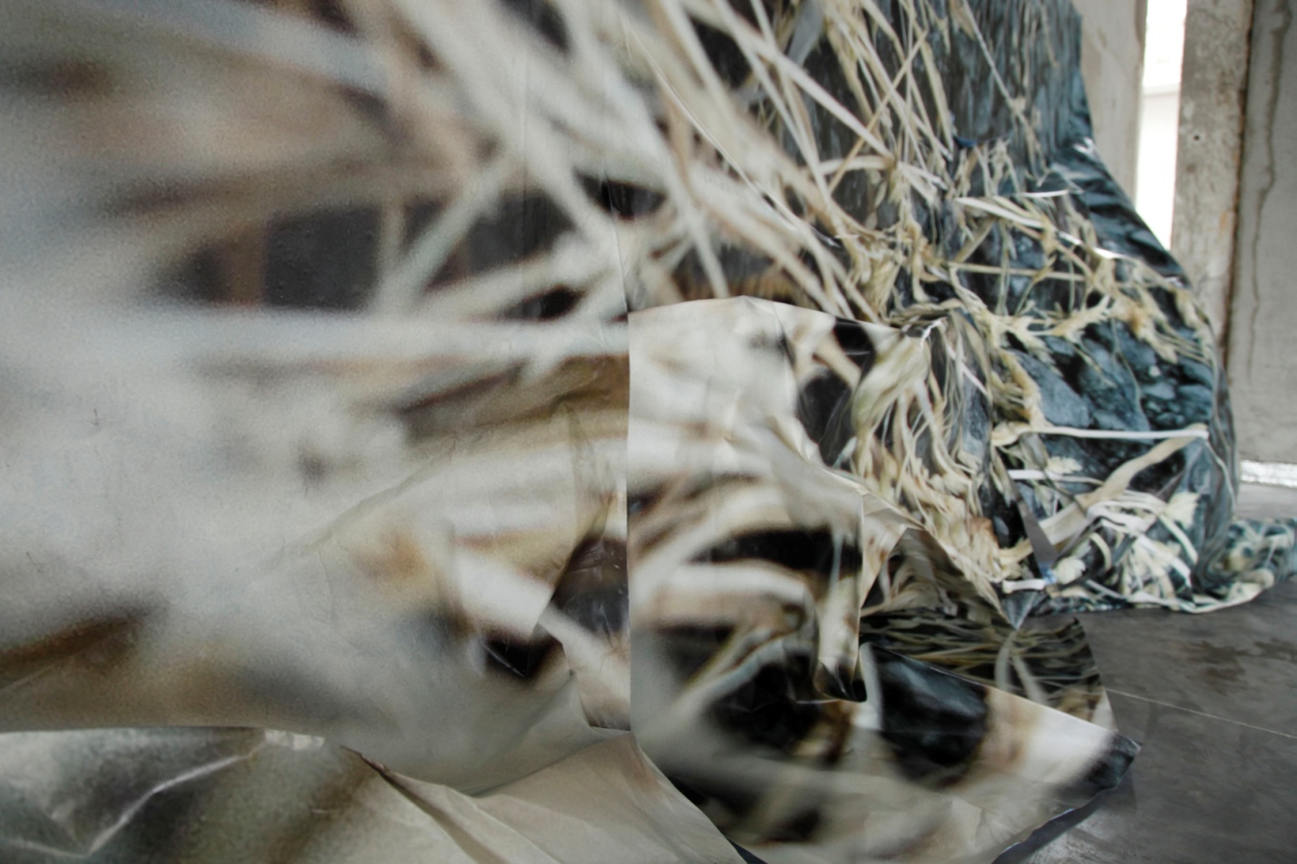
LEILA ROSE WILLIS
The artist Leila Rose Willis produced a stop-motion video from visual takes of an installation composed of photo-poster folds. The photo was taken of the installation
at Pont de Rungis railway station.
The work of Leila Rose Willis relies heavily on paper and in its folds. Here she intends to take possession of part of the volume of the railway station (platform),
pasting photographic impressions on 4mx3m paper, inspired by the shape of subway posters.
The theme she wants to develop is geared toward natural surrounding interstices, based on the play of scales that mark the railway station space with giant macros of
the Subagglo vegetal environment. The folds, or origami, make it possible to break through the simple context of the poster, which in this case goes beyond its framing
and expands onto surrounding walls and ground.
COLLECTIF INTERSCALAIRE
Elsa Brés-Mariolle, Victor Maréchal, architects-video producers
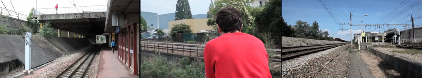
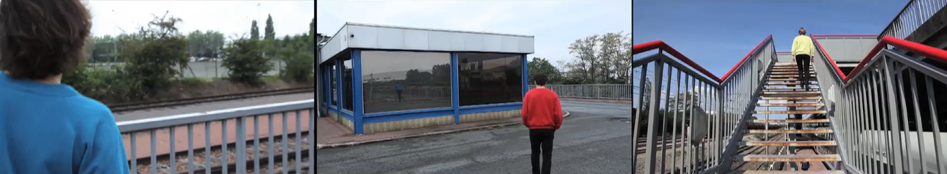
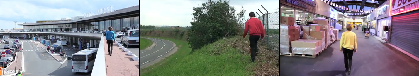
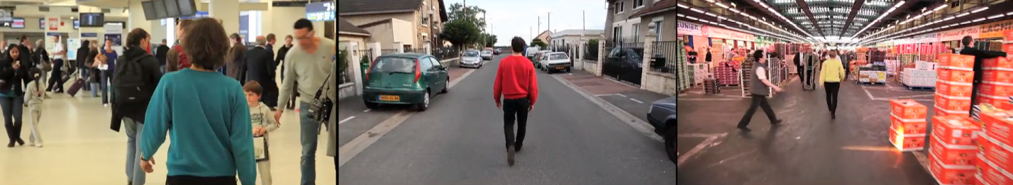
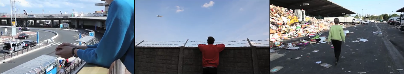
The work of the collective Interscalaire rests on three video sequences simultaneously projected in the form of a triptych of which five screenshots are shown
here.
Interscalaire Collective bases its research on accessibility at the pedestrian level of the territory surrounding the train station, by placing itself before the
large industrial and infrastructural extensions, visible on the map of heterotrophies (re. Readymake cartography).
Three surveyors crisscross the Grand Paysage and conquer industrial obstacles interfering with margins, roads, railways, and airport and logistics platforms.
Following the inframince flora continuum, revealed here by video sequences that accompany the surveyors’ progress, there emerge pathways that establish a new slow
mobility network, where at first glance it appears to be wholly void.