editorial
editorial
entrevista
interview
artigos submetidos
submitted papers
tapete
carpet
artigo nomads
nomads paper
projetos
projects
expediente
credits
próxima v!rus
next v!rus
issn 2175-974x | ano 2018 year
semestre 01 semester

Mídias móveis como interfaces urbanas: espaço, tempo e memória
Juliana Rocha Franco é Doutora em Comunicação e Semiótica e professora da Escola de Design da Universidade Estadual de Minas Gerais. É pesquisadora nas áreas de Comunicação, Semiótica e Design sobre processos de percepção e produção de sentido na contemporaneidade.
Como citar esse texto: FRANCO, J. R. Do fim das geografias às mídias móveis como interfaces urbanas: espaço, tempo e memória. V!RUS, São Carlos, n. 16, 2018. [online] Disponível em: <http://www.nomads.usp.br/virus/virus16/?sec=4&item=2&lang=pt>. Acesso em: 14 Jul. 2025.
Resumo
A partir da crítica a ideia do “fim das geografias”, busca-se compreender as relações entre espaço urbano, mídias móveis e a memória. Pautando-se no estudo de obras e projetos realizados com o uso de tecnologias móveis, discutiremos o entrelaçamento dos fluxos de informação e os espaços da cidade. Por fim, abordar-se a relação entre a interconexão de layers informacionais à construção da memória coletiva e narrativas não-lineares, que se dão por meio do trinômio entre espaço, tempo e memória.
Palavras-chave: Mídias móveis, Espaço urbano, Memória
1 Introdução
Atualmente, vários teóricos (HARVEY, 2001; SANTAELLA, 2007; LEMOS, 2010) têm apresentado reflexões sobre as conexões entre as tecnologias e importantes transformações sociais. Um aspecto importante de tais transformações pode ser notado no modo como as tecnologias da informação tem modificando nossas noções de espaço, bem como a forma como experimentamos e representamos esse espaço. As tecnologias móveis ligadas aos dispositivos de localização têm exercido um grande impacto em nossa cultura (SANTAELLA, 2008; LEMOS, 2010). “Mídias móveis” tem sido a expressão por excelência para se referir aos atuais dispositivos portáteis de computação pervasiva e novas redes móveis de telecomunicações.
A conectividade onipresente, possibilitada pelos telefones mídias móveis, tem desencadeado novas práticas sócio espaciais e padrões de interação em ambientes urbanos que apontam para a superação da dicotomia real/virtual. Estas não se opõem, mas, cada vez mais, se complementam e se atualizam no espaço tangível. Vivenciamos uma era da conexão que articula espaço virtual, espaço urbano e mobilidade.
A despeito de leituras que preconizaram a “desmaterialização”, a “diluição do real pelo virtual” (MEYROWITZ, 1985; BAUDRILLARD, 1994), a Internet tem ultrapassado as suas fronteiras virtuais, e “pingado” no mundo tangível (RUSSELL, 1999, p. 1). Uma camada de elementos digitais tem coberto o nosso ambiente e possibilita formas de interação entre espaços virtuais, telemáticos e o mundo tangível. A capacidade simultânea para interagir, tanto com um contexto local, quanto com uma localização física separada, tem alterado nossa percepção do espaço.
No presente texto buscaremos compreender como essas mudanças podem ser apreendidas nas formas de representação desse espaço, no caso, a partir de projetos que se utilizam de mídias móveis e suas relações com o tempo e a memória. Um aspecto fundamental das mídias móveis que buscaremos ressaltar é a possibilidade da (re) construção de narrativas e estruturas não-lineares localizadas sobre a cidade, possibilitando um rearranjo dos processos de construção da memória social, na direção de formas colaborativas de construção da memória coletiva a partir de novas percepções do espaço urbano.
Dirigiremos nosso olhar para trabalhos promovidos por artistas, ativistas, pesquisadores que desenvolvem propostas que relacionam mídias móveis e o espaço. Interessam-nos especialmente aqueles que conectam arte, geografias informais e mapas à experiência do espaço urbano.
Processos de criação que se utilizam de tecnologias móveis, associadas a dispositivos de localização e, de alguma forma, promovem mapeamentos e cartografias, não apenas para registrar as diferentes formas pelas quais a cidade está materialmente presente, mas também como uma intervenção criativa no espaço urbano, como um processo de criação do espaço, acentuando não somente a cidade tangível, física, mas também a cidade vivida e experimentada.
2 A multiplicidade em camadas
A emergência da internet e o aumento dos espaços virtuais e interações online em fins do século XX, levou vários estudiosos a declararem o fim o eminente fim dos lugares físicos. Uma configuração social na qual, segundo Graham (1998, p. 167):
As tecnologias de mídia, computação e telecomunicações convergem e integram, os custos de equipamentos e transmissão despencam tornando a distância virtualmente independente; as redes integradas de banda larga começam a mediar todas as formas de entretenimento, interação social. A vida humana se tornaria liberada das restrições de espaço e dos efeitos de atritos da distância.
Outros autores diante desse contexto, também proclamaram o "fim da geografia" (O'BRIEN, 1992), "morte da distância" (CAIRNCROSS, 1997), dentre outras perspectivas na qual o espaço físico seria substituído por interações virtuais. Tal perspectiva se baseia, segundo Graham (1998, p. 167):
[...] na perspectiva de substituição e transcendência, ou seja, na ideia de que a territorialidade humana e as dinâmicas espaciais da vida humana, de alguma forma podem ser substituídas usando novas tecnologias.
Em uma direção semelhante, Nicolas Negroponte, um dos fundadores e professor do Media Lab, do MIT, afirmou que a vida digital criaria cada vez menos dependência de se estar em um lugar específico em um momento específico (NEGROPONTE, 1995, p. 165).
Engel (2012, p. 6) no seu relato do desenvolvimento da palavra "cidade", mostra que, historicamente, o termo foi posicionado contra algum outro espaço ou prática: por exemplo, urbano/rural ou centro/periferia, na qual a definição de cidade estava condicionada ao seu oposto binário e não a suas possibilidades e mulplicidades. Segundo o autor, até há relativamente pouco tempo (final do século XX), estas distinções binárias em grande parte persistiam não apenas na cultura popular, mas também no meio acadêmico e profissional.
Especialmente importante para o presente trabalho é separação conceitual da cidade de "bits” e da cidade de “átomos" (GRAHAM, 2004, p. 5). Para Engel (2012, p. 6) “a construção opositiva é decorrente da percepção da cidade como um container. Posição que inicialmente foi apresentada por Mumford (1961)”.
Para Mumford (1961 apud WILSON, 1995, p. 147), a cidade era um container, ou seja:
[...] ela era e tinha que ser um espaço finito. Ele acreditava que o “gigantismo disperso” da cidade do século XX a conduzia inexoravelmente à megalópole e daí para a necrópole, a morte da cidade. A divisão nítida entre o campo e a cidade não existe mais, escreveu ele. O container original desapareceu inteiramente.
Na verdade, a ideia da cidade como container possibilitou pensar que, com a emergência de novas formas de comunicação possibilitadas pela informática, o espaço das cidades se tornaria obsoleto, uma vez que o container, onde se desenrolariam as relações sociais, seria deslocado para o que Castells chama espaço dos fluxos: “O espaço dos fluxos refere-se à possibilidade tecnológica e organizacional, sem contiguidade geográfica (CASTELLS, 2000, p. 14)”.
O problema de tal leitura da cidade informacional encontra-se na sua abordagem como uma cidade dupla, fragmentada e polarizada. Entretanto, apesar das leituras que preconizam a desmaterialização do espaço físico em detrimento do espaço virtual, os espaços físicos e lugares urbanos persistem e proliferaram. Com a ascensão da economia da informação, as tecnologias tornaram-se cada vez mais entrelaçadas à vida da/na cidade.
As mídias móveis tornam a tela de computador obsoleta: o referente é o espaço físico. Essas tecnologias possibilitam a vinculação de informações ao espaço tangível e reposicionam o espaço de dados, digital, como algo que não é mais separado do espaço tangível. Para tal fenômeno alguns autores utilizam os termos embodied virtualization (WEISER, 1991, p. 98) ou embodied interaction (DOURISH, 1999, p. 1). Tal forma de pensar desafiaria a própria definição do que a cidade é. Para Tuters (2004, p. 2) estamos testemunhando uma transformação da noção histórica da "cidade".
Dentro desse contexto no qual a cidade tornou-se um amálgama de espaço físico e digital, o espaço urbano não deveria ser considerado como uma construção puramente física em oposição a uma instância desmaterializada virtual. Aliás, conforme afirma Beiguelman (2013, p. 147), a oposição real/virtual é um mero anacronismo do século XX. Santaella (2009, p. 205) explica o porquê: “ uma vez que a percepção se dá́ em um continuum sensório, não há́ por que postular uma separação drástica entre pretensos espaços virtuais”.
Nesse sentido, o projeto Can You See Me Now? Realizado em parceria entre o grupo Blast Theory1 e Mixed Reality Lab2 é emblemático de como tais espaços se entrelaçam em uma multiplicidade em camadas. O trabalho é uma espécie de “performance jogo”. A interface permite que os jogadores online interajam com os jogadores de rua, representados como pontos em movimento no mapa. O objetivo dos jogadores online é fugir dos jogadores de rua. Se um corredor se aproxima pelo menos cinco metros de um jogador online, este é “capturado” e forçado a deixar o jogo (Vídeo 1).
Vídeo 1. Can you see me now? Tokyo. Fonte: Vimeo. Disponível em: https://vimeo.com/5489402. Acesso em 01 dez. 2017.
Can You See Me Now? cria um mundo coerente e rico para o jogador. Ambos os tipos de jogadores ocupam espaços físicos e online, habitando um layer espacial que entrelaça diferentes dimensões da cidade. Jogos, que operam na confluência dos espaços, são chamados por Silva (2009, p. 404 - 424) de hybrid reality games. Os "espaços" neste projeto são todos sobrepostos, misturados e turvos. O Mapa é uma rede de complexa-camadas de redes de interação.
Para Bambozzi (2011, p. 104):
O “entranhamento” dos fluxos de informação nas formas físicas do mundo vem permitindo imaginar geografias possíveis, em processos experimentais e subjetivos – em cartografias que se potencializam a partir de novos procedimentos de medição, localização e posicionamento.
Dessa forma o que vimos sugerindo ao longo do presente trabalho, para além das oposições, é uma justaposição dos espaços, que poderiam ser lidos em camadas como existindo em várias esferas simultaneamente. Nosso argumento a seguir, é que tal configuração poderia funcionar como uma interface para a construção da memória coletiva.
3 A cidade como interface para a construção da memória
Ao longo da última década, a computação ubíqua, redes sociais e tecnologias móveis tornaram-se parte integrante de nossas vidas sociais e práticas de trabalho, bem como moldar a nossa forma de dar sentido às nossas culturas e participar como cidadãos. É possível afirmar que tal processo permitiu enfatizar caráter das cidades como um lugar de encontro social nos quais coexistem múltiplas experiências de tempo e espaço, resultante de suas teias relacionais sobreposição de diferentes ritmos de tempo e alcance geográfico.
Dentro desse contexto, é importante ressaltar que ao mesmo tempo em que “moldamos” nossas cidades, somos moldados por ela. A maneira como nos movemos e memorizamos nossa experiência espacial promove modificações na maneira como nosso cérebro é configurado. Pesquisas têm mostrado (MAGUIRE et al., 2000) que pessoas que lidam com grande volume de informação espacial em processos navegacionais (como taxistas, por exemplo) registram um aumento do volume do hipocampo posterior, que armazena uma representação espacial do ambiente e pode se expandir regionalmente para acomodar elaboração desta representação em pessoas com uma elevada necessidade de habilidades de navegação.
Assim, se conforme afirmamos acima, a maneira como experimentamos o espaço modifica nossa estrutura cerebral, a cidade, na medida em que media nossa relação com o mundo e nos oferece acesso a informações, pode ser compreendida como uma interface que “conecta uma realidade objetiva e um sistema cognitivo, também real, mas que, para permanecer, teve que codificar esta realidade” (VIEIRA, 2007, p. 101).
O que estamos denominando interface é, segundo Drucker (2011, p. 8):
[…] uma entidade, uma estrutura fixa ou determinada que suporta certas atividades, ela tende a reificar da mesma forma que um livro faz com a descrição tradicional. Mas nós sabemos que um códex não é uma coisa, mas um conjunto estruturado de códigos que suportam ou provocam uma interpretação que é por si só performativa.
Tal processo ocorre em uma rede de mediações, que também funcionam como interfaces: acessamos a cidade através de outras interfaces, num contínuo “jogos de espelhos”. Dentro desse contexto, emerge a questão da importância que o espaço e especificamente o espaço urbano e sua experiência desempenha na formação e preservação de memórias coletivas. Rossi (1982) apresenta a cidade como o lugar da memória coletiva.
Concordando com Rossi, pode-se dizer que a própria cidade é a memória coletiva de seu povo, e, como a memória, está associada a objetos e lugares. Ao tratar da memória coletiva, é importante fazer algumas considerações sobre o trabalho de Halbwachs sobre os quadros sociais da memória e a presença de lugares físicos e espaciais da memória coletiva. Segundo Santos (1998, p. 154), a afirmação central de Halbwachs sobre a memória é a de que, quaisquer que sejam as lembranças do passado que possamos ter, por mais que pareçam resultado de sentimentos, pensamentos e experiências exclusivamente pessoais, elas só podem existir a partir dos quadros sociais da memória. Halbwachs (apud SANTOS, 1998, p. 155), ao considerar os quadros sociais da memória, está levantando a questão da presença do “outro genérico” em nossa percepção da realidade, e mostra a importância da informação como mediadora de construção de identidades.
Ao ressaltar o caráter social da memória e explicar que nem mesmo as memórias mais íntimas podem ser pensadas em termos exclusivamente individuais, Halbwachs enfatiza tanto o caráter social quanto interativo da memória. A lembrança é resultado do convívio do indivíduo com outros indivíduos (SANTOS, 1998, p. 155). Esta rede de relações e interações está presente na memória que cada um guarda como “exclusivamente“ íntima e pessoal. A memória é adquirida à medida que o indivíduo toma como sua as lembranças do grupo com o qual se relaciona: há um processo de apropriação de representações coletivas por parte do indivíduo em interação com outros indivíduos em um processo indissociável da linguagem. As reivindicações que são feitas e as histórias que são contadas em nome da memória podem alterar a compreensão do mundo das pessoas e, é claro, alterar as formas em que eles atuam na ou sobre aquele mundo.
Uma série de projetos possibilita destacar a importância da memória coletiva, a fim de apreender e compreender o espaço urbano da cidade, bem como a importância do espaço urbano na criação e transmissão de tais memórias.
Um bom exemplo é projeto Urban Tapestries (2002, p. 4)3 concebido pelo grupo Proboscis4. O projeto se configurou como uma plataforma digital que permitia as pessoas anexarem suas próprias anotações virtuais da cidade (Vídeo 2). Possibilitando que os cidadãos comuns incorporassem o conhecimento vivido à paisagem informacional da cidade. Assim, criava-se uma memória coletiva materializada em um "mapa coletivo mnemônico".
Entretanto, é preciso ressaltar que a tecnologia por si só não possibilita tal processo. Dessa forma, uma crítica possível a tais processos seria a possibilidade de eles ficarem presos a seu caráter indicial e terminando por funcionar apenas como banco de dados de fotos, filmes e sons geolocalizados, como podemos observar em determinadas aplicações comerciais.
Conforme afirma Silveira (1991, p. 43):
A simples acumulação de fatos passados, todos eles necessariamente particulares, seria incapaz de produzir ideias genuinamente gerais sobre os fenômenos e dar garantias reais de que a conduta futura alcançará - mesmos nos limites da probabilidade - os fins procurados.
Vídeo 2. Urban Tapestries Contexts. Fonte: Vimeo. Disponível em: https://vimeo.com/1065977. Acesso em 01 dez. 2017.
Dessa forma, conforme Maia, (2000, p. 55) “apropriar-se produtivamente de um material mediático pressupõe uma atitude reflexiva”, sua capacidade de acionar experiências, histórias de vida, elementos presentes na memória coletiva, nos rituais ou nas narrativas disponíveis de uma dada comunidade para produzir novos sentidos e orientações simbólicas, que os próprios atores sejam capazes de reconhecer.
Na mitologia Grega, quando Ariadne, enamorada por Teseu, condenado a morrer no labirinto, morada do temível minotauro, pediu a Dédalo, construtor do labirinto, por ajuda, ele não lhe deu um mapa comum, desenhado em papel, com a saída assinalada. Ele lhe deu um novelo de linha. A linha materializaria o rastro do herói em sua jornada através do labirinto funcionando como um método para anotar o espaço e permitiu a Teseu retraçar seus movimentos através do espaço e encontrar seu caminho através do labirinto5.
O rastro, não só no caso de Teseu, mas também no caso das mídias móveis pode ser compreendido como uma interface para acessar o espaço e o tempo, como podemos observar no projeto Amsterdam Real Time (2002)6. Em outubro e novembro de 2002, a artista Esther Polak, em colaboração com Jeroen Kee e Waag Society7 realizou o projeto Amsterdam Realtime (Fig. 1), no contexto de uma exposição cartográfica no Amsterdam Municipal Archive na qual uma seleção de mapas da cidade seria apresentada8.
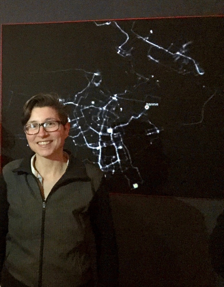
Fig. 1: . Amsterdam Real Time. Fonte: Wikimedia. Disponível em: https://commons.wikimedia.org/wiki/File:Esther_Polak_RealTime_Amsterdam_Museum_04.jpg. Acesso em 01 dez. 2017.
O projeto consistiu em uma instalação e mapeamentos da cidade de Amsterdam, feitos por participantes, convidados através de flyers e website, que, durante dois meses, em 2002, utilizaram um equipamento portátil com GPS integrado, com o objetivo de traçar suas rotinas diárias pelas ruas de Amsterdam.
O formulário de inscrição para o projeto solicitou uma quantidade considerável de informações biográficas (e geográficas). Presumivelmente, a intenção era garantir um leque de participantes com diferentes padrões de movimento na cidade. O dispositivo portátil foi desenvolvido pela Waag Society9.
Segundo Polak (2011, s.p.), cada habitante de Amsterdam tem um mapa da cidade em sua cabeça. A forma como eles se movem sobre a cidade e as escolhas efetuadas neste processo são determinadas por este mapa mental10 (FRANCO, 2012). Sob essa perspectiva, o projeto Amsterdam Realtime, inspirado nessa ideia dos mapas mentais, buscou apreender a visualizar o mapeamento da trajetória dos habitantes da cidade.
Gordon e Silva (2011, p. 45) afirmam que os mapas nestas peças não antecederam à obra. Em vez disso, eles foram construídos através de contribuições dos participantes e de suas experiências do espaço físico. Como resultado, eles poderiam ser transformadores das experiências do usuário do espaço urbano. Ao eliminar a malha viária urbana ou mapa base, Amsterdam Realtime mostra os percursos (anteriores e em tempo real) sugerindo um sistema orgânico para representar os padrões de utilização que se altera em tempo real. Ao visualizar esses dados contra um fundo preto pontos, traços, linhas, aparecem. A partir dessas linhas, um mapa de Amsterdam se constrói.
As rotinas diárias desses cidadãos revelaram um novo mapa. Todas as participações individuais, quando colocados juntas, deram um mapa extremamente realista da mobilidade dentro de Amsterdam. Em torno da noção de navegação concentra-se o processo de caminhar uma rota, enfatizando a memória e experiência. Cada participante construía, com seu próprio traço, uma versão pessoal da cidade: como presente de aniversário, uma mãe escreveu o nome do filho em letras gigantes nas ruas da cidade em torno de lugares que foram significativas para ele. Alguém usou o padrão das ruas de Amsterdam para desenhar a pé, de bicicleta e de barco, um pombo (HOPMAN, 2005, p. 54).
Amsterdam real time (realizado em 2002) antecipou uma característica, hoje comum para os usuários, das mídias móveis: A convergência de tempo e espaço. As tecnologias de mapeamento location aware permitem visualizar a posição do usuário sobre a superfície do mapa, geralmente na forma de um ponto colorido. À medida que o usuário se movimenta, a marcação se move com ele. Este momento aparentemente banal traz algo de extraordinário: até onde pesquisamos, é a primeira vez que a representação do espaço se dá “ao mesmo tempo” que a do tempo.
4 Conclusões
As práticas de mapeamento em mídias móveis possibilitam mapear entidades, coletivos, locais e tornam visíveis relações e expõem a logística e as relações até então escondidos ou ignorados. Tuters (2012, p. 11) propõe repensar as mídias locativas menos como tecnologia e mais como uma metáfora na qual a localidade é articulada a objetos, entidades e atores em rede. Dessa forma, sugerimos que as mídias móveis oferecem uma estrutura conceitual pela qual examinam-se certas montagens tecnológicas e seus potenciais impactos sociais.
As mídias móveis permitem criar pontes que entrelaçam materialidade e imaterialidade, sendo, simultaneamente, experiências do ciberespaço e do mundo tangível operando em nossa construção da realidade. Dessa forma, as espacialidades contemporâneas possibilitam a construção da memória coletiva a partir da noção de sistema de relações, processos, conexões e multiplicidades em um processo que se dá na confluência de fluxos em um processo de interação e conectividade entre espaços virtuais, telemáticos e o mundo tangível da cidade.
Os mapas navegacionais se configuram como um traçado das relações e configurações que, neste caso, não são um contexto, a priori, mas um efeito de performatividade. Esses mapas não funcionam somente como uma ferramenta de orientação, mas também como um mapa habitado que é composto pelas inter-relações entre actantes, associações, objetos, pessoas. Mapas em movimento no tempo.
Referencias
BAMBOZZI, L. et al. Mediações, tecnologia, espaço público: panorama crítico da arte em mídias móveis. São Paulo: Conrad, 2010.
BAUDRILLARD, J.Simulacra and simulation. Ann Arbor: University of Michigan Press, 1994.
BEIGUELMAN, G. Arte pós-virtual: Criação e agenciamento na era da internet das Coisas e da próxima natureza. In: PESSOA, F. (Ed.). Cyber-Arte-Cultura Vitória/Rio de Janeiro: Museu Vale ES/ Suzy Muniz Produções, v.8, p.146 -175, 2013.
CAIRNCROSS, F. The Death of distance: how the communications revolution will change our lives. Boston: Harvard Business School Press, 1997.
DOURISH, P. Embodied interaction: Exploring the foundations of a new approach to HCI. 1999. Disponível em: http://www.dourish.com/embodied/embodied99.pdf. Acesso em: 01 fev. 2017.
CASTELLS, M. A sociedade em rede. São Paulo: Paz e Terra, 1999.
DRUCKER, J. Humanities approaches to interface theory. Culture Machine, v. 12, n. 0, 2011. Disponível em: ttp://www.culturemachine.net/index.php/cm/article/viewArticle/434. Acesso em: 01 fev. 2017.
ENGEL, A. Flickering cities multimedia city fabrics and the changing nature of citizenship. 2012. Disponível em: http://digitalcommons.wayne.edu/cgi/viewcontent.cgi?article=1537&context=oa_dissertations. Acesso em: 01 dez. 2017.
FRANCO, J. R. Cartografías subversivas e geopoéticas. Geografares, n. 12, p. 114 - 137, 2012.
FRANCO, J. R. A “virada espacial” e a semiótica: uma proposta alternativa ao pensamento binário. LÍBERO. n. 36, p. 65 - 76, 2016.
GARCIA, E. D. El Mito de Teseo en la literatura. Archivum Ovetensis, XXXIII. Revista de la Facultad de Filología de la Universidad de Oviedo; 1983. Disponível em: http://dialnet.unirioja.es/servlet/fichero_articulo?codigo=144016. Acesso em: 01 abr. 2018.
GORDON, E.; SILVA, A. S. Net Locality: why location matters in a networked world. malden: Wiley-Blackwell, 2011.
GRAHAM, S.The end of geography or the explosion of place? conceptualizing space, place and information technology. Progress in Human Geography, v. 22, n. 2, p. 165-185, 1998.
HARVEY, D. Condição pós-moderna. São Paulo: Edições Loyola, 2001.
HOPMAN, A. Amsterdam Real Time. In: BROUWER, J.; MULDER, A., et al (Ed.). Art & D: Research and development in art. Rotterdam: V2_Publishing/NAI Publishers, 2005. p. 48 - 58.
LEMOS, A. Post—mass media functions, locative media, and informational territories: New ways of thinking about territory, place, and mobility in contemporary society. Space and Culture, v. 13, n. 4, p. 403 - 420, 2010.
MAIA, R. Identidades coletivas: negociando novos sentidos, politizando as diferenças”. In: Contracampo: revista do Mestrado em Comunicação, Imagem e Informação. Niterói: Instituto de Arte e Comunicação Social, 2000.
MEYROWITZ, J. No sense of place: The impact of electronic media on social behavior. New York: Oxford University Press New York, 1985.
MUMFORD, L. The City in History. Its Origins, Its Transformations, and Its Prospects, New York, Harcourt, Brace & World, 1961.
NEGROPONTE, N. Being digital. New York: Knopf, 1995.
O'BRIEN, R. Global financial integration: the end of geography. New York: Council on Foreign Relations Press, 1992.
POLAK, E. Reflexões sobre o processo criativo de Amsterdam realtime. Correspondência via e-mail Amsterdam, 12 de novembro de 2002. Disponível em: http://www.beelddiktee.nl/tekst/. Acesso em 01 dez. 2017.
ROSSI, A. The architecture of the city. Cambridge: MIT Press, 1982.
RUSSELL, B. Headmap manifesto. 1999.
SANTAELLA, L. Linguagens líquidas na era da modernidade. São Paulo: Paulus, 2007.
______. A Estética política das mídias locativas. Nómadas, v. 28, p. 128-137, 2008.
SANTOS, M. S. Sobre a autonomia das novas identidades coletivas: Alguns problemas teóricos. Revista Brasileira de Ciências Sociais, v. 13, n. 38, 1998. Disponível em: http://dx.doi.org/10.1590/S0102-69091998000300010. Acesso em: 01 mar. 2015.
SILVEIRA, L. F. B. Na origem está o signo. Trans/Form/Ação, v. 14, p. 45 - 52, 1991.
SILVA, A. S. Hybrid reality and location-based gaming: redefining mobility and game spaces in urban environments. Simulation & Gaming, v. 40, n. 3, p. 404 - 424, 2009.
TUTERS, M. The locative commons: situating location-based media in urban public space. Electronic Proceedings of the 2004 Futuresonic Conference, 2004. Disponível em: http://www.itu.dk/people/amie/Digital %E6stetik/Befri_kunsten/Litteratur/The locative commons.pdf. Acesso em: 01 fev. 2017.
______. From Control Society to Parliament of Things: designing Object Relations with an Internet of Things, 2009. Disponível em: http://escholarship.org/uc/item/3zj2t89z. Acesso em: 01 fev. 2017.
VIEIRA, J. Semiosfera e o conceito de Umwelt. In MACHADO, I. (Ed.). Semiótica da cultura e semiosfera. São Paulo: Annablume/Fapesp, 2007. p. 99 -112.
WILSON, S. Information arts: intersections of art, science, and technology. Cambridge: MIT Press, 2002.
WEISER, M. The computer for the 21st century. Scientific american, v. 265, n. 3, p. 94 - 104, 1991.
1 Disponível em: http://www.blasttheory.co.uk/projects/can-you-see-me-now/. Acesso em 01 dez. 2017.
2 O Mixed Reality Lab (MRL), é um grupo interdisciplinar de pesquisadores University of Nottingham, UK Reino Unido, chefiada pelo Professor Steve Benford. O MRL compreende cientistas da computação, programadores, designers de interface, etnógrafos e sociólogos em pesquisas que buscam explorar os limites entre o espaço real e virtual.
3 Disponivel em: http://research.urbantapestries.net. Acesso em 01 dez. 2017.
4 Em parceria com as instituições London School of Economics, Birkbeck College, Orange, HP Research labs, France Telecom R&D UK, Ordnance Survey.
5 Para mais informações sobre o mito do Minotauro ver: GARCIA, E. Domingo.El Mito de Teseo en la Literatura.Archivum Ovetensis, XXXIII. Revista de la Facultad de Filología de la Universidad de Oviedo; 1983.
6 Ver em: http://realtime.waag.org. Acesso em 01 dez. 2017.
7 A Waag Society é um laboratório de mídia cultura e tecnologia. Vários membros da Waag Society, em particular Marleen Stikker, Tom Demeyer e Aske Hopman, estiveram envolvidos no desenvolvimento do projeto. Suas origens e experiência combinados são ilustrativos de orientação geral do laboratório, que abrange sociologia, ciência política, teatro e informática e tecnologia audiovisual e multimídia.
8 Exposição Maps of Amsterdam 1866 - 2000, Amsterdam City Archives, 03 Outubro a 01 de dezembro de 2002.
9 Para mais detalhes técnicos, ver Hopman (2005, p. 54).
10 As reflexões de Polak sobre o processo criativo de Amsterdam RealTime foram registrados em um e-mail enviado aos amigos por Polak no início de 2002. Uma tradução em Inglês do texto deste e-mail está disponível em:
Mobile media as urban interfaces: space, time and memory
Juliana Rocha Franco is a Doctor in Communication and Semiotics and teaches at the Design School of the State University of Minas Gerais. She is a researcher in the areas of Communication, Semiotics and Design on processes of perception and production of meaning in the contemporary times.
How to quote this text: Franco, J. R. From the end of geographies to mobile media as urban interfaces: space, time and memory. V! RUS, São Carlos, n. 16, 2018. [e-journal] [online] [online] Available at: <http://www.nomads.usp.br/virus/virus16/?sec=4&item=2&lang=en>. [Accessed: 14 July 2025].
Abstract
The critique of the "end of geographies idea," seeks to understand the relations between urban space, mobile media, and memory. Drawing on the study of works and projects carried out with the use of mobile technologies, we will discuss the relationship between information flows and the spaces of the city. Finally, the relationship between the interconnection of informational layers with the construction of collective memory and non-linear narratives, which occur through the triad between space, time and memory, is addressed.
Keywords: Mobile media, Urban space, Memory
1 Introduction
Currently, several scholars (Harvey, 2001; Santaella, 2007; Lemos, 2010) have presented reflections on connections between technologies and social transformations. An aspect of such alterations is how information technology has modified our notions of space, as well as how we experience and represent that space. Mobile technologies linked to localization devices have had a significant impact on our culture (Santaella, 2008; Lemos, 2010). "Mobile media" has been the quintessential expression to refer to current portable devices of pervasive computing and new mobile telecommunications networks.
The ubiquitous connectivity, enabled by mobile media phones, has triggered new socio-spatial practices and patterns of interaction in urban environments that point to overcoming the real/virtual dichotomy, that have no opposition, but, increasingly, complement each other and update themselves in the actual space. We live in an era of connection that articulates virtual space, urban space, and mobility.
In spite of readings that advocated "dematerialization," the "dilution of the real by the virtual" (Meyrowitz, 1985; Baudrillard, 1994), the Internet has surpassed its virtual boundaries. A layer of digital elements has been covering our environment and enables forms of interaction between virtual spaces, telematics and the tangible world. The simultaneous ability to interact, both with a local context and with a separate physical location, has altered our perception of space.
In this text, we will seek to understand how these changes may be seized in the forms of representation of that space, in this case, from projects that use mobile media and its relationship with time and memory. A fundamental aspect of mobile is the possibility of (re) construction of narrative and non-linear structures and located on the city, allowing a rearrangement of the processes of social memory construction towards collaborative forms of collective memory construction from new perceptions of urban space.
We will direct our attention to works by artists, activists, researchers who develop proposals that relate mobile media and space. We are especially interested in those who connect art, radical geography and maps to the experience of urban space.
Creation processes that, using mobile technologies and localization devices to mapping, not only as a record of ways in which the city is materially present, but also as a creative intervention in urban space as a process of creation of space, emphasizing not only the tangible, physical city but also the city lived and experienced.
2 The multiplicity in layers
The emergence of the internet and the rise of virtual spaces and online interactions in the late 20th century, led several scholars to declare the end of physical places. A social setting in which, according to Graham (1998, p. 167, our translation):
Media technologies, computing, and telecommunications would converge and integrate, making the distance virtually independent; integrated broadband networks began to mediate forms of entertainment, social interaction. In this context, to some scholars, human life would become free from the constraints of space and the effects of friction of distance.
Other authors also proclaimed the "end of geography" (O'Brien, 1992), "death of distance" (Cairncross, 1997), among other perspectives in which virtual interactions would replace physical space. Such a view is based, according to Graham (1998, p. 167, our translation):
[...] on the perspective of substitution and transcendence, that is, on the idea that human territoriality and the spatial dynamics of human life can somehow be replaced using new technologies.
In a similar direction, Nicolas Negroponte, a founder and professor at the Media Lab of MIT, said that the digital life would create less dependence of being in a specific place at a specific time (Negroponte, 1995, p. 165).
Concerning the development of the word "City," Engel (2012, p. 6) shows that, historically, the term appears positioned against some binary oppositions of some space or practice. For example, urban/rural or center/periphery, in which the definition of the city was subject to their opposite and not by their possibilities and multiplicities. According to the author, until relatively recently (late 20th century), these binary distinctions mainly persisted not only in popular culture but also in the academic and professional sectors.
Especially relevant for the present work is the conceptual separation of the city from "bits" and the city of "atoms" (Graham, 2004, p. 5). For Engel (2012, p. 6, our translation) the oppositional construction is due to the perception of the city as a container. A position that was initially presented by Mumford (1961).
For Mumford (1961 apud Wilson, 1995, p. 147, our translation) the city was a container:
[...] that is to say it was and had to be a finite space. He believed that the ‘sprawling giantism’ of the twentieth-century city was leading inexorably to megalopolis and thence to necropolis, the death of the city.
In fact, the idea of the city as a container made it possible to think that city space would become obsolete. Especially after the emergence of new forms of communication enabled by information technology. Since the container, where social relations would unfold, would be shifted to which Castells called the space of flows: "the space of flows refers to the technological and organizational possibility of organizing the simultaneity of social practices without geographic contiguity" (Castells, 2000, p. 14, our translation).
The problem of such a reading of the informational city lies in its approach as a "double city" fragmented and polarized. However, despite the readings that advocate the dematerialization of physical space to the detriment of virtual space, physical spaces and urban places persist and proliferate. With the rise of the information economy, technologies have become increasingly intertwined with the life of the city
Mobile media makes the computer desktop screen obsolete: the referent is the physical space. These technologies enable the binding of information to the physical space and reposition the digital data space as something that is no longer separate from the physical space. For this phenomenon, some authors use the terms embodied virtualization (Weiser, 1991, p. 98) or embodied interaction (Dourish, 1999, p. 1). Such a way of thinking would defy the very definition of what the city is. For Tuters (2004, p. 2) we are witnessing a transformation of the historical notion of the "city."
Within this context in which the city became an amalgam of physical and digital space, urban space should not be considered as a purely physical construction as opposed to a virtual dematerialized instance. In fact, as Beiguelman (2013, p. 147) states, the real/virtual opposition is a mere anachronism of the twentieth century. Santaella (2009, p. 205, our translation) explains why: once perception occurs on a sensorial continuum, there is no reason to postulate a separation between so-called virtual spaces.
In this sense, the project "Can You See Me Now?" held in partnership between the group Blast Theory and Mixed Reality Lab is emblematic of how such spaces intertwine in a multiplicity of layers. The work is a kind of "performance game". The interface allows them to interact with the street players, represented as moving points on the map. Runners can see the relative position (on the map) of online players represented as white dots on a map of the same area on their mobile device screens. The goal of online players is to get away from the street players. If a runner approaches at least five meters from an online player, he is "caught" and forced to leave the game (Video1).
Video 1. Can you see me now? Tokyo. Source: Vimeo. Available in https://vimeo.com/5489402. [Accessed in 01 Dez. 2017].
"Can You See Me Now?" creates a coherent and rich world for the player. Both types of players occupy physical and online spaces, inhabiting a space layer that interweaves different dimensions of the city. Games, operating at the confluence of spaces, are called by Silva (2009, p. 404 - 424) of hybrid reality games. The "spaces" in this project are all superimposed, mixed and cloudy. The Map is a network of complex-layers of interaction networks.
For Bambozzi (2011, p. 104, our translation):
The "entrenchment" of information flows in the physical forms of the world has allowed us to imagine possible geographies, in experimental and subjective processes - in cartographies that are enhanced by new measurement, localization, and positioning.
In this way, what we have been suggesting throughout the present work, apart from oppositions, is a juxtaposition of spaces, in layers as existing in several spheres simultaneously. Our next argument is that such a configuration could function as an interface for the construction of collective memory.
3 The city as an interface for the construction of memory
Over the last decade, ubiquitous computing, social networks, and mobile technologies have become an integral part of our social lives and work practices, as well as shaping our way of making sense of our cultures and participating as citizens. It is possible to affirm that this process allowed emphasizing the character of cities as a place of social encounter in which multiple experiences of time and space coexist, resulting from their relational webs overlapping of different rhythms of time and geographic reach.
Within this context, it is important to emphasize that while we "shape" our cities, we are shaped by it. The way we move and memorize our spatial experience promotes modifications in the way our brains configuration. For example, Maguire et al. (2000) show that people dealing with large amounts of spatial information in navigational processes ( taxi drivers, for example), can record a volume increase in the posterior hippocampus. That stores a spatial representation of the environment and can expand regionally to accommodate elaboration of this representation in people with a high need for navigation skills.
Thus, if according to what we cited above, the way we experience space modifies our brain structure, the city, insofar as it mediates our relation to the world and gives us access to information, can be understood as an interface that "connects an objective reality and a cognitive system, also real, but which, in order to remain, had to encode this reality "(Vieira, 2007, p. 101). What we are calling the interface is, according to Drucker (2011, p. 8, our translation):
[…] interface as a thing, an entity, a fixed or determined structure that supports certain activities, it tends to reify in the same way a book does in traditional description. But we know that a codex book is not a thing but a structured set of codes that support or provoke an interpretation that is itself performative.
This process occurs in a network of mediations, which also function as interfaces: we access the city through other interfaces, in a continuous "sets of mirrors." Within this context emerges the question of the importance that space and specifically the urban space and its experience plays in the formation and preservation of collective memories. Rossi (1982) presents the city as the place of collective memory.
In accordance to Rossi, one can say the city itself is the collective memory of its people, and like memory, associated with objects and places. Regarding collective memory, it is essential to make some considerations about Halbwachs' work on the social frameworks of memory and the presence of physical and spatial places of collective memory. According to Santos (1998, p. 154), Halbwachs' central claim to memory is that whatever memories of the past we may have, however much they seem to be the result of exclusively personal feelings, thoughts, and experiences, it came from the social frameworks of memory. Halbwachs (apud Santos, 1998, p. 155), considering the social frameworks of memory, is raising the question of the presence of the "other generic" in our perception of reality and shows the importance of information as a mediator of identity construction.
By emphasizing the social character of memory and explaining that not even the most intimate memories can be thought in exclusively individual terms, Halbwachs emphasizes both the social and interactive nature of memory that is the result of the individual living with other individuals (Santos, 1998, p. 155). This network of relationships and interactions is present in the memory that each one keeps as "exclusively" intimate and personal. Memory is acquired as the individual takes as his or her the memories of the group with which it relates: there is a process of appropriation of collective representations by the individual in interaction with other individuals in an integrated process of language. The claims and the stories about memory can change people's understanding of the world and, of course, change how they act in or on that world.
A series of projects makes it possible to highlight the importance of collective memory to seize and understand the urban space of the city, as well as the importance of urban space in the creation and transmission of such memories.
A good example is Urban Tapestries project (2002, p. 4) 1 conceived by Proboscis group 2. The project was set up as a digital platform that allowed people to attach their virtual city notes (Video 2) and Enabled ordinary citizens to incorporate lived knowledge into the city's informational landscape. Thus, a collective memory was created materialized in a "collective mnemonic map".
However, technology alone does not enable such a process. In this way, a possible criticism of such procedures would be the possibility of them being stuck to their indicial character and ending up working only as a database of geolocated photos, movies, and sounds, as we can observe in certain commercial applications.
According to Silveira (1991, p. 43, our translation):
The mere accumulation of past events, all of which are necessarily particular, would be incapable of generating genuinely general ideas about phenomena, and give real guarantees that future conduct will reach, even within the limits of probability, the purposes sought.
Video 2. Urban Tapestries Contexts. Source: Vimeo. Available at: https://vimeo.com/1065977. [Accessed 01 Dez. 2017].
Thus, according to Maia, (2000, p. 55, our translation) "appropriating oneself productively from a mediatic material presupposes a reflexive attitude,", an ability to trigger experiences, life stories, elements present in the collective memory, rituals or available narratives of a given community to produce new meanings and symbolic orientations, that the actors themselves can recognize.
In Greek mythology, when Ariadne, enamored of Theseus, condemned to die in the labyrinth, home of the fearsome minotaur, asked Daedalus, builder of the labyrinth, for help, he did not give him a common map drawn on paper with the indicated exit. He gave him a ball of thread. The line would materialize the hero's trail on his journey through the labyrinth running as a method to note space and allowed Theseus to retrace his movements through space and find his way through the labyrinth.
The trail, not only in the case of Theseus but also in the case of mobile media can be understood as an interface to access space and time, as we can observe in the project Amsterdam Real Time (2002)3. In October and November 2002, the artist Esther Polak, in collaboration with Jeroen Kee and Waag Society4 , carried out the Amsterdam RealTime project (Fig. 1) in the context of a cartographic exhibition in the Amsterdam Municipal Archive in which a presentation of a selection of Amsterdam’s city maps5.
Fig. 1: . Amsterdam Real Time. Source: Wikimedia. Available at: https://commons.wikimedia.org/wiki/File:Esther_Polak_RealTime_Amsterdam_Museum_04.jpg. [Accessed in 01 Dez. 2017].
The project consisted of installation and mapping of the city of Amsterdam made by the participants who were invited through flyers and website, for two months (in 2002) to carry equipment portable with GPS, and tracing their daily routines through the streets of Amsterdam.
The application form for the project requested a considerable amount of biographical (and geographical) information. Presumably, the intention was to ensure a range of participants with different patterns of movement in the city. The portable device was developed by the Waag Society6.
According to Polak (2011, s.p. our translation), every inhabitant of Amsterdam has a map of the city in his head. This mental map7 (Franco, 2012). determines the way each one moves around the city and the choices made in this process. Through this premise, Amsterdam Realtime sought to visualize these mental maps by mapping the trajectory of the inhabitants of the city.
Gordon and Silva (2011, p. 45) argue that the maps in these pieces did not precede the work. Instead, they were built through input from participants and their experiences of physical space. As a result, they could be transformers of user experiences of urban space. By eliminating the urban road network or base map, Amsterdam Realtime shows the routes (previous and in real time) suggesting an organic system to represent the patterns of use that change in real time. When viewing this data against a black background, dots, dashes, and lines appear. From these lines, a map of Amsterdam emerges.
The daily routines of these citizens revealed a new map. All of the individual entries, when put together, gave a realistic map of mobility within Amsterdam. Around the notion of navigation is concentrated the process of walking a route, emphasizing memory and experience. Each participant constructed a personal version of the city with his trait: as a birthday present, a mother wrote her son's name in giant letters on the streets of the city around places that were significant to him. Someone used the pattern of the streets of Amsterdam to draw on foot, bicycle and boat, a pigeon (Hopman, 2005, p. 54).
Amsterdam RealTime (conducted in 2002) anticipated a characteristic, now familiar to users, of mobile media: the convergence of time and space. Location-aware mapping technologies allow you to view the user's position on the map surface (usually in the form of a colored dot). As the user moves, the marking runs with it. This seemingly trivial moment brings something extraordinary: as far as we look, it is the first time that the representation of space occurs "at the same time" as that of time.
4 Final Considerations
The practices of mapping in mobile media allow mapping entities, collectives, places and make visible relationships and expose the logistics and relations hitherto hidden or ignored. Tuters (2012, p. 11) proposes to rethink the locative media less like technology and more like a metaphor in which the locality couple with objects, entities, and actors network. Thus, we suggest that mobile media offers a conceptual framework by which technological assemblages and their potential social impacts can be examined.
Mobile media allow us to create bridges that interweave materiality and immateriality, simultaneously being experiences of the cyberspace and the tangible world operating in our construction of reality. In this way, contemporary spatialities allow the creation of collective memory from the notion of a system of relations, processes, connections, and multiplicities in a process that occurs at the confluence of flows in the process of interaction and connectivity between virtual spaces, telematic spaces and the tangible world of the city.
Navigational maps as a mapping of relations and configurations which, in this case, are not a priori context, but a performativity effect. These maps do not function only as an orientation tool, but also as an inhabited map that is composed of the interrelationships between actants, associations, objects, people. Maps of moving in time.
References
Bambozzi, L. et al. Mediações, tecnologia, espaço público: panorama crítico da arte em mídias móveis. São Paulo: Conrad, 2010.
Baudrillard, J.Simulacra and simulation. Ann Arbor: University of Michigan Press, 1994.
Beiguelman, G. Arte pós-virtual: Criação e agenciamento na era da internet das Coisas e da próxima natureza. In: PESSOA, F. (Ed.). Cyber-Arte-Cultura. Vitória/Rio de Janeiro: Museu Vale ES/ Suzy Muniz Produções, v.8, p.146 -175, 2013.
Cairncross, F. The Death of distance: how the communications revolution will change our lives. Boston: Harvard Business School Press, 1997.
Dourish, P. Embodied interaction: Exploring the foundations of a new approach to HCI. 1999. Available at: http://www.dourish.com/embodied/embodied99.pdf. [Accessed: 01 fev. 2017].
Castells, M. A sociedade em rede. São Paulo: Paz e Terra, 1999.
Drucker, J. Humanities approaches to interface theory. Culture Machine, v. 12, n. 0, 2011. Available at: http://www.culturemachine.net/index.php/cm/article/viewArticle/434. [Accessed: 01 fev. 2017].
Engel, A. Flickering cities multimedia city fabrics and the changing nature of citizenship. 2012. Available at: http://digitalcommons.wayne.edu/cgi/viewcontent.cgi?article=1537&context=oa_dissertations. [Accessed: 01 dez. 2017].
Franco, J. R. Cartografías subversivas e geopoéticas. Geografares, n. 12, p. 114 - 137, 2012.
Franco, J. R. A “virada espacial” e a semiótica: uma proposta alternativa ao pensamento binário. LÍBERO. n. 36, p. 65 - 76, 2016.
Garcia, E. D. El Mito de Teseo en la literatura. Archivum Ovetensis, XXXIII. Revista de la Facultad de Filología de la Universidad de Oviedo; 1983. Available at: http://dialnet.unirioja.es/servlet/fichero_articulo?codigo=144016. [Accessed: 01 abr. 2018].
Gordon, E.; Silva, A. S. Net Locality: why location matters in a networked world. malden: Wiley-Blackwell, 2011.
Graham, S. The end of geography or the explosion of place? conceptualizing space, place and information technology. Progress in Human Geography, v. 22, n. 2, p. 165-185, 1998.
Harvey, D. Condição pós-moderna. São Paulo: Edições Loyola, 2001.
Hopman, A. Amsterdam Real Time. In: Brouwer, J.; Mulder, A., et al (Ed.). Art & D: Research and development in art. Rotterdam: V2_Publishing/NAI Publishers, 2005. p. 48 - 58.
Lemos, A. Post—mass media functions, locative media, and informational territories: New ways of thinking about territory, place, and mobility in contemporary society. Space and Culture, v. 13, n. 4, p. 403 - 420, 2010.
Maia, R. Identidades coletivas: negociando novos sentidos, politizando as diferenças”. In: Contracampo: revista do Mestrado em Comunicação, Imagem e Informação. Niterói: Instituto de Arte e Comunicação Social, 2000.
Meyrowitz, J. No sense of place: The impact of electronic media on social behavior. New York: Oxford University Press New York, 1985.
Mumford, L. The City in History. Its Origins, Its Transformations, and Its Prospects, New York, Harcourt, Brace & World, 1961.
Negropont, N. Being digital. New York: Knopf, 1995.
O'Brien, R. Global financial integration: the end of geography. New York: Council on Foreign Relations Press, 1992.
Polak, E. Reflexões sobre o processo criativo de Amsterdam realtime. Correspondência via e-mail Amsterdam, 12 de novembro de 2002. Available at: http://www.beelddiktee.nl/tekst/. [Accessed: 01 dez. 2017].
Rossi, A. The architecture of the city. Cambridge: MIT Press, 1982.
Russell, B. Headmap manifesto. 1999.
Santaella, L. Linguagens líquidas na era da modernidade. São Paulo: Paulus, 2007.
______. A Estética política das mídias locativas. Nómadas, v. 28, p. 128-137, 2008.
Santos, M. S. Sobre a autonomia das novas identidades coletivas: Alguns problemas teóricos. Revista Brasileira de Ciências Sociais, v. 13, n. 38, 1998. Available at: http://dx.doi.org/10.1590/S0102-69091998000300010. [Accessed: 01 mar. 2015].
Silveira, L. F. B. Na origem está o signo. Trans/Form/Ação, v. 14, p. 45 - 52, 1991.
Silva, A. S. Hybrid reality and location-based gaming: redefining mobility and game spaces in urban environments. Simulation & Gaming, v. 40, n. 3, p. 404 - 424, 2009.
Tuters, M. The locative commons: situating location-based media in urban public space. Electronic Proceedings of the 2004 Futuresonic Conference, 2004. Available at: http://www.itu.dk/people/amie/Digital %E6stetik/Befri_kunsten/Litteratur/The locative commons.pdf. [Accessed: 01 fev. 2017].
______. From Control Society to Parliament of Things: designing Object Relations with an Internet of Things, 2009. Available at: http://escholarship.org/uc/item/3zj2t89z. [Accessed: 01 fev. 2017].
Vieira, J. Semiosfera e o conceito de Umwelt. In MACHADO, I. (Ed.). Semiótica da cultura e semiosfera. São Paulo: Annablume/Fapesp, 2007. p. 99 -112.
Wilson, S. Information arts: intersections of art, science, and technology. Cambridge: MIT Press, 2002.
Weiser, M. The computer for the 21st century. Scientific american, v. 265, n. 3, p. 94 - 104, 1991.
1 Available at: http://research.urbantapestries.net. [Accessed in 01 dez. 2017].
2 In partnership with the institutions London School of Economics, Birkbeck College, Orange, HP Research labs, France Telecom R & D UK, Ordnance Survey.
3 Available at: http://realtime.waag.org. [Accessed in 01 fev. 2017].
4 The Waag Society is a media culture and technology lab. Several members of the Waag Society, in particular Marleen Stikker, Tom Demeyer and Aske Hopman, were involved in the development of the project. Their combined backgrounds and experience are illustrative of the laboratory's general orientation, which covers sociology, political science, theater and computer science, and audiovisual and multimedia technology.
5 Exhibition Maps of Amsterdam 1866-2000, Amsterdam City Archives, 03 October to 01 December 2002.
6 For more technical details, see Hopman (2005, p. 54).
7 Polak's reflections on the creative process of Amsterdam Realtime were recorded in an email sent to friends by Polak in early 2002. An English translation of the text of this e-mail. Available in: Http://www.beelddiktee.nl/tekst/ [Accessed 01 dez. 2013].