editorial
editorial
entrevista
interview
ágora
agora
tapete
carpet
artigo nomads
nomads paper
projetos
projects
expediente
credits
próxima v!rus
next v!rus
issn 2175-974x | ano 2019 year
semestre 02 semester

Cidades como informação
Vinicius Netto é graduado em Arquitetura e Urbanismo, Doutor em Estudos Arquitetônicos Avançados, e Professor Associado da Universidade Federal Fluminense. Desenvolve e orienta pesquisas sobre Cidade como redes de segregação, Redes de informação e Redes de interação material. É autor dos livros The Social Fabric of Cities (Routledge, 2017) e Cidade & Sociedade (2014), e co-organizador dos livros Efeitos da Arquitetura (2017) e Urbanidades (2012).
Edgardo Brigatti possui Licenciatura e Doutorado em Física e é Professor Adjunto da Universidade Federal do Rio de Janeiro. Tem experiência na área da Física dos Sistemas Complexos, com ênfase em estudos interdisciplinares com aplicações nas ciências biológicas, sociais e econômicas
João Meirelles é graduado em Engenharia de Recursos Hídricos e do Meio e Mestre em Modelagem de Sistemas Complexos. É pesquisador na Ecole Polytechnique Fédérale de Lausanne, Suíça, onde estuda as dinâmicas do metabolismo urbano, valendo-se de análises de dados, modelagem matemática e simulações.
Fabiano Ribeiro é graduado e Doutor em Física, com Pós-doutorado em Física Estatística. É Professor Adjunto no Departamento de Física da Universidade Federal de Lavras. Tem experiência na área de física estatística, complexidade, e ciência das cidades.
Caio Cacholas é Arquiteto e Urbanista, Mestre em Arquitetura e Urbanismo e colaborador do grupo de pesquisa Cidade e Informação no Programa de Pós-Graduação em Arquitetura e Urbanismo da Universidade Federal Fluminense. Estuda os impactos da morfologia urbana na ambientação de espaços públicos, e tem experiência em desenho urbano e programação.
Como citar esse texto: NETTO, V. M.; BRIGATTI, E.; MEIRELLES, J.; RIBEIRO, F. L.; CACHOLAS, C. Cidades como informação. V!RUS, São Carlos, n. 19, 2019. [online] Disponível em: <http://www.nomads.usp.br/virus/virus19/?sec=4&item=1&lang=pt>. Acesso em: 01 Jul. 2025.
ARTIGO SUBMETIDO EM 18 DE AGOSTO DE 2019
Resumo
Da física às ciências sociais, a informação é hoje vista como um aspecto fundamental da realidade. No entanto, uma forma de informação parece ainda subestimada, talvez precisamente por ser tão presente. Não entendemos completamente como cidades materializam informação, e como nossas mentes lidam com essa informação ambiental para aprender sobre o mundo, tomar decisões e participar do complexo sistema de interações sociais. Este artigo aborda três problemas que precisam ser resolvidos se quisermos entender o papel da informação ambiental: (1) o problema físico: como podemos preservar a informação no ambiente construído? (2) o problema semântico: como a forma física pode ganhar significado? (3) o problema pragmático: como usamos a informação ambiental em nossa vida cotidiana? Buscando respostas, introduzimos um modelo de três camadas de informação nas cidades, a saber: a informação ambiental no espaço físico, a informação ambiental no espaço semântico e a informação prática trocada pelos agentes. Propomos formas de estimar informação nessas diferentes camadas e aplicamos essas medidas em cenários simulados e em cidades emblemáticas em diferentes regiões do mundo. Nossos resultados sugerem que estruturas espaciais e padrões de uso do solo codificam informação, e que aspectos da informação física e semântica afetam a coordenação em sistemas de interação.
Palavras-chave: Informação, Cidades, Interação, Informação ambiental, Entropia
1 Introdução: sistemas complexos em relação
Olhe da sua janela. Você verá diferenças nas formas e tamanhos dos edifícios, alguns talvez mais altos e mais concentrados em certas partes da cidade. Você verá que esses edifícios estão conectados a ruas e que elas provavelmente também são diferentes entre si. Mesmo se você nunca esteve nesta cidade ou área antes, pode andar por ela e encontrar alguém ou algo que precisa em uma rua movimentada. Você pode se situar e encontrar seu caminho. Você nunca pensou sobre isso, mas essa é uma condição para estar no lugar onde está neste momento. Na verdade, você vive dentro de um padrão: a interação de relações reconhecíveis e variações entre espaços, uma mistura entre hierarquia e contingência, um balanço entre ordem e surpresa. Como esses padrões envolvem espaços tangíveis, as atividades das pessoas e suas possibilidades de fazer coisas juntas, essa é uma interação ao mesmo tempo material, cognitiva e social – tudo de uma vez. Você vive a interação de mentes, cidades e sociedades. Embora cada um desses sistemas seja complexo em si, o interessante é que eles acabam se relacionando. Trabalhando juntos, mentes, cidades e sociedades de alguma forma "se fundem" em um único sistema, imensamente interativo.
Este artigo trata sobre como usamos a informação em nosso ambiente para agir coletivamente nesse sistema híbrido. Trata da ‘construção mútua da informação’, tanto no ambiente quanto em nossa percepção e na 'tecitura da vida social'. Veremos a cidade como camadas de informação ambiental essencial para a interação e cooperação humanas. Para tanto, explora diversas teorias, como de informação, cognição e sistemas sociais. Por exemplo, aprendemos com a ciência cognitiva sobre como humanos se relacionam com a informação em seu ambiente. Várias abordagens afirmam que nossas mentes não apenas decodificam informação do ambiente, mas também se estendem ao ambiente (VARELA, et al., 1991; LAKOFF; JOHNSON, 1999). Desejamos explorar possibilidades relacionadas à essa ideia: como a informação é preservada no ambiente construído e como essa informação dá suporte a nossas interações.
Isso significa explorar a transição da informação para a interação. Essa transição parece estar no centro de um grande problema: como conectamos nossas ações de modo a criar uma sociedade? Como as ações individuais podem se desenvolver em um sistema coerente de interações? Como coordenamos as decisões individuais de um número enorme de pessoas? Vamos argumentar aqui que a maneira como nos organizamos em sociedade depende crucialmente de como lidamos com a informação em nosso ambiente.
Como isso acontece? Uma coisa que mentes, cidades e sociedades têm em comum é informação. Eles dependem dela. Mentes processam informação. Sociedades trocam informação para existir. O ambiente construído tem estruturas que podem conter informação. Esses sistemas processam, compartilham e preservam informação. Seria informação a ponte entre eles?
Entender as conexões entre mentes, cidades e sociedades requer vários passos metodológicos. Primeiro, vamos introduzir um modelo conceitual da ‘cidade como informação’ em três camadas. Depois, vamos propor medidas de informação para essas camadas, e aplicá-las a casos urbanos selecionados de diferentes regiões do mundo, e a cenários simulados.
2 Da informação à interação
O livro seminal de Shannon e Weaver (1949) estimulou a maioria das discussões sobre a informação. Curiosamente, Weaver oferece um caminho para entendermos a relação entre nossas mentes, ambiente e interação ao colocar três questões: “(A) Com que precisão os símbolos da comunicação podem ser transmitidos? (o problema técnico). (B) Com que precisão símbolos transmitem o significado desejado? (o problema semântico). (C) O significado recebido afeta a conduta da maneira desejada? (o problema da eficácia)”. A relação entre cognição, ambiente e interação envolve questões análogas:
1. Como codificamos e decodificamos informação no ambiente? (o problema físico)
2. Como o espaço físico pode ganhar significado? (o problema semântico)
3. Como a informação ambiental afeta nossas ações? (o problema pragmático)
Veremos que a informação está de alguma forma embutida em espacialidades tangíveis que os humanos criam como seu ambiente. Por sua vez, a informação semântica é criada na forma de conteúdos significativos em edifícios e lugares associados a certas atividades. Parece que reconhecemos lugares como configurações relacionadas às nossas ações e a uma ideia compartilhada do que elas são. Finalmente, o problema pragmático envolve o modo como usamos informação ambiental para orientar nossas ações e criar interações. Propomos lidar com essas formas de informação em três camadas interativas e sobrepostas (Figura 1).
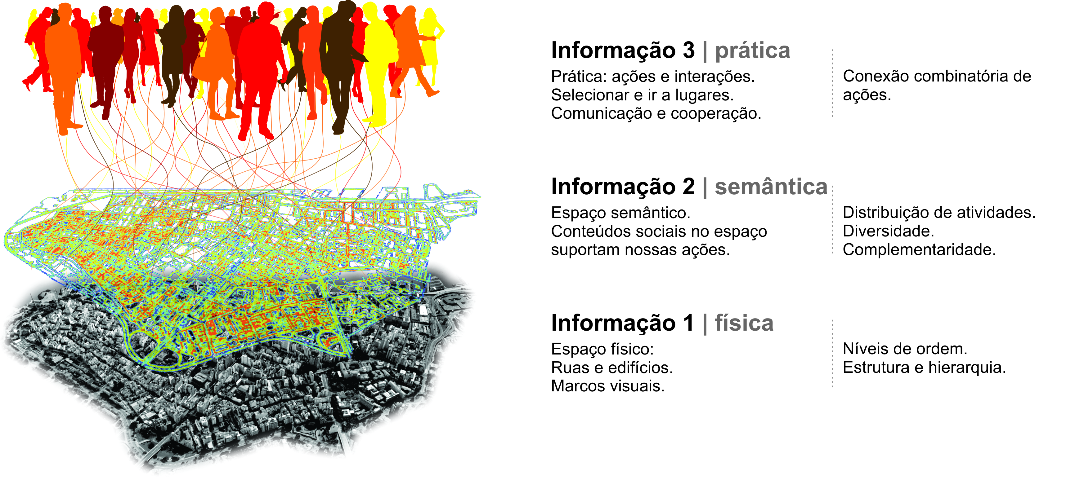
Fig. 1: Informação ambiental (1) espaço físico e (2) espaço semântico e informação encenada (3): componentes substantivos e propriedades mensuráveis. Fonte: Autores, 2019.
Teorias clássicas lidam com essas formas de informação em diferentes extensões. Por exemplo, a “imagem da cidade” de Lynch (1960) opera principalmente no nível da informação 1, uma vez que lida com caminhos e pistas físicas relacionadas à cognição e navegação. A sintaxe espacial de Hillier (1996) apreende padrões de acessibilidade em redes de ruas relacionadas à cognição, movimento e encontro. As redes de inter representação sinérgica de Haken e Portugali (2015) unem Shannon e a informação semântica como base para ações na cidade, mas sem o aspecto sistêmico da interação social.
Nosso modelo teórico coloca a camada física na base, como camada elementar e fundamental de informação relacionada à nossa cognição e navegação. A camada inclui o arranjo de elementos como edifícios e ruas, e as relações entre eles. Além disso, é uma forma de informação muito estável, que muda lentamente. Por sua vez, a camada semântica tem a ver com a forma como os edifícios e os locais suportam nossas ações. Sua estabilidade depende de quanto tempo as ações são realizadas nesses lugares e quanto tempo seus significados são retidos nas memórias das pessoas, por isso ela muda mais facilmente.
A informação ambiental 1 e 2 são inseparáveis, mas não são necessariamente intrínsecas uma à outra. Embora um edifício seja criado para suportar determinada atividade, ele pode ser usado para atividades diferentes no tempo, às vezes sem necessidade de adaptação física (por exemplo, uma casa se torna uma loja ou um escritório). Assim, a informação física tende a permanecer, enquanto a informação semântica depende das ações e memórias em curso proporcionadas pelo edifício. Finalmente, a camada de informação 3, prática, inclui os efeitos que os lugares e seus significados têm sobre os agentes, trazendo possibilidades de ação (KUPPERS, 2013). As ações incluem a fala, gestos corporais e a produção de sinais e objetos que carregam significado, e são, portanto, compreensíveis por outros agentes, desencadeando interações (HABERMAS, 1984). A informação 3 é criada na transição entre cognição, ambiente e interação. Ela envolve a informação ambiental sempre que usamos o ambiente ao nosso redor para tomar decisões individuais, atuar e nos comunicar.
Agora vejamos o que cada camada individualmente é e como elas interagem como um sistema único, unindo mentes, cidades e sociedades (Figura 2). O ambiente que nós, humanos, criamos é composto de estruturas tangíveis e não tangíveis, uma interação de espaços físicos (informação ambiental 1) e configurações de significados em espaços e lugares (informação ambiental 2). As pessoas ('agentes') codificam informação e decodificam informação do ambiente e relacionam-se a ele via percepção e cognição. Por sua vez, a cognição é situada porque se estende à ação e surge das interações entre agentes e seu ambiente. A cognição emerge das interações como processos distribuídos em operações coletivas entre agentes (HUTCHINS, 1995). Como veremos, essa extensão da cognição no ambiente e na maneira como agentes coordenam suas ações é a definição de “enação” (VARELA, et. al., 1991), ou o que chamamos de informação prática 3. A informação 3 engloba percepção, cognição e interações situadas e está profundamente relacionada a seu ambiente.
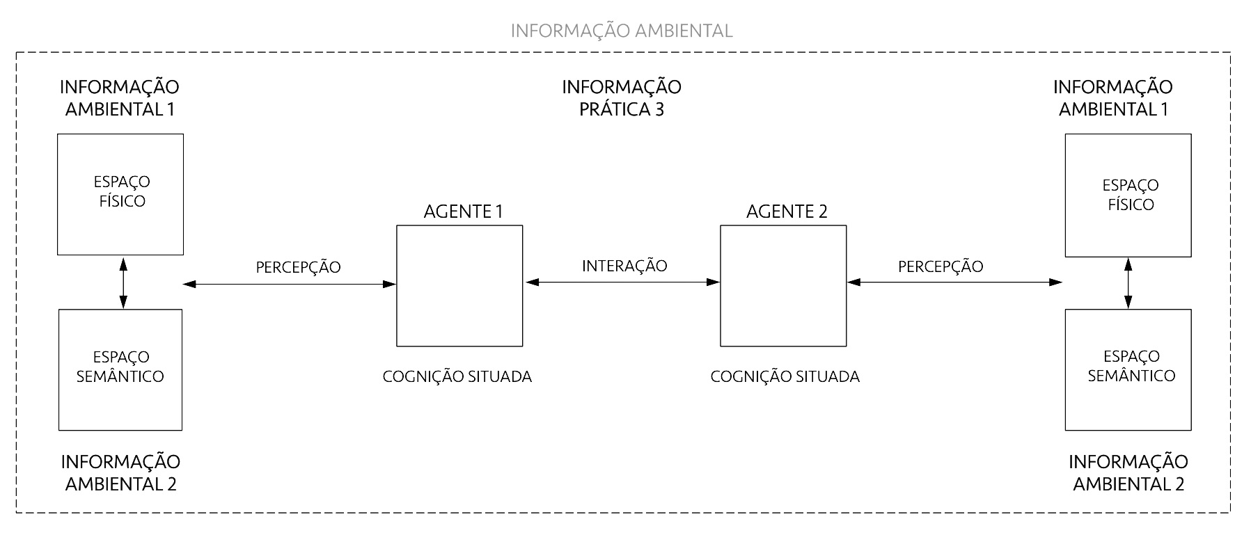
Fig. 2: Diagrama esquemático de um sistema geral de informação-interação. Fonte: Autores, 2019.
Naturalmente, todos esses itens e relacionamentos já foram muito pesquisados e precisam de definições detalhadas. Vamos abordá-los seguindo a arquitetura conceitual das três camadas.
3 Informação ambiental 1: o espaço físico
Desde o trabalho pioneiro de Shannon (1948) sobre a teoria matemática da comunicação, a noção de informação tomou outras disciplinas nos anos 1950 e 1960. Shannon chegou a uma descrição clara da informação através de uma definição probabilística de entropia, também explorada pelo físico Boltzmann (2015 [1873]) antes dele. Para ambos, a entropia é uma medida da incerteza de um sistema. Quanto maior o número de mensagens potencialmente transmitidas (SHANNON, 1948) ou o número de estados microscópicos distintos de um sistema termodinâmico (BOLTZMANN, 2015 [1873]), maior a entropia correspondente. Desde Boltzmann, a entropia está associada à desordem (PRIGOGINE; STENGERS, 1984). Arranjos físicos com maior entropia são caracterizados por níveis mais altos de aleatoriedade, imprevisibilidade ou incerteza. Por sua vez, os níveis de previsibilidade podem estar associados à ordem. As estruturas ordenadas contêm correlações como semelhanças, consistências e associações que são a “substância” da informação, como pedaços de “coerência acima e além das entidades de agrupamento e dispersão” (BATES, 2006, p. 1034).
O fato da informação poder ser codificada em estruturas físicas é interessante. A informação dura mais tempo quando preservada em entidades tangíveis (HIDALGO, 2015). Se os espaços físicos materializam informação, temos uma forma de expressar informação continuamente, enquanto essas espacialidades existirem. Podemos codificar informação no ambiente construído e decodificá-la enquanto vivermos nele. Isso abriria possibilidades cognitivas extraordinárias para guiar nossas ações.
Mas como podemos codificar informação no ambiente construído? Nesse momento, parece não haver uma resposta definitiva para essa questão. Pesquisas no campo da informação espacial parecem concentrar-se principalmente em como decodificamos informação do ambiente – por exemplo, o papel da percepção e elementos visuais na navegação e tomada de decisões espaciais (GARLANDINI;FABRIKANT, 2009). Já trabalhos empíricos em neurociência confirmam que algoritmos neurais 'integram' informação sobre lugar, distância e direção, formando mapas neurais orientados e organizados topograficamente do ambiente espacial. "Células-grade" no cérebro são ativadas sempre que nossa posição coincide com vértices de uma grade regular hexagonal abrangendo a superfície do ambiente, sendo críticas para nossos objetivos e planos de navegação (HAFTING, et al., 2005).
Uma possibilidade sob crescente atenção nesse campo é a de que níveis de regularidade e previsibilidade nos arranjos espaciais são cognitivamente úteis para ancorar nosso sistema interno de navegação (EKSTROM, et al., 2018). Podemos capturar níveis de informação física, reconhecendo a regularidade nas frequências de eventos espaciais no ambiente. Se esse for mesmo o caso, quanto maior a variação de elementos no ambiente, menores são as regularidades que permitiriam que entendamos mais rapidamente e façamos inferências sobre o espaço ao nosso redor. Mas quais arranjos espaciais contêm mais informação física?
Sugerimos que as pessoas criam informação 1 gerando níveis de ordem nos elementos mais profundos da forma construída: as agregações dos edifícios moldando o espaço urbano. Imagine a projeção de edifícios em um espaço bidimensional na forma de uma grade. Os edifícios ganham a forma de células e ocupam posições nessa grade, compondo arranjos como na Figura 3. Esses arranjos exibem diferentes níveis de ordem, aparentes na frequência das distâncias entre as células. Um caso extremo é o arranjo ortogonal (Figura 3, caso 1). Arranjos perfeitamente regulares como esse são situações raras no conjunto de arranjos possíveis – como gotas de ordem em um mar de estados desordenados. Na maioria dos estados, a distribuição de células tende a conter poucas correlações internas, como o segundo caso.
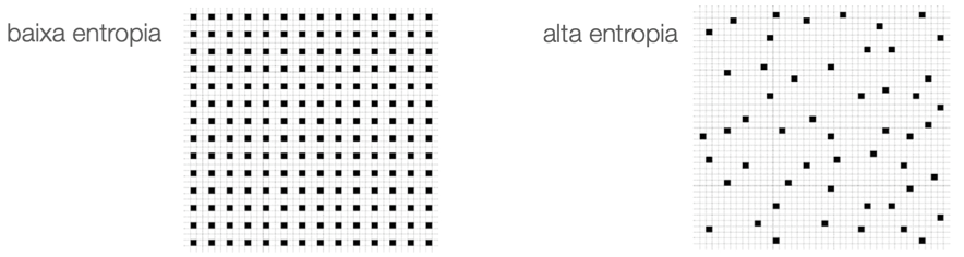
Fig. 3: Informação no espaço físico: arranjos com diferentes níveis de entropia. Fonte: Autores, 2019.
Propomos analisaros níveis de previsibilidade em arranjos físicos usando conceitos estatísticos. Uma medida da informação 1 deve ser capaz de apreender regularidades e variações nas configurações reais e diferentes situações urbanas. Para este propósito, sugerimos usar a medida de entropia de Shannon (1948). Como vimos, uma alta entropia corresponde a altos níveis de aleatoriedade ou imprevisibilidade. Em contraste, a presença de regularidades e padrões nas estruturas urbanas corresponde à menor entropia. Hipoteticamente, cidades com estruturas ordenadas ajudariam os agentes a entender seu ambiente, permitindo-lhes fazer previsões sobre áreas além de seus campos de visibilidade. As pessoas podem fazer inferências, memorizar layouts e navegar mais facilmente de um lugar para outro – digamos, apreendendo o padrão de quarteirões e interseções das ruas locais e inferindo a estrutura dos quarteirões à volta.
A medida de entropia espacial pode ser explorada para caracterizar áreas urbanas e cidades de diferentes regiões do mundo. É o que fizemos para casos empíricos emblemáticos (figura 4). Estamos cientes de que alguns casos selecionados não oferecem evidências para validar um modelo. No entanto, essas análises empíricas pretendem ilustrar o uso das medidas, mostrando sua utilidade para capturar níveis de ordem e informação em arranjos espaciais. A medida de entropia deve ser testada em relação às variações sutis em configurações urbanas reais.
Extraímos amostras de áreas geográficas de 9.000.000m2 de repositórios de mapas públicos como o Google Maps, redimensionadas em 10002 pixels em sistema monocromático e convertidas em uma matriz de valores binários para células edificadas ou livres em um espaço bidimensional. Sabemos que essa é uma redução das complexidades reais, mas a abordagem deve ser capaz de descrever mínima e suficientemente a forma urbana – daí sua redução a agregações celulares.
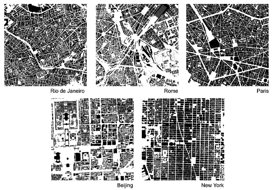
Fig. 4: Distribuições espaciais em cidades reais (9, 000, 000 m2, 1000 × 1000 células), extraídas do Google Maps. Essas seções serão usadas para calcular a entropia de Shannon e estimar o grau de desordem nos arranjos celulares. Fonte: Autores, 2019.
A análise percorre e estima as probabilidades de configurações distintas de células, e conta suas frequências nas estruturas reais (figura 5). Por exemplo, existem 512 configurações diferentes para blocos com nove células. O Rio de janeiro (figura 5, esquerda) mostra uma grande variação de configurações do tipo (a). Por sua vez, configurações do tipo (b) são muito frequentes em Manhattan (figura 5, direita). Uma alta repetição das mesmas configurações aproxima a medida de entropia de 0, ou seja, níveis altos de previsibilidade e de informação física. Já uma baixa frequência de arranjos, com grande variação e imprevisibilidade aproximam a entropia de 1.
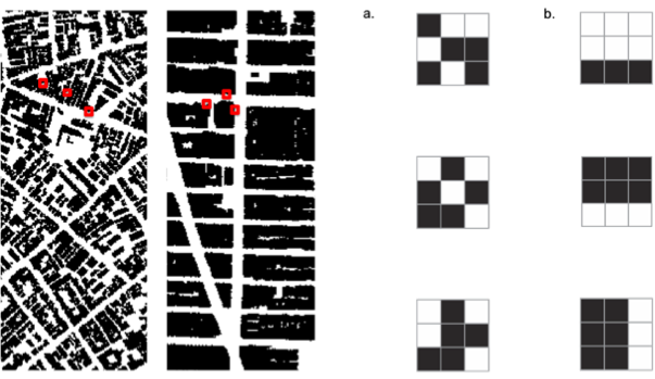
Fig. 5: Informação em arranjos celulares. Exemplos de blocos de nove células são mostrados em vermelho para áreas no Rio e Manhattan e amplificados à direita. O Rio mostra grande variação de configurações do tipo (a) indicando muitas formações irregulares, baixa previsibilidade e alta entropia. Configurações do tipo (b) são frequentes em Manhattan, contendo maior número de formações regulares, alta previsibilidade e baixa entropia. Fonte: Autores, 2019.
Os resultados para a estimativa de entropia em áreas das cinco cidades selecionadas são mostrados na Figura 6 (NETTO, et al., 2018; 2019). A área norte selecionada no Rio de Janeiro mostra o mais alto nível de desordem entre as cidades.

Fig. 6: Informação ambiental 1: valores estimados de entropia para áreas em cinco cidades selecionadas. Fonte: Autores, 2019.
É interessante notar como a informação física pode ser apreendida mesmo em pequenas escalas e que a desordem diminui à medida que o tamanho dos blocos de células analisados aumenta, e à medida que escalas maiores de ordem e correlação começam a importar. Níveis de regularidade no espaço físico parecem características informacionais úteis (HAKEN; PORTUGALI, 2015). No entanto, pode haver um limite para a natureza da informação que o espaço físico pode codificar. Que outros aspectos do ambiente podem preservar informação?
4 Informação ambiental 2: o espaço semântico
O ambiente construído pode ganhar mais potencial de informação quando seus componentes assumem conteúdo social e associações com as ações das pessoas. No entanto, qual é esse potencial informacional? Podemos pensar na diferença entre a informação ambiental 1 e 2 como a diferença entre uma imagem em preto e branco e uma imagem colorida. Em comparação com os tons de cinza, as cores são mais diversificadas e contrastantes. Novas possibilidades surgem à medida que cada cor encontra sua própria paleta de tons, levando a um enorme aumento nas possibilidades combinatórias de cores e tons (Figura 7).
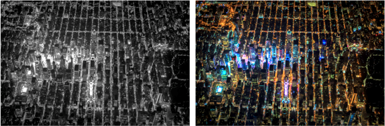
Fig. 7: As cores encontram sua própria paleta de tons, tornando-se mais diversificadas e contrastantes na passagem das escalas cinza para as coloridas, levando a um enorme aumento nas possibilidades combinatórias. Foto: Vincent Laforet. Fonte: Acervo pessoal dos autores, 2019.
Muitos estudos em ciência cognitiva e informação espacial têm afirmado associações entre características físicas e conteúdos semânticos nas cidades. Certos processos cognitivos desencadeiam associações com elementos do ambiente através da incorporação de informação socialmente adquirida (TAYLOR, et al., 2011). A informação é classificada em categorias compartilhadas pelas pessoas (ROSCH, 1978). A probabilidade de um edifício ou lugar evocar uma representação mental compartilhada é reforçada pela sua aparência e identidade visual, juntamente com sua visibilidade e localização no ambiente e com a informação social associada às atividades realizadas lá (GOLLEDGE, 1992).
Mas como a informação ambiental semântica importa para nossas ações? Associações semânticas com lugares aumentam o poder do meio ambiente em nos informar (TAYLOR, et al., 2011; MCNAMARA, et al., 1992). Por exemplo, nos lembramos de um restaurante mais facilmente, se sabemos que ele está localizado perto de certa ou de outro restaurante. Padrões locacionais como esse funcionam cognitivamente: atividades de um mesmo setor frequentemente estarão localizadas próximas umas das outras, competindo ou estabelecendo formas de complementaridade, atraindo mais atenção do que se estivessem dispersas e isoladas.
A similaridade semântica já foi proposta como medida (MÜLLIGANN, et al., 2011). Argumentamos que outro ponto chave seria medir a diversidade de conteúdos sociais em edifícios e lugares. Propomos lidar com esses significados compartilhados por meio de mapas semânticos (TVERSKY, 1993). Mapas semânticos podem representar qualquer forma de conteúdo social no espaço urbano, incluindo no espaço público, como uma esquina com a presença de vendedores ambulantes, por exemplo. Os mapas podem não capturar interpretações e memórias individuais dos lugares, mas podem capturar seus significados compartilhados.
Esses significados fazem parte do nosso conhecimento de uma cidade e seu mundo social, e apoiam nossa compreensão do papel dos lugares no apoio a nossas ações e interações. Como qualquer tipo de conhecimento social e ambiental, ele deve ser construído heuristicamente, a partir de situações cotidianas. Para simplificar, escolhemos categorias clássicas em estudos urbanos: usos do solo variando de praças públicas a edifícios residenciais na nossa análise de duas áreas urbanas (Figura 8, à esquerda).
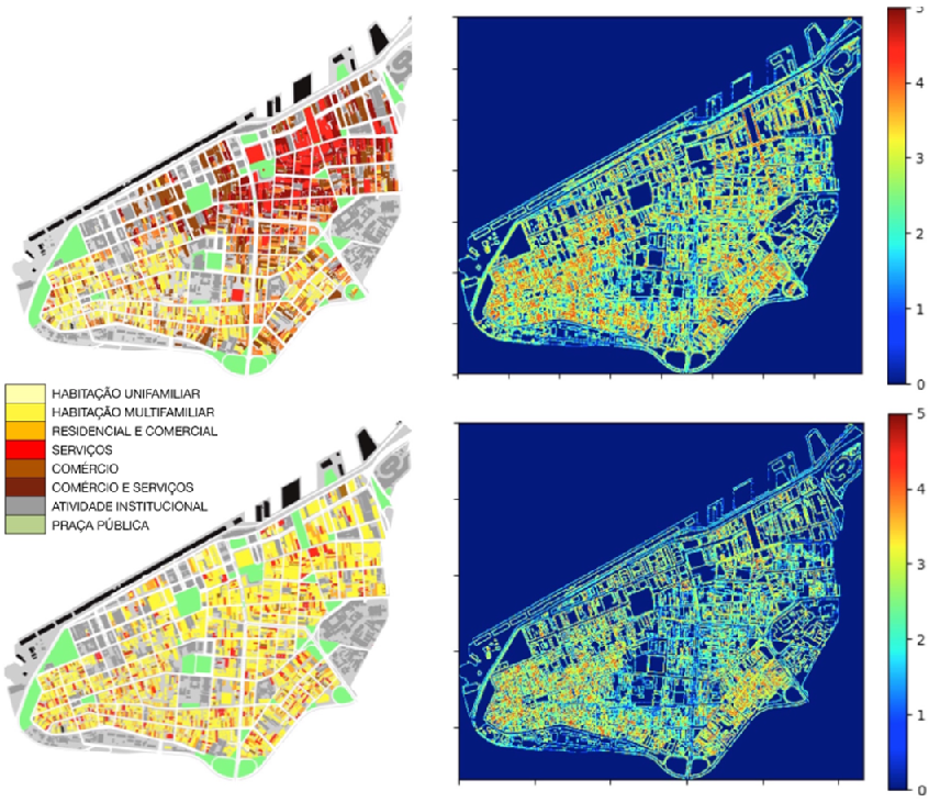
Fig. 8: Mapas semânticos: distribuição real (acima, esquerda), levantada por Maraschin (2014), e distribuição fictícia (abaixo, esquerda) dos usos do solo no centro de Porto Alegre. Os valores mostrados à direita (do azul para vermelho) mostram os níveis de diversidade entre células de usos do solo. Fonte: Autores, 2019.
A informação semântica pode ser medida como níveis de diversidade encontrados nas distribuições de uso do solo, uma forma de informação potencialmente atrativa para os agentes, analisando as adjacências locais entre edifícios ou células vizinhas. Temos de fazer isso usando um procedimento diferente do usado para analisar informação 1. Definimos um bloco de células correspondente a um quadrado. Dentro deste quadrado, medimos a distribuição dos usos do solo pela frequência dos diferentes usos. Por exemplo, em ambos os casos na Figura 8, há 8 tipos de uso do solo. Então estimamos o valor de informação para cada área. A análise gráfica identifica arranjos de alta diversidade nos mapas, correspondendo às interfaces entre usos do solo. A distribuição real é mais diversa do que a fictícia, sugerindo que suas células codificam mais informação semântica. Estes exemplos mostram a utilidade do método para capturar níveis de informação 2 em distribuições de conteúdos sociais nas cidades.
5 Informação 3: prática
Finalmente chegamos ao problema de como as pessoas usam a informação ambiental 1 e 2 para agir e interagir. Chamamos isso de “informação prática” ou informação 3. Essa informação trocada pelas pessoas a partir do que elas decodificam do ambiente vem sendo tratado como "enação" em estudos cognitivos, como em Varela et al (1991). A enação é “incorporada” no sentido de que nossa cognição depende da experiência de corpos com capacidades sensório-motoras “situadas” em um contexto biológico, psicológico e cultural mais abrangente.
Neste ponto, chegamos a um problema fundamental nas abordagens enativas: como a coordenação surge entre os agentes? A emissão e recepção de sinais na linguagem dá origem à modulação e coordenação entre nossas ações. Há comunicação efetiva somente se as interações resultarem nessa coordenação (STEWART, et al., 2010). Nesse ponto, entra o papel do ambiente construído e da informação ambiental. Edifícios e lugares mediam nossas interações. A camada semântica de informação ambiental oferece à camada 'enativa' um meio de estabelecer pontos em comum, um sistema de referências com uma granulação fina para podermos transmitir significados na nossa comunicação, e para podermos conectar nossas ações. Os lugares se tornam nós entre nossas ações.
Essas conexões acabam progressivamente levando a verdadeiras redes de interações entre lugares e pessoas e o que elas fazem juntas. Um espaço fisicamente e semanticamente estruturado se torna um referencial, uma forma de organização tangível para as interações.
Pense em um lugar onde você vai em sua vida cotidiana – digamos, em uma rua movimentada perto do seu trabalho. Você não vai até esse lugar arbitrariamente ou aleatoriamente. O ambiente físico e semântico ‘informou’ a você (ou ao navegador no seu smartphone) que esse lugar existe, e que era uma possibilidade para a sua ação, um meio de participar dessa situação. O ambiente físico e semântico tem um papel ativo no modo como você e outras pessoas conseguem atuar juntas, coordenando suas ações.
Além disso, essa situação pode ser extrapolada para outras. O que acontece lá tende a ter efeitos em cascata, com ações e seus resultados se conectando a outras ações e lugares, fundindo-se em uma enorme rede de interações que se desdobra em escalas cada vez maiores através de diferentes meios de comunicação e que estrutura o mundo ao seu redor, incluindo sua cidade e eventualmente outras cidades e regiões do seu país e do mundo. A informação ambiental torna-se um meio elementar de organização social – ou um meio de reduzir entropia. Essa ideia é consistente com as abordagens enativas: as pessoas se apoiam na informação ambiental para cooperar.
Mas há mais papéis para o ambiente em nossas interações. Imagine agora um problema sobre o qual raramente pensamos: como escolhemos as pessoas ou as atividades com as quais queremos interagir? Dado o enorme número de possibilidades de interações em uma cidade, como ambiente construído pode nos informar e nos ajudar a selecionar lugares e realizar interações?
Uma das coisas a saber aqui é se os diferentes padrões, como a acessibilidade física (informação 1) ou a distribuição das atividades no espaço (informação 2) afetam nossas escolhas e a combinação entre nossas ações. Por exemplo, diferentes níveis de diversidade das atividades podem ter efeitos diferentes nas ações das pessoas. Propomos avaliar as possibilidades de combinações de ações em diferentes cenários espaciais, como os da Figura 9.
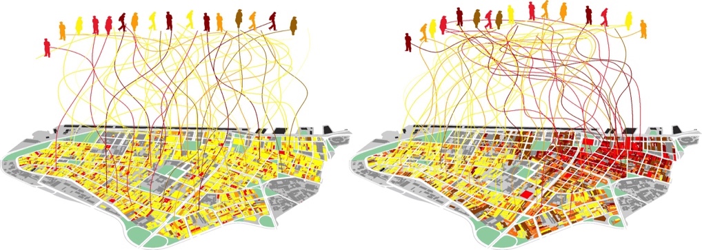
Fig. 9: O arranjo semântico influencia a coordenação das nossas ações? Agentes convergem em uma distribuição fictícia, quase aleatória (esquerda), e em uma distribuição real e padronizada (à direita). Fonte: Autores, 2019.
Uma maneira de fazer isso é quantificar a informação ambiental disponível para as pessoas e suas decisões. Testamos essa ideia através de um modelo computacional (NETTO, et al., 2017). Nosso modelo é baseado em agentes (agent-based model, ABM) e inclui tipos de ação, localizações espaciais e temporais, situações (representadas por lugares de atividade) e parâmetros do comportamento do agente, como a capacidade de procurar e identificar situações sociais, tomar decisões baseadas em orientações pessoais, e mudar suas ações e o próprio ambiente semântico.
Por simplicidade, nosso modelo usa uma cidade fictícia, uma estrutura em anel capaz de representar os aspectos mínimos da informação ambiental 1 (a distância física entre lugares ou células) e informação 2 (as diferenças no conteúdo social dos lugares ou células). A forma anelar desta cidade permite o movimento contínuo através de uma sequência de lugares, eliminando fatores de centralidade, efeitos de borda e o papel da topologia.
Nossa hipótese é a de que (a) a proximidade física, parte da informação 1, tende a estimular as interações dos agentes (ALLEN 1977), e (b) a diversidade das atividades, parte da informação 2, aumenta o potencial de coordenação e cooperação entre os agentes, levando a reduções na entropia social.
Em cada iteração do modelo, os agentes selecionam e visitam uma célula específica dentro da cidade. A decisão sobre qual ação realizar pode ser influenciada por três condições diferentes: (i) a orientação latente, a tendência de um agente agir em torno de um tipo de ação baseado em memórias de longo prazo. Essa orientação é inicialmente distribuída aleatoriamente aos agentes, e ela permanece ao longo da simulação. (ii) A ação recente executada pelo agente enquanto ele seleciona um lugar de atividade para realizar uma nova ação. A influência da ação recente abre a possibilidade de mudanças de orientação no tempo. (iii) Lugares de atividades onde os agentes realizam o tipo de ação. Os agentes selecionam os lugares mais afins a suas orientações latentes e ações recentes, sendo influenciados por essas atividades. Os agentes também influenciam os lugares, mas estes mudam seu conteúdo em um ritmo mais lento. Isso quer dizer que os agentes co-evoluem com seu ambiente semântico.
O modelo então analisa a probabilidade de encontrarmos diferentes tipos de ação. No limite, quando a entropia cai para zero, todos os agentes no sistema alcançariam a mesma ação. No outro caso extremo, o de máxima entropia, os tipos de ação são tão variados que indicam pouca cooperação entre os agentes. Testamos dois tipos de cenários: um em que a proximidade entre as células (um aspecto da informação física) não é importante para os agentes em suas decisões (linha azul na Figura 10) e outra em que é importante (linha vermelha).
A Figura 10 mostra a distribuição de probabilidade dos diferentes tipos de ação no início (à esquerda) e no final (à direita) das simulações. O cenário em que os agentes escolhem os lugares para ir a partir da proximidade entre as células de atividade aumenta dramaticamente a cooperação. É como se os agentes aprendessem a flexibilizar seus interesses, aprendendo a coordenar suas ações a partir dos lugares que escolhem e os aproximam em torno de certos tipos de ação. Chegamos a esses resultados a partir de 30 execuções para cada uma das 125 combinações de parâmetros ( NETTO, et al., 2017).
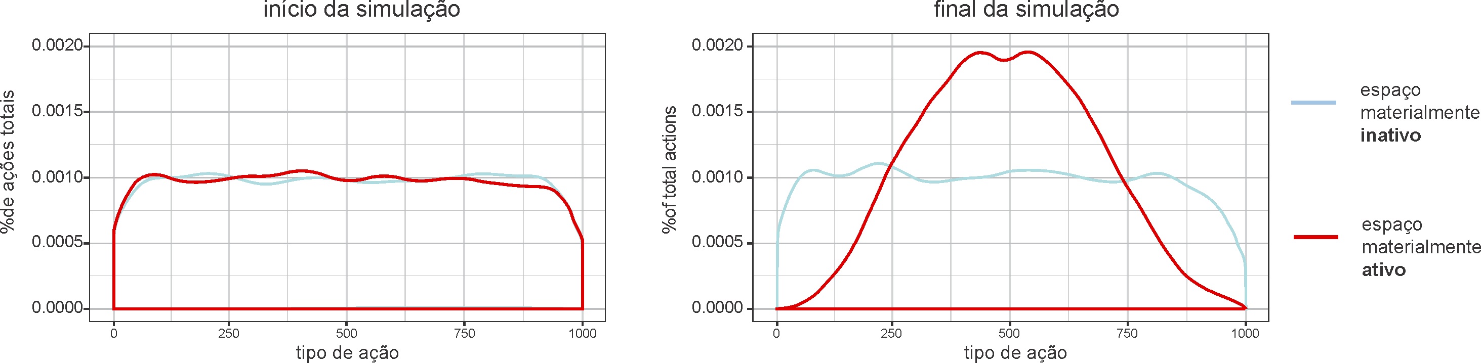
Fig. 10: Entropia nas interações: as distribuições de probabilidade dos tipos de ação mostram altos níveis de entropia no início das simulações (esquerda) em dois cenários: onde a distância entre lugares de atividade não é considerada (linha azul) e onde a distância é considerada (linha vermelha). No final das simulações (à direita), o cenário onde a distância física importa mostra convergência dos agentes em torno de certos tipos de ação, indicando cooperação a partir dos lugares de atividade. Fonte: Autores, 2019.
O modelo mostra que, quando agentes usam o critério da proximidade física na seleção de atividades, o espaço se torna um meio para estimular a cooperação. A informação ambiental “contamina” os agentes: eles tendem a alinhar suas ações através do conteúdo informativo dos lugares. Isso quer dizer que a probabilidade de certas interações aumenta. Em termos práticos, isso significa mais alinhamentos entre os agentes. Como um ambiente de informação, o ambiente físico e semântico cria diferenças nas probabilidades de interação, ajudando a resolver o problema combinatório de conectar ações na forma de um sistema.
6 Cidades como informação: observações finais
Neste artigo, buscamos entender como analisar a informação contida no ambiente físico e semântico, e entender como humanos usam essa informação ambiental para coordenar suas ações. Trabalhos anteriores trataram apenas de aspectos dessas relações, como a informação espacial relacionada à cognição e navegação e redes sinérgicas como base para ações na cidade, sem o aspecto sistêmico da interação.
Para ligarmos a informação ambiental à interação dos agentes com o espaço, abordamos três questões: (i) Como codificamos e decodificamos informação no ambiente físico? (ii) Como o espaço físico ganha significado? (iii) Como usamos informação ambiental para coordenar nossas ações? Exploramos diferentes vertentes da teoria da informação e estudos cognitivos para propor (a) um modelo teórico de três camadas de informação nas cidades; (b) medidas de informação em cada uma camadas; (c) um modelo computacional baseado em agentes para simular como aspectos da informação ambiental afetam a cooperação. Mais especificamente:
1. Analisamos a informação ambiental 1 nos arranjos celulares a partir da medida de entropia de Shannon, aplicada em casos empíricos selecionados de diferentes regiões.
2. Analisamos a informação ambiental 2 como uma função da diversidade semântica nas relações locais entre atividades urbanas ou usos do solo. A informação 2 é altamente diferenciada, servindo como um recurso de grande poder no processo de seleção e combinação de lugares e ações a serem realizadas.
3. Modelamos a influência do ambiente na informação 3 como tipos de ação em um ABM. A proximidade em configurações físicas (aspecto da informação 1) e os conteúdos semânticos no espaço (aspecto da informação 2) estimulam a convergência de tipos de ação entre agentes. Nosso modelo mostra que aspectos da informação ambiental no espaço físico e semântico contribuem para o aumento da coordenação das ações dos agentes nos sistemas de interação. A entropia das ações diminui à medida que os agentes co-evoluem com seu ambiente. Até onde sabemos, nenhum outro trabalho integra cognição, ambiente e sistemas sociais dessa forma abrangente.
Sociedades, enquanto sistemas de interação, precisam de uma alta capacidade para acessar e recombinar informação. Elas são "famintas por informação". Essa dependência demanda diferentes tipos de informação. Em que pese a adição de novas redes de transmissão de informação, como as digitais, algo ainda a ser verificado empiricamente, a informação ambiental parece ter um papel importante na criação e coordenação das nossas interações locais. O fato de as cidades preservarem informação social em seus espaços físicos e em suas estruturas semânticas seria uma parte elementar desse processo, e esse papel merece mais investigação. Somente por meio de uma estrutura que restrinja as possibilidades combinatórias quase infinitas da interação, um sistema pode adquirir estrutura interna suficiente para possibilitar sua própria reprodução.
A cidade nos ajudaria a converter um tremendo volume de informação em interação. Na verdade, nossa cognição, o ambiente e ações mostram ter uma conexão profunda. Esses sistemas parecem co-dependentes – e mais. Eles parecem se moldar mutuamente e emergir como um sistema completamente híbrido – mas integrado. Esta integração de mentes, cidades e sociedades só poderia acontecer através da informação. Informação é a ponte.
Referências
ALLEN, T. Managing the Flow of Technology. Cambridge, MA: MIT Press, 1977.
BATES, M. Fundamental forms of information. J. Am. Soc. Inf. Sci. Technol., v. 57, p. 1033-1045, 2006.
BOLTZMANN, L. On the relationship between the second fundamental theorem of the mechanical theory of heat and probability calculations regarding the conditions for thermal equilibrium. Entropy, v. 17, p. 1971-2009, 2015. 1. ed. 1873.
GARLANDINI, S.; FABRIKANT, S. I. Evaluating the effectiveness and efficiency of visual variables for geographic information visualization. In: International Conference on Spatial Information Theory. Nova Iorque: Springer, 2009. p. 195-211.
GOLLEDGE, R. G. Place recognition and wayfinding: Making sense of space. Geoforum, v. 23, p. 199-214, 1992.
HABERMAS, J. The Theory of Communicative Action. Cambridge, UK: Polity Press, 1984.
HAFTING, T.; FYHN, M.; MOLDEN, S.; MOSER, M. B.; MOSER, E. I. Microstructure of a spatial map in the entorhinal cortex. Nature, v. 436, p. 801-806, 2005.
HAKEN, H.; PORTUGALI, J. Information Adaptation: The Interplay Between Shannon Information and Semantic Information in Cognition. Nova Iorque: Springer, 2015.
HIDALGO, C. Why Information Grows: The Evolution of Order, from Atoms to Economies. Nova Iorque: Basic Books, 2015.
HILLIER, B. Space is the Machine. Cambridge, UK: Cambridge University Press, 1996.
HUTCHINS, E. Cognition in the Wild. Cambridge, MA: The MIT Press, 1995.
LAKOFF, G.; JOHNSON, M. Philosophy in the Flesh. Nova Iorque: Basic Books, 1999.
LYNCH, K. The Image of the City. Cambridge, MA: The MIT Press, 1960.
MARASCHIN, C. Dinâmica e resiliência das áreas comerciais: uma abordagem configuracional em Porto Alegre. Porto Alegre: UFRGS, 2014.
MCNAMARA, T. P.; HALPIN, J. A.; HARDY, J. K. The representation and integration in memory of spatial and nonspatial information. Mem. Cogn., v. 20, p. 519-532, 1992.
MÜLLIGANN, C.; JANOWICZ, K.; YE, M.; LEE, W. C. Analyzing the spatial-semantic interaction of points of interest in volunteered geographic information. International Conference on Spatial Information Theory. Nova Iorque: Springer, 2011. p. 350-370.
NETTO, V. M.; MEIRELLES, J.; RIBEIRO, F. Social interaction and the city: The effect of space on the reduction of entropy. Complexity, v. 2017, 2017.
NETTO, V. M.; BRIGATTI, E.; MEIRELLES, J.; RIBEIRO, F. L.; PACE, B.; CACHOLAS, C.; SANCHES, P. Cities, from information to interaction. Entropy, v. 20, n. 11, p. 834, 2018. Disponível em: <https://doi.org/10.3390/e20110834>. Acesso em: ago. 2019.
NETTO, V. M.; BRIGATTI, E.; CACHOLAS, C.; GOMES, V. Assessing Spatial Information in Physical Environments. In: INTERNATIONAL CONFERENCE ON SPATIAL INFORMATION THEORY (COSIT), 14., 9-13 set. 2019, Regensburg-Alemanha. Proceedings...
PRIGOGINE, I.; STENGERS, I. Order out of Chaos: Man’s New Dialogue with Nature. Nova Iorque: Bantam Books:, 1984.
ROSCH, E. Principles of categorization. In: Cognition and Categorization. Hillsdale, NJ: Lawrence Erbaum Associates, 1978. p. 27-48.
SHANNON, C.E. Communication theory of secrecy systems. Bell Syst. Tech. J., v. 28, p. 656- 15, 1948.
SHANNON, C.E.; WEAVER, W. The Mathematical Theory of Communication. Champaign: The Illinois University Press, 1949.
STEWART, J.; STEWART, J. R.; GAPENNE, O.; PAOLO, E. A. D. Enaction: Toward a New Paradigm for Cognitive Science. Cambridge, MA: The MIT Press, 2010.
TAYLOR, H.; WANG, Q.; GAGNON, S. A.; MADDOX, K.; BRUNYÉ, T. The social connection in mental representations of space. In: INTERNATIONAL CONFERENCE ON SPATIAL INFORMATION THEORY (COSIT), 2011Berlim/Heidelberg. Proceedings...
TVERSKY, B. Cognitive maps, cognitive collages, and spatial mental models. In: CAMPARI, I.; FRANK, A. (Eds.) European Conference on Spatial Information Theory. Nova Iorque: Springer, 1993. p. 14-24.
VARELA, F.; THOMPSON, E.; ROSCH, E. The Embodied Mind: Cognitive Science and Human Experience. Cambridge, MA: The MIT Press, 1991.
WEAVER, W. Recent contributions to the mathematical theory of communication. In: The Mathematical Theory of Communication. Champaign, IL: The Illinois University Press, 1949. p. 1-28.
Cities as information
Vinicius Netto holds a degree in Architecture and Urbanism and a Ph.D. in Advanced Architectural Studies, and is an Associate Professor at the Fluminense Federal University, Brazil. He develops and guides research on the City as segregation networks, Information networks, and Material interaction networks. He is the author of the books The Social Fabric of Cities (2017) and City & Society (2014), and co-organizer of the books The Effects of Architecture (2017) and Urbanities (2012).
Edgardo Brigatti is a graduate and Ph.D. in Physics and an Assistant Professor at the Federal University of Rio de Janeiro, Brazil. He works on Physics of Complex Systems, in particular on interdisciplinary studies applied to the biological, social and economic sciences.
João Meirelles holds a degree in Environmental and Water Resources Engineering and a Master's degree in Complex Systems Modeling. He is a researcher at the Ecole Polytechnique Fédérale de Lausanne, Switzerland, where he studies the dynamics of urban metabolism, using data analysis, mathematical modeling, and simulations.
Fabiano Ribeiro is a graduate and Ph.D. in Physics, with a Post-doctorate in Statistical Physics. He is an Adjunct Professor at the Department of Physics at the Federal University of Lavras, Brazil. He studies statistical physics, complexity, and city science.
Caio Cacholas is an Architect and Urbanist, Master in Architecture and Urbanism and a member of the City and Information research group in the Graduate Program in Architecture and Urbanism of the Fluminense Federal University, Brazil. He studies the impacts of urban morphology on the setting of public spaces and works on urban design and computer programming.
How to quote this text: Netto, V. M., Brigatti, E., Meirelles, J., Ribeiro, F. L. and Cacholas, C., 2019. Cities as information. V!rus, Sao Carlos, 19. [e-journal] [online] Available at: <http://www.nomads.usp.br/virus/virus19/?sec=4&item=1&lang=en>. [Accessed: 01 July 2025].
ARTICLE SUBMITTED ON AUGUST 28, 2019
Abstract
From physics to social sciences, information today is seen as a fundamental aspect of reality. However, one form of information still seems underestimated, perhaps precisely because it is so present. We do not fully understand how cities materialize information, and how our minds deal with this environmental information to learn about the world, make decisions, and participate in the complex system of social interactions. This paper addresses three issues that need to be addressed if we are to understand the role of environmental information: (1) the physical problem: how can we preserve information in the built environment? (2) the semantic problem: how can physical form convey meaning? (3) The pragmatic problem: How do we use environmental information in our daily lives? Looking for answers, we introduced a three-layered model of information in cities, namely: environmental information in physical space, environmental information in semantic space and practical information exchanged by agents. We propose ways to estimate information in these different layers and apply these measures in simulated scenarios and in emblematic cities in different regions of the world. Our results suggest that spatial structures and land use patterns encode information and that aspects of physical and semantic information affect coordination in interaction systems.
Keywords: Information, Cities, Interaction, Environmental information, Entropy
1 Introduction: complex systems in relation
Look out of your window. You will see differences in the shapes and sizes of buildings, some perhaps taller and more concentrated in certain parts of the city. You will find that these buildings are connected to the streets and that they are probably also different from each other. Even if you have never been to this city or area before, you can walk through it and find someone or something you need on a busy street. You can situate yourself and find your way. You never thought about it, but this is a condition for being where you are right now. In fact, you live within a pattern: the interaction of recognizable relationships and variations between spaces, a mix between hierarchy and contingency, a balance between order and surprise. Because these patterns involve tangible spaces, people's activities, and their ability to do things together, this is both material, cognitive, and social interaction —all at once. You live the interaction of minds, cities, and societies. Although each of these systems is complex in itself, the interesting thing is that they eventually relate. Working together, minds, cities, and societies somehow "merge" into one immensely interactive system.
This article deals with how we use information in our environment to act collectively on this hybrid system. It deals with the mutual construction of information, both in the environment and in our perception and in the 'weaving of social life'. We will see the city as layers of environmental information essential for human interaction and cooperation. To this end, it explores various theories such as information, cognition, and social systems. For example, we learn from cognitive science about how humans relate to information in their environment. Various approaches claim that our minds not only decode environmental information but also extend to the environment (Varela et. al., 1991; Lakoff and Johnson, 1999). We want to explore possibilities related to this idea: how information is preserved in the built environment and how this information supports our interactions.
This means exploring the transition from information to interaction. This transition seems to be at the heart of a big problem: How do we connect our actions to create a society? How can individual actions develop into a coherent system of interactions? How do we coordinate the individual decisions of huge numbers of people? Let us argue here that the way we organize ourselves in society depends crucially on how we deal with information in our environment.
How does this happen? One thing that minds, cities, and societies have in common is information. They depend on it. Minds process information. Societies exchange information to exist. The built environment has structures that can contain information. These systems process, share and preserve information. Was information the bridge between them?
Understanding the connections between minds, cities, and societies requires several methodological steps. First, let's introduce a conceptual model of 'city as information' in three layers. Then we will propose information measures for these layers, and apply them to selected urban cases from different regions of the world, and to simulated scenarios.
2 From information to interaction
The seminal book by Shannon and Weaver (1949) stimulated most discussions about information. Interestingly, Weaver offers a way to understand the relationship between our minds, environment, and interaction by asking three questions: “(A) How accurately can symbols of communication be transmitted? (the technical problem). (B) How accurately do symbols convey the desired meaning? (the semantic problem). (C) Does the meaning received affect the conduct as desired? (the problem of effectiveness)”. The relationship between cognition, environment, and interaction involves analogous questions:
1. How do we encode and decode information from the environment? (the physical problem)
2. How can physical space convey meaning? (the semantic problem)
3. How does environmental information affect our actions? (the pragmatic problem)
We will see that information is somehow embedded in tangible spatialities that humans create as their environment. In turn, semantic information is created as meaningful content in buildings and places associated with certain activities. We seem to recognize places as configurations related to our actions and a shared idea of what they are. Finally, the pragmatic problem involves how we use environmental information to guide our actions and create interactions. We propose to deal with these forms of information in three interactive and overlapping layers (Figure 1).
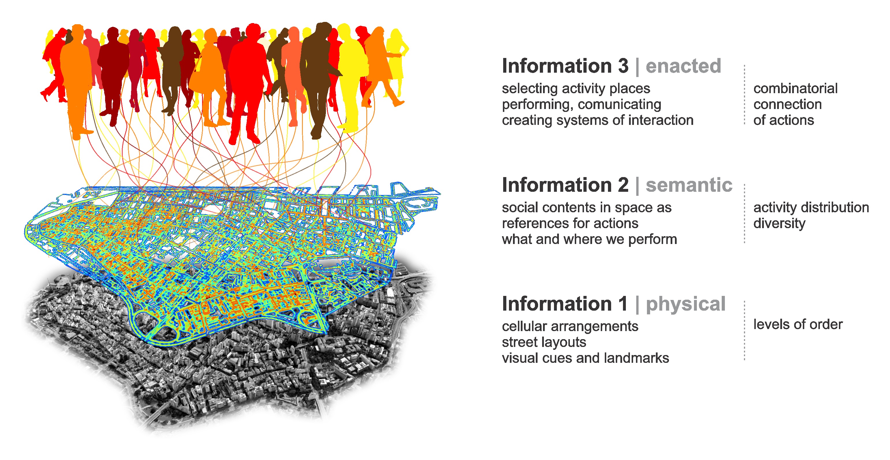
Fig. 1: Environmental information (1) physical space and (2) semantic space and staged information (3): substantive components and measurable properties. Source: Authors.
Classical theories deal with these forms of information to different extents. For example, Lynch's “city image” (1960) operates primarily at information level 1, as it deals with physical paths and clues related to cognition and navigation. Hillier's (1996) spatial syntax apprehends accessibility patterns in street networks related to cognition, movement, and encounter. The synergistic inter-representation networks of Haken and Portugali (2015) unite Shannon and semantic information as the basis for actions in the city, but without the systemic aspect of social interaction.
Our theoretical model places the physical layer at the bottom as the elementary and fundamental layer of information related to our cognition and navigation. The layer includes the arrangement of elements such as buildings and streets and the relationships between them. In addition, it is a very stable form of information that changes slowly. In turn, the semantic layer has to do with how buildings and places support our actions. Its stability depends on how long actions are performed in these places and how long their meanings are retained in people's memories, so it changes more easily.
Environmental information 1 and 2 are inseparable, but not necessarily intrinsic to each other. Although a building is designed to support a certain activity, it can be used for different activities over time, sometimes without the need for physical adaptation (for example, a house becomes a store or an office). Thus, physical information tends to remain, while semantic information depends on the ongoing actions and memories provided by the building. Finally, practical information layer 3 includes the effects that places and their meanings have on agents, bringing possibilities of action (Kuppers, 2013). Actions include speech, body gestures, and the production of signs and objects that carry meaning, and are therefore understandable by other agents, triggering interactions (Habermas, 1984). Information 3 is created in the transition between cognition, environment, and interaction. It involves environmental information whenever we use the environment around us to make individual decisions, act and communicate.
Now let's look at what each layer individually is and how they interact like a single system, uniting minds, cities, and societies (Figure 2). The environment we humans create is made up of tangible and non-tangible structures, an interaction of physical spaces (environmental information 1) and configurations of meanings in spaces and places (environmental information 2). People ('agents') encode information and decode environmental information and relate to it via perception and cognition. In turn, cognition is situated because it extends to action and arises from interactions between agents and their environment. Cognition emerges from interactions as distributed processes in collective operations between agents (Hutchins, 1995). As we shall see, this extension of cognition in the environment and the way agents coordinate their actions is the definition of “enation” (Varela et. al., 1991), or what we call practical information 3. Information 3 encompasses perception, cognition and situated interactions and is deeply related to their environment.
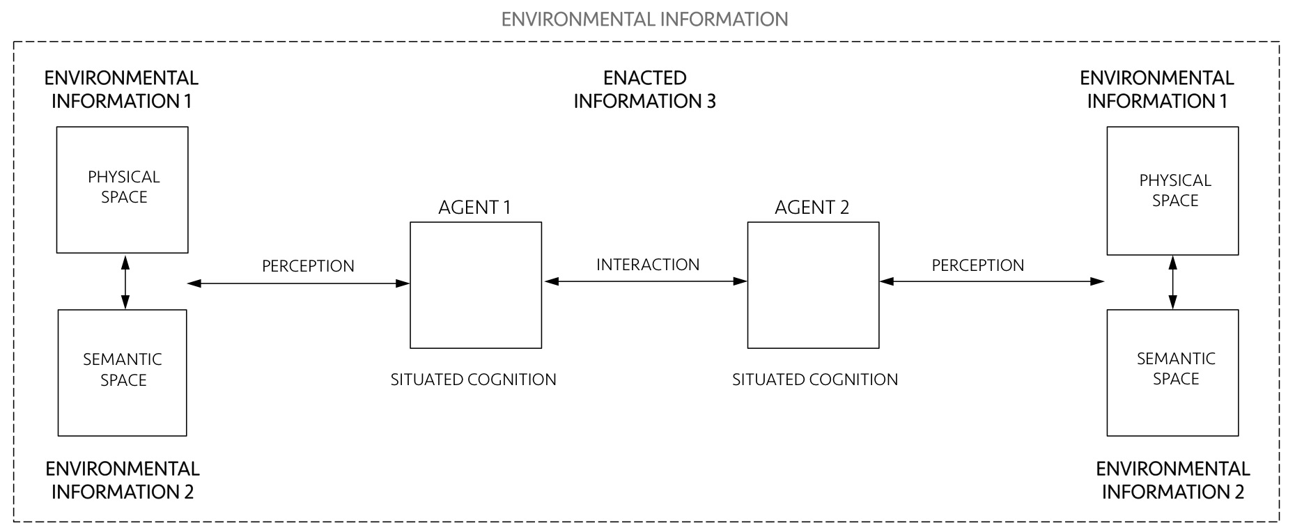
Fig. 2: Schematic diagram of a general information-interaction system. Source: Authors.
Of course, all of these items and relationships have been heavily researched and need detailed definitions. We will approach them following the conceptual architecture of the three layers.
3 Environmental information 1: the physical space
Since Shannon's (1948) pioneering work on the mathematical theory of communication, the notion of information took on other disciplines in the 1950s and 1960s. Shannon came to a clear description of information through a probabilistic definition of entropy, also explored by physicist Boltzmann (2015 [1873]) before him. For both, entropy is a measure of the uncertainty of a system. The greater the number of potentially transmitted messages (Shannon, 1948) or the number of distinct microscopic states of a thermodynamic system (Boltzmann, 2015 [1873]), the greater the corresponding entropy. Since Boltzmann, entropy has been associated with the disorder (Prigogine and Stengers, 1984). Higher entropy physical arrangements are characterized by higher levels of randomness, unpredictability or uncertainty. In turn, predictability levels may be associated with the order. Ordered structures contain correlations such as similarities, consistencies, and associations that may be seen as the “substance” of information, as pieces of “coherence above and beyond grouping and dispersing entities” (Bates, 2006, p.1034).
The fact that information can be encoded in physical structures is interesting. Information lasts longer when preserved in tangible entities (Hidalgo, 2015). If physical spaces materialize information, we have a way of expressing information continuously as long as these spatialities exist. We can encode information in the built environment and decode it while we live in it. This would open extraordinary cognitive possibilities to guide our actions.
But how can we encode information in the built environment? At this point, there seems to be no definitive answer to this question. Research in the field of spatial information seems to focus mainly on how we decode environmental information - for example, the role of perception and visual elements in navigation and spatial decision making (Garlandini and Fabrikant, 2009). Empirical work in neuroscience confirms that neural algorithms 'integrate' information about place, distance, and direction, forming topographically oriented and neural maps of the spatial environment. "Grid cells" in the brain are activated whenever our position coincides with vertices of a regular hexagonal grid spanning the surface of the environment, being critical to our goals and navigation plans (Hafting et al. 2005).
One possibility under increasing attention in this field is that levels of regularity, alignment, and predictability in spatial arrangements are cognitively useful for anchoring our internal navigation system (see Ekstrom et. al, 2018). We can capture levels of physical information by recognizing the regularity of spatial event frequencies in the environment. If this is the case, the greater the variation of elements in the environment, the lower the regularities that would allow us to understand more quickly and make inferences about the space around us. But which spatial arrangements contain more physical information?
We suggest that one way people create information 1 is by generating levels of order in the deepest elements of the built form: the aggregations of buildings shaping urban space. Imagine the projection of buildings in a two-dimensional space in the form of a grid. Buildings take the form of cells and occupy positions in this grid, making arrangements as in Figure 3. These arrangements display different levels of order, apparent in the frequency of distances between cells. An extreme case is an orthogonal arrangement (Figure 3, case 1). Perfectly regular arrangements like this are rare situations in the set of possible arrangements - like drops of order in a sea of disordered states. In most states, the distribution of cells tends to contain a few internal correlations, as in the second case.
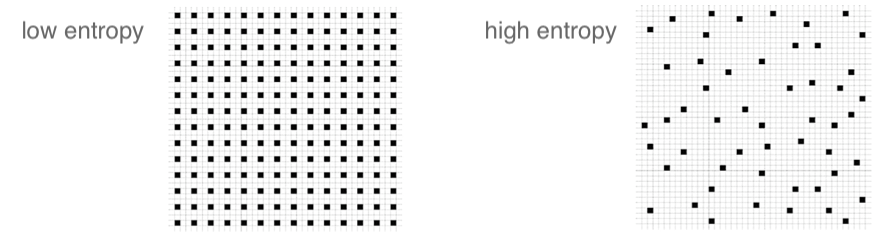
Fig. 3: Information in physical space: arrangements with different levels of entropy. Source: Authors.
We propose to analyze the predictability levels in physical arrangements using statistical concepts. An information measure 1 should be able to grasp regularities and variations in actual configurations and different urban situations. For this purpose, we suggest using Shannon's entropy (1948). As we have seen, high entropy corresponds to high levels of randomness or unpredictability. In contrast, the presence of regularities and patterns in urban structures corresponds to the lowest entropy. Hypothetically, cities with orderly structures would help agents understand their environment by allowing them to make predictions about areas beyond their field of visibility. People can make inferences, memorize layouts, and navigate more easily from one place to another - say, by grasping the pattern of blocks and intersections of local streets and inferring the structure of the surrounding blocks.
The measure of spatial entropy can be explored to characterize urban areas and cities from different regions of the world. This is what we did for emblematic empirical cases (figure 4). We are aware that some selected cases offer no evidence to validate a model. However, these empirical analyses are intended to illustrate the use of measurements, showing their utility in capturing levels of order and information in spatial arrangements. The measure of entropy should be tested for subtle variations in real urban settings.
We sampled 9,000,000m2 of geographic areas from public map repositories such as Google Maps, scaled to 10002 pixels in monochrome and converted to an array of binary values for built-up or free cells in two-dimensional space. We know that this is a reduction of real complexities, but the approach must be able to describe the urban form minimally and sufficiently - hence its reduction to cellular aggregations.
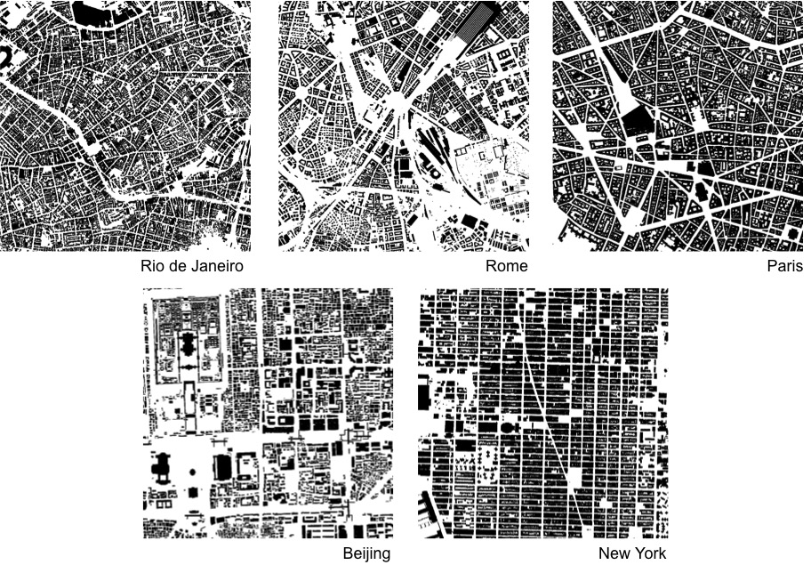
Fig. 4: Space distributions in real cities (9, 000, 000 m2, 1000 × 1000 cells) taken from Google Maps. These sections will be used to calculate Shannon entropy and to estimate the degree of disorder in cell arrangements. Source: Authors.
The analysis estimates the probabilities of distinct cell configurations and counts their frequencies in the actual structures (figure 5). For example, there are 512 different configurations for blocks with nine cells. Rio de Janeiro (Figure 5, left) shows a wide range of configurations of type (a). In turn, type (b) configurations are very common in Manhattan (figure 5, right). High repetition of the same settings approximates the entropy measure to 0, i.e. high levels of predictability. Already a low frequency of arrangements, with great variation and unpredictability means entropy levels close to 1.
Fig. 5: Information on cell arrangements. Examples of nine cell blocks are shown in red for areas in Rio and Manhattan and amplified on the right. Rio shows a wide variation of type (a) configurations indicating many irregular formations, low predictability, and high entropy. Type (b) configurations are frequent in Manhattan, containing more regular training, high predictability and low entropy. Source: Authors.
Results for estimating entropy in areas of the five selected cities are shown in Figure 6 (Netto et al, 2018; 2019). The selected north area in Rio de Janeiro shows the highest level of disorder among the cities.
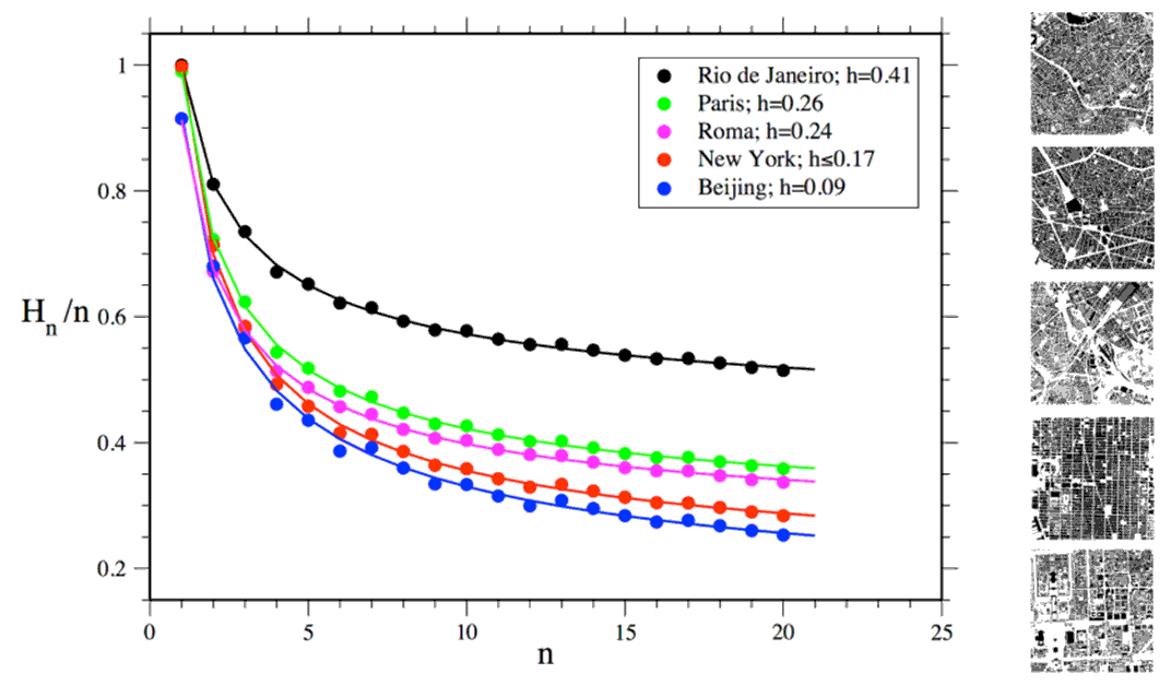
Fig. 6: Environmental information 1: Estimated entropy values for areas in five selected cities. Source: Authors.
It is interesting to note how physical information can be grasped even at small scales and that the disorder decreases as the size of the analyzed cell blocks increases, and as larger scales of order and correlation begin to matter. Levels of regularity in the physical space seem useful informational characteristics (cf. Haken and PortugalI, 2015). However, there may be a limit to the nature of the information that physical space can encode. What other aspects of the environment can preserve information?
4 Environmental information 2: the semantic space
The built environment can gain more information potential when its components assume social content and associations with people's actions. However, what is this informational potential? We can think of the difference between environmental information 1 and 2 as the difference between a black and white image and a color image. Compared to shades of gray, the colors are more diverse and contrasting. New possibilities emerge as each color meets its own palette of shades, leading to a huge increase in the combinational possibilities of colors and shades (Figure 7).
Fig. 7: Colors find their own palette of shades, becoming more diverse and contrasting in the shift from gray to color scales, leading to a huge increase in combinatorial possibilities. Photo: Vincent Laforet. Source: Personal collection of the authors.
Many studies on cognitive science and spatial information have affirmed associations between physical characteristics and semantic content in cities. Certain cognitive processes trigger associations with elements of the environment through the incorporation of socially acquired information (Taylor et.al., 2011). Information is classified into categories shared by people (Rosch, 1978). The likelihood of a building or place evoking a shared mental representation is reinforced by its appearance and visual identity, along with its visibility and location in the environment and the social information associated with the activities performed there (Golledge, 1992).
But how does semantic environmental information matter to our actions? Semantic associations with places increase the power of the environment to inform us (Taylor et. al., 2011; McNamara et. al., 1992). For example, we remember a restaurant more easily if we know that it is located near certain or another restaurant. Locational patterns like this work cognitively: activities in the same sector will often be located close to each other, competing or establishing complementarities, attracting more attention than if they were scattered and isolated.
Semantic similarity has already been proposed as a measure (Mülligann et al., 2011). We argue that another key point would be to measure the diversity of social content in buildings and places. We propose to deal with these shared meanings through semantic maps (Tversky, 1993). Semantic maps can represent any form of social content in urban space, including public space, such as a corner with street vendors, for example. Maps may not capture individual interpretations and memories of places, but they can capture their shared meanings.
These meanings are part of our knowledge of a city and its social world and support our understanding of the role of places in supporting our actions and interactions. Like any kind of social and environmental knowledge, it must be heuristically constructed from everyday situations. For simplicity, we chose classic categories in urban studies: land uses ranging from public squares to residential buildings in our analysis of two urban areas (Figure 8, left).
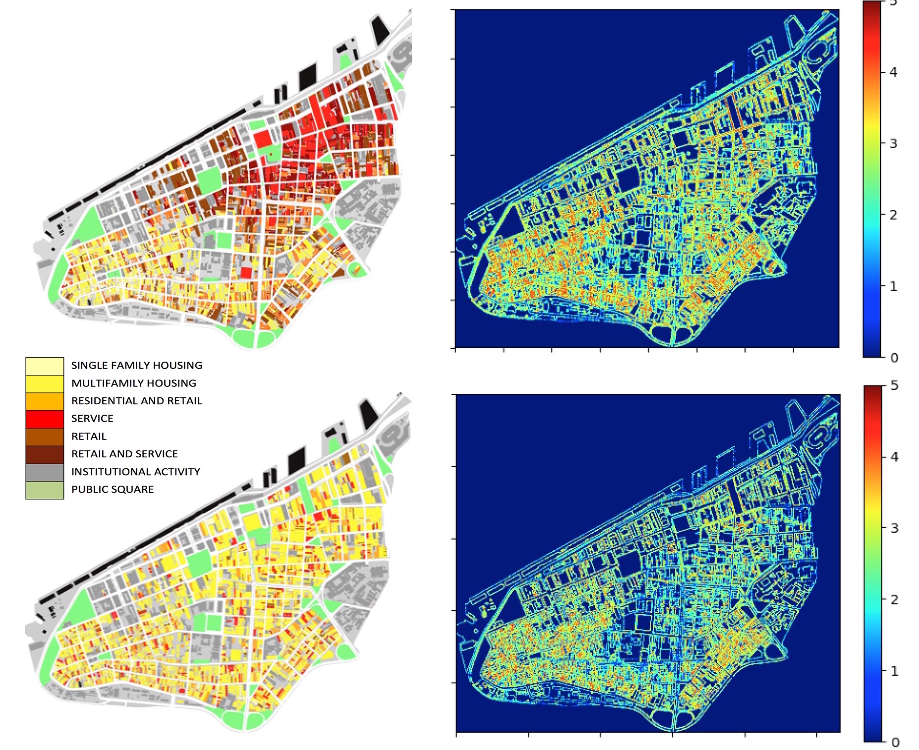
Fig. 8: Semantic maps: actual distribution (above left), as raised by Maraschin (2014), and fictional distribution (below left) of land uses in central Porto Alegre, Brazil. The values shown on the right (from blue to red) show levels of diversity between land use cells. Source: Authors.
Semantic information can be measured as levels of diversity found in land use distributions, a potentially attractive form of information for agents by analyzing local adjacencies between neighboring buildings or cells. We have to do this using a different procedure than we used to analyze information 1. We define a block of cells corresponding to a square. Within this square, we measure the distribution of land uses by the frequency of different uses. For example, in both cases in Figure 8, there are 8 types of land use. Then we estimate the information value for each area. The graphical analysis identifies high diversity arrangements in the maps, corresponding to the interfaces between land uses. The actual distribution is more diverse than the fictional one, suggesting that its cells encode more semantic information. These examples show the utility of the method for capturing information levels 2 in social content distributions in cities.
5 Information 3: enacted
Finally, we come to the problem of how people use environmental information 1 and 2 to act and interact. We call this ‘enacted information’ or information 3. This information exchanged by people from what they decode from the environment has been treated as ‘enaction’ in cognitive studies, as in Varela et al (1991). The enation is embodied in the sense that our cognition depends on the experience of bodies with sensorimotor capabilities situated in a broader biological, psychological, and cultural context.
At this point, we come to a fundamental problem in enactive approaches: how does coordination arise between people? The emission and reception of signals in language give rise to modulation and coordination between our actions. There is effective communication only if interactions result in this coordination (Stewart et al., 2010). At this point comes the role of the built environment and environmental information. Buildings and places mediate our interactions. The semantic layer of environmental information offers the enactive layer a means of establishing commonalities, a fine-grained reference system so that we can convey meanings in our communication, and to connect our actions. Places become us among our actions.
These connections progressively lead to true networks of interactions between places and people and what they do together. A physically and semantically structured space becomes a framework, a tangible form of organization for interactions.
Think of a place where you go in your daily life - say, on a busy street near your work. You do not go to this place arbitrarily or randomly. The physical and semantic environment ‘informed’ you (or informed the browser on your smartphone) that this place exists, and that it was a possibility for your action, a way to participate in this situation. The physical and semantic environment plays an active role in how you and others can act together, coordinating your actions.
In addition, this situation can be extrapolated to others. What happens there tends to have cascading effects, with actions and their outcomes connecting to other actions and places, merging into a huge web of interactions that unfolds on ever larger scales across different media and what structure the world around you, including your city and eventually other cities and regions of your country and the world. Environmental information becomes an elementary means of social organization - or a means of reducing entropy. This idea is consistent with enactive approaches: people rely on environmental information to cooperate.
But there are more roles for the environment in our interactions. Imagine now a problem we rarely think about: How do we choose the people or activities we want to interact with? Given the huge number of possibilities for interactions in a city, how can the built environment inform us and help us select places and make interactions?
One of the things to know here is whether different patterns, such as physical accessibility (information 1) or the distribution of activities in space (information 2) affect our choices and the combination of our actions. For example, different levels of activity diversity may have different effects on people's actions. We propose to evaluate the possibilities of action combinations in different spatial scenarios, such as those in Figure 9.
Fig. 9: Does the semantic arrangement influence the coordination of our actions? Agents converge on a fictitious, almost random distribution (left), and a real, standardized distribution (right). Source: Authors.
One way to do this is to quantify the environmental information available to people and their decisions. We tested this idea through a computational model (see Netto et. al., 2017). Our agent-based model (ABM) includes action types, spatial and temporal locations, situations (represented by places of activity) and parameters of agent behavior such as the ability to search and identify social situations, make decisions based on personal guidance, and change their actions and the semantic environment itself.
For simplicity, our model uses a fictional city, a ring structure capable of representing the minimal aspects of environmental information 1 (the physical distance between places or cells) and information 2 (the differences in the social content of places or cells). The ring shape of this city allows for continuous movement through a sequence of places, eliminating centrality factors, edge effects, and the role of topology.
Our hypothesis is that (a) physical proximity, part of information 1, tends to stimulate agent interactions (Allen 1977), and (b) the diversity of activities, part of information 2, increases the potential for coordination and cooperation between agents, leading to reductions in social entropy.
In each iteration of the model, agents select and visit a specific cell within the city. Deciding which action to take can be influenced by three different conditions: (i) latent orientation, the tendency of an agent to act around a type of action based on long-term memories. This orientation is initially randomly distributed to agents, and it remains throughout the simulation. (ii) The recent action performed by the agent while he selects a place of activity to perform a new action. The influence of recent action opens the possibility of changes in orientation over time. (iii) Activity locations where agents perform the type of action. Agents select places most closely related to their latent orientations and recent actions and are influenced by these activities. Agents also influence places, but they change their content at a slower pace. This means that agents co-evolve with their semantic environment.
The model then analyzes the likelihood of finding different types of action. In the limit, when entropy drops to zero, all agents in the system would achieve the same action. In the other extreme case, that of maximum entropy, the types of action are so varied that they indicate little cooperation between the agents. We tested two types of scenarios: one where proximity between cells (one aspect of physical information) is not important to agents in their decisions (blue line in Figure 10) and another where it is important (red line).
Figure 10 shows the probability distribution of the different action types at the beginning (left) and end (right) of the simulations. The scenario in which agents choose places to go from the proximity of activity cells dramatically increases cooperation. It is as if agents learn to flex their interests by learning to coordinate their actions from the places they choose and bring them closer to certain types of action. We arrive at these results from 30 executions for each of the 125 parameter combinations (Netto et. al., 2017).
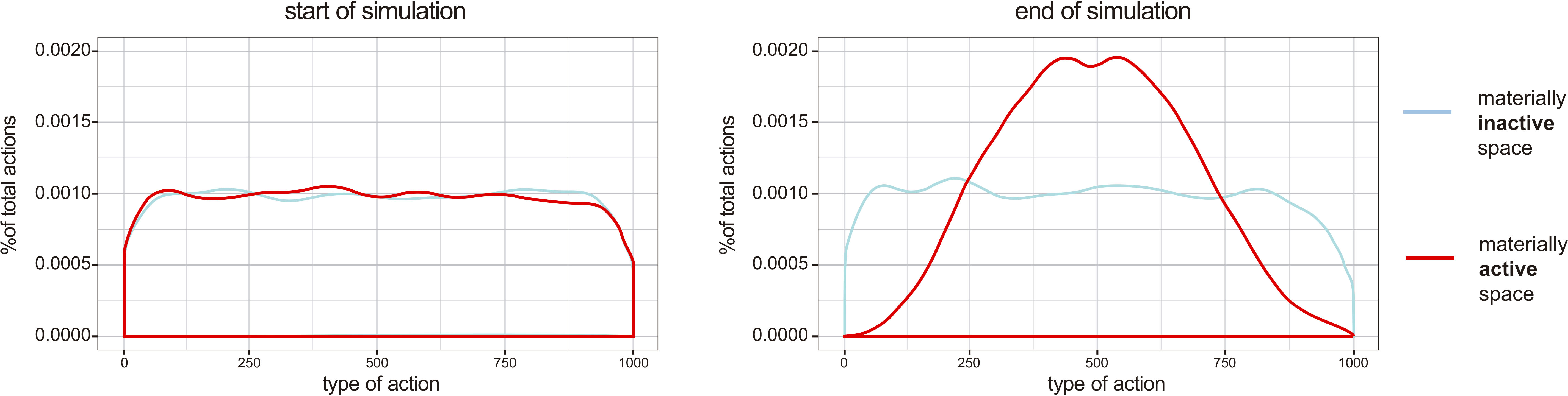
Fig. 10: Interaction entropy: The probability distributions of the action types show high entropy levels at the beginning of the simulations (left) in two scenarios: where the distance between places of activity is not considered (blue line) and where the distance is considered (line red). At the end of the simulations (right), the scenario where physical distance matters shows a convergence of agents around certain types of action, indicating cooperation from places of activity. Source: Authors.
The model shows that when agents use the criterion of physical proximity in the selection of activities, agents end up converging more frequently around certain types of action. They tend to align their actions more intensively through the informative content of places. Environmental information ‘contaminates’ agents. Space becomes a means to stimulate cooperation. As an information environment, the physical and semantic environment creates differences in the probabilities of interaction, helping to solve the combinatorial problem of connecting actions into a system.
6 Cities as information: concluding remarks
In this article, we attempted to understand how to analyze the information contained in the physical and semantic environment, and to understand how humans use this environmental information to coordinate their actions. Previous work has dealt only with aspects of these relationships, such as spatial information related to cognition and navigation, and synergistic networks as the basis for actions in the city, without the systemic aspect of interaction.
To link environmental information to the interaction of agents with space, we addressed three questions: (i) How do people encode and decode information from the physical environment? (ii) How does physical space convey meaning? (iii) How do people use environmental information to coordinate our actions? We explored different strands of information theory and cognitive studies to propose (a) a theoretical model of three layers of information in cities; (b) information measures in each layer; (c) an agent-based computational model to simulate how aspects of environmental information affect cooperation. More specifically:
1. We analyzed environmental information 1 in the cell arrangements from the Shannon entropy measure applied to selected empirical cases from different regions.
2. We analyzed environmental information 2 as a function of semantic diversity in local relationships between urban activities or land use. Information 2 is highly differentiated, serving as a powerful resource in the process of selecting and combining places and actions to be performed.
3. We modeled the influence of the environment on information 3 as action types in an ABM. The proximity in physical configurations (information aspect 1) and the semantic contents in space (information aspect 2) stimulate the convergence of agents around certain action types. Our model shows that aspects of environmental information in the physical and semantic space contribute to the increased coordination of agents' actions in interaction systems. The entropy of actions decreases as agents co-evolve with their environment. As far as we know, no other work integrates cognition, environment, and social systems in this comprehensive way.
Societies, as systems of interaction, need a high capacity to access and recombine information. They are ‘information-hungry’. This dependence demands different types of information. Despite the addition of new information transmission networks, such as digital, which is yet to be verified empirically, environmental information seems to play an important role in the creation and coordination of our local interactions. The fact that cities preserve social information in their physical spaces and semantic structures would be an elemental part of this process, and this role deserves further investigation. Only through a structure that restricts the almost infinite combinatorial possibilities of interaction can a system acquire sufficient internal structure to enable its own reproduction.
The city would help us convert a tremendous amount of information into interaction. In fact, our cognition, environment, and actions show to have a deep connection. These systems seem co-dependent —and more. They seem to shape each other and emerge as a completely hybrid, integrated system. This integration of minds, cities, and societies could only happen through information. Information is the bridge.
References
Allen, T., 1977. Managing the Flow of Technology. The MIT Press: Cambridge, MA, USA.
Bates, M., 2006 Fundamental forms of information. Journal of the. American. Society of. Information. Sciences and Technologies. 57, pp. 1033–1045.
Boltzmann, L. 2015. On the relationship between the second fundamental theorem of the mechanical theory of heat and probability calculations regarding the conditions for thermal equilibrium. Entropy, 17, 1971–2009 (1873).
Garlandini, S.; Fabrikant, S.I., 2009. Evaluating the effectiveness and efficiency of visual variables for geographic information visualization. In International Conference on Spatial Information Theory; Springer: New York; pp. 195–211.
Golledge, R.G. 1992. Place recognition and wayfinding: Making sense of space. Geoforum, 23, 199–214.
Habermas, J., 1984. The Theory of Communicative Action. Polity Press: Cambridge, UK.
Hafting, T.; Fyhn, M.; Molden, S.; Moser, M.B.; Moser, E.I., 2005. Microstructure of a spatial map in the entorhinal cortex. Nature, 436, 801–806.
Haken, H.; Portugali, J. 2015. Information Adaptation: The Interplay Between Shannon Information and Semantic Information in Cognition. Springer: New York.
Hidalgo, C. 2015. Why Information Grows: The Evolution of Order, from Atoms to Economies. Basic Books: New York.
Hillier, B. 1996. Space is the Machine. Cambridge University Press: Cambridge, UK..
Hutchins, E. 1995. Cognition in the Wild. The MIT Press: Cambridge, MA.
Lakoff, G.; Johnson, M., 1999. Philosophy in the Flesh. Basic Books: New York, 1999.
Lynch, K. 1960. The Image of the City. The MIT Press: Cambridge, MA.
Maraschin, C. 2014. Dinâmica e resiliência das áreas comerciais: uma abordagem configuracional em Porto Alegre. Porto Alegre: UFRGS.
Mcnamara, T.P.; Halpin, J.A.; Hardy, J.K., 1992. The representation and integration in memory of spatial and nonspatial information. Memory Cognition. 20, 519–532.
Mülligann, C.; Janowicz, K.; Ye, M.; Lee, W.C. 2011. Analyzing the spatial-semantic interaction of points of interest in volunteered geographic information. In International Conference on Spatial Information Theory. Springer: New York; pp. 350–370.
Netto, V.M.; Meirelles, J.; Ribeiro, F. 2017. Social interaction and the city: The effect of space on the reduction of entropy. Complexity, Vol. 2017.
Netto, V.M.; Brigatti, E.; Meirelles, J.; Ribeiro, F.L.; Pace, B.; Cacholas, C.; Sanches, P. 2018. Cities, from information to interaction. Entropy, 20(11):834. https://doi.org/10.3390/e20110834.
Netto, V.M.; Brigatti, E.; Cacholas, C.; Gomes, V. 2019. Assessing Spatial Information in Physical Environments. In 14th International Conference on Spatial Information Theory (COSIT 2019), Leibniz International Proceedings in Informatics (LIPIcs), Regensburg, Germany, September 9-13, 142, 25.
Prigogine, I.; Stengers, I. 1984. Order out of Chaos: Man’s New Dialogue with Nature. Bantam Books: New York, NY, USA.
Rosch, E. 1978. Principles of categorization. In Cognition and Categorization. Eds.; Lawrence Erbaum Associates: Hillsdale, NJ, USA; pp. 27–48.
Shannon, C.E. Communication theory of secrecy systems. Bell Syst. Tech. J. 1948, 28, 656– 15.
Shannon, C.E.; Weaver, W. 1949. The Mathematical Theory of Communication. The Illinois University Press: Champaign.
Stewart, J.; Stewart, J.R.; Gapenne, O.; Paolo, E.A.D. 2010. Enaction: Toward a New Paradigm for Cognitive Science. The MIT Press: Cambridge, MA..
Taylor, H.; Wang, Q.; Gagnon, S.A.; Maddox, K.; Brunyé, T. 2011. The social connection in mental representations of space. In International Conference on Spatial Information Theory (COSIT 2011). Springer: Berlin/Heidelberg; pp. 231–244.
Tversky, B. 1993. Cognitive maps, cognitive collages, and spatial mental models. In European Conference on Spatial Information Theory. Campari, I., Frank, A., Eds.; Springer: New York, NY, USA; pp. 14–24.
Varela, F.; Thompson, E.; Rosch, E. 1991. The Embodied Mind: Cognitive Science and Human Experience. The MIT Press: Cambridge, MA, USA..
Weaver, W. 1949. Recent contributions to the mathematical theory of communication. In The Mathematical Theory of Communication. The Illinois University Press: Champaign, IL, 1–28.