editorial
editorial
entrevista
interview
artigos submetidos
submitted papers
tapete
carpet
artigo nomads
nomads paper
projetos
projects
expediente
credits
próxima v!rus
next v!rus
issn 2175-974x | ano 2017 year
semestre 01 semester

editorial
editorial
entrevista
interview
artigos submetidos
submitted papers
tapete
carpet
artigo nomads
nomads paper
projetos
projects
expediente
credits
próxima v!rus
next v!rus
issn 2175-974x | ano 2017 year
semestre 01 semester

How to quote this text: Barreto, A. B. L. and Dieb, M. A. A proposed linear park at the Jaguaribe River between the João Pessoa neighborhoods of Miramar and Cabo Branco. V!RUS, 14. [e-journal] Available at:
André Baltazar de Lima Barreto is architect and urban planner.
Marília de Azevedo Dieb is architect and urban planner, Doctor in Urbanism; professor of Architecture and Urbanism course, at Federal University of Paraíba. She studies architecture project, landscape, urbanism, environment and protection of urban environment.
Abstract
The present work consists of a proposed linear park in the Jaguaribe River located between the Miramar and Cabo Branco neighborhoods, in João Pessoa - PB. The main goal is to introduce an intervention that could help the recovery and reintegration of this area into the urban fabric, allowing its use by the population as a public leisure space and providing better connectivity between the surrounding neighborhoods. For the elaboration of the present work, literature review and spatial analysis were carried out, aiming to guide the present proposed linear park better. We expect that this work demonstrates the role of green areas and water bodies in the constitution of the city as gathering places and the importance of linear parks in the process of recovery and rehabilitation of urban rivers, such as the Jaguaribe River, relevant topics to the theme “Weaving the city” of the V!RUS journal current issue.
Keywords: Linear park; Jaguaribe River; Rehabilitation; João Pessoa.
1 Introduction
The present work consists of a proposed linear park in the Jaguaribe River, between the Miramar and Cabo Branco neighborhoods, in João Pessoa - PB. The main goal is to introduce an intervention that could help the recovery and reintegration of this area into the urban fabric, allowing its use by the population as a public leisure space and providing better connectivity between the surrounding neighborhoods. We expect to demonstrate the importance of linear parks in the process of recovery and rehabilitation of urban rivers and their reintegration into the urban fabric as gathering places, being therefore of great relevance to the theme “Weaving the city” of the V!RUS journal current issue.
1.1. Theme overview
Watercourses play important environmental and social roles in the establishment and development of urban areas, making it possible, for example, thermal comfort, people circulation and opportunities for gathering and leisure (Cengiz, 2013; Gorski, 2010; Timur, 2013).
However, the disorderly growth of cities, fragmentation and suppression of riparian vegetation, soil and water pollution by disposal of garbage and sewage, and alterations in their natural courses through canalization, rectification, impoundment and diversion result in the degradation of rivers and streams (Gorski, 2010; Penteado and Caser, 2005; Sanches, 2007).
As a result, various urban problems such as waterproofing and erosion along riverbanks, massive flooding, and disease transmission intensify. It is thus settled a negative and misleading image of urban rivers as problematic spaces to be segregated, although human activities are the real cause of their degradation (Almeida, Araujo and Guerra, 2005; Hough, 2004; Sanches, 2007).
Aiming at the environmental recovery of these waterways and their reintegration into the urban fabric and social interaction, interventions are being carried out in urban rivers and streams in various parts of the world, especially in the United States, Western Europe and Asia (Cengiz, 2013; Friedrich, 2007).
Among intervention strategies are the linear parks, which primary intention is to associate the recovery of watercourses and their ecosystems with the promotion of leisure, sport and culture spaces for the population (Friedrich, 2007; Prefeitura Municipal de João Pessoa, 2011; Sanches, 2007).
Linear parks benefit the cities and their watercourses by providing permeable areas along their banks, allowing greater infiltration and slower drainage of rainwater and, consequently, reducing river erosion and floods (Almeida, Araujo and Guerra, 2005; Friedrich, 2007).
They also benefit the fluvial environment by allowing the reintroduction of native plant species, helping to stabilize and protect the banks and to drain and clean the soil and water (Hough, 2004; Penteado and Caser, 2005). According to the Brazilian Forest Code, this restoration of native vegetation and the removal of invasive plants are considered activities of social interest, being admitted to Permanent Preservation Areas (PPAs) such as riverbanks (Brazil, 2012).
Through pedestrian and bike paths and bridges, linear parks reintegrate urban rivers and streams into their surroundings, connecting neighborhoods with different characteristics and uses and, consequently, contributing to the city dynamics (Prefeitura Municipal de João Pessoa, 2011; Timur, 2013).
They also benefit the population by providing spaces for varied types of users and leisure, such as recreational, contemplative and cultural activities (Cengiz, 2013; Friedrich, 2007). According to the Brazilian Forest Code, the implementation of this public infrastructure for leisure, sports and culture is also considered of social interest and allowed at Permanent Preservation Areas (Brazil, 2012).
Linear parks are thus important because they allow free access to the river environment and interaction with the watercourse (Cengiz, 2013; Timur, 2013). They stimulate the continuous presence and circulation of people along their courses and between their banks and, as a consequence, highlighting the importance of urban rivers and streams for urban quality of life (Dieb, 2013; Friedrich, 2007).
1.2. Problem delimitation
The Jaguaribe River, in João Pessoa, Paraíba, is an example of an urban watercourse deteriorated by the disorderly urbanization that occurred in the 1970s. Such disruptive growth of the city resulted in deforestation, pollution, soil destabilization, floods and difficulty of visualization and access to the river and its banks, thus making it impossible for the population to enjoy it (Dieb, 2013; Prefeitura Municipal de João Pessoa, 2012; Silva, 2012).
Implantation of linear parks is an important tool to recover and reintegrate watercourses into the cities (Friedrich, 2007; Sanches, 2007). However, in João Pessoa, public administration has only limited and, in some cases, fenced areas destined for parks, without actually promoting the recovery of these remnants of nature or creating public spaces for leisure and gathering (Silva, 2012).
Currently, according to the Municipal Department of Environment, there are ten municipal parks in João Pessoa (Fig. 1), but only two are effectively implanted: Arruda Câmara Zoo Botanical Park, created in 1922, in the Tambiá neighborhood; and Sólon de Lucena Park, created in 1924, in the central area.

Fig. 1: Map with the parks within the Municipality of João Pessoa - PB, highlighting existing parks (in orange) and those not implanted along the Jaguaribe River (in red). Source: Prefeitura Municipal de João Pessoa, 2012 (edited by the author).
Among the non-implanted parks, two are located along the Jaguaribe River: Parahyba Linear Park, created in 2010, in the Aeroclube, Bessa and Jardim Oceania neighborhoods, and Jaguaribe Ecological Park, which lays in the chosen site for this work.
Jaguaribe Ecological Park occupies six hectares of the left bank of the river and is situated in the Miramar neighborhood, between Beira Rio and Epitácio Pessoa Avenues, two important avenues in the city. It was created in 2007, through Municipal Complementary Law No. 46/2007, proposed by the former councilman Flávio Eduardo Maroja Ribeiro, but there is no deadline to be effectively settled (Prefeitura Municipal de João Pessoa, 2010).
The right bank of this section of the river, in the Cabo Branco neighborhood, is partially occupied by residences and commercial establishments. Most of these buildings are outside the 30-meter boundary defined as Permanent Preservation Area (PPA) by the Brazilian Forest Code (Brazil, 2012). Therefore, there is no legal basis to propose the expropriation and incorporation of this entire bank into the already delimited park.
However, incorporating the right bank PPA would be substantial for the park landscape and, especially, for the recovery and preservation of the river. On this bank, there are also three empty lots, totaling 21,000 m², which incorporation into the park, besides expanding and benefiting the recovery and protection of the river, would also make it possible to establish new connections between Miramar and Cabo Branco neighborhoods.
When it comes to the riverbank delimited as a park, although it is unoccupied, there is pollution in the river and on its banks and deforested areas. Besides, according to the Municipality of João Pessoa (2012), its vegetation is entirely mischaracterized, predominating exotic species, such as "tropical almond trees", due to the high human interference at this area.
In response to the problems identified in this section of the Jaguaribe River, the Municipality of João Pessoa (2010) presented a series of recommendations for the recovery of this river section and all of its basin, such as cleaning the watercourse and its banks, restoration of the soil, reduction of the volume of floating aquatic plants and recomposition of the riparian vegetation with native species, available in the Municipal Seed Bank.
In its conclusion, the study by the Municipality of João Pessoa (2010) recommends the implantation of a linear park in this area, as well as other parks along the Jaguaribe River, in order to preserve its natural resources, to assist urban drainage and to allow its use by the population, by adding leisure, culture and sports equipment.
The present proposed linear park (Fig. 2) is therefore based on the need for environmental recovery of the Jaguaribe River; on the intention of reincorporating this area into the urban fabric and establishing new connections between the Miramar and Cabo Branco neighborhoods; and on the possibility of reducing the urban parks lack in João Pessoa city.
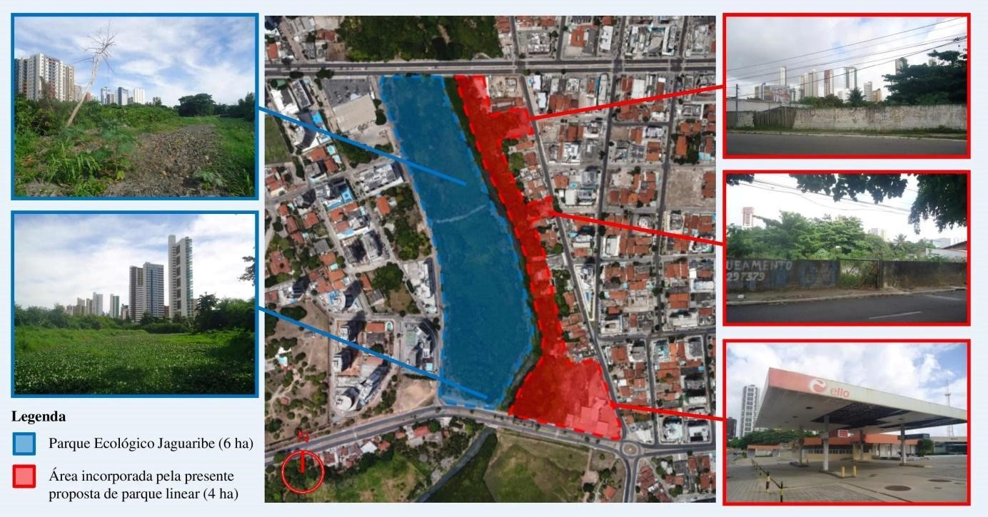
Fig. 2: Scheme of the present proposed linear park in the Jaguaribe River. Source: Google Earth (edited by the author).
2 Spatial analysis
In order to better understand the natural and urban characteristics of the chosen site and its surroundings, we elaborated maps of topography and vegetation cover, road system and public transportation, and land use and occupation. They were based on the online available CAD map by the Municipality of João Pessoa, in the current aerial image by Google Earth and on site visits with the botanists Prof. Dr. Rita Lima and Prof. Carlos Alberto Beltrão, from the Systematics and Ecology Department of the Federal University of Paraíba.
In the elaboration of the maps of the road system and public transport and land use and occupation, a radius of 500 meters was defined, considering the size of the proposed park (10 hectares) and the distance considered comfortable to walk on foot (Gehl, 2013; Yeang, 2013).
2.1. Topography and Vegetation Cover
Examining the topography of the chosen site (Fig. 3), the left bank presents different slopes. In the section near Epitácio Pessoa Avenue, there is a 10-meter difference between Capim Street and the Jaguaribe River, with a gradient of 10%, while the section near Beira Rio Avenue has a 5-meter drop, which inclination varies between 3% and 5%. The right bank, however, presents a homogeneous difference of 3 meters between Paulino Pinto Avenue and the river, which slope varies between 1% and 3%.
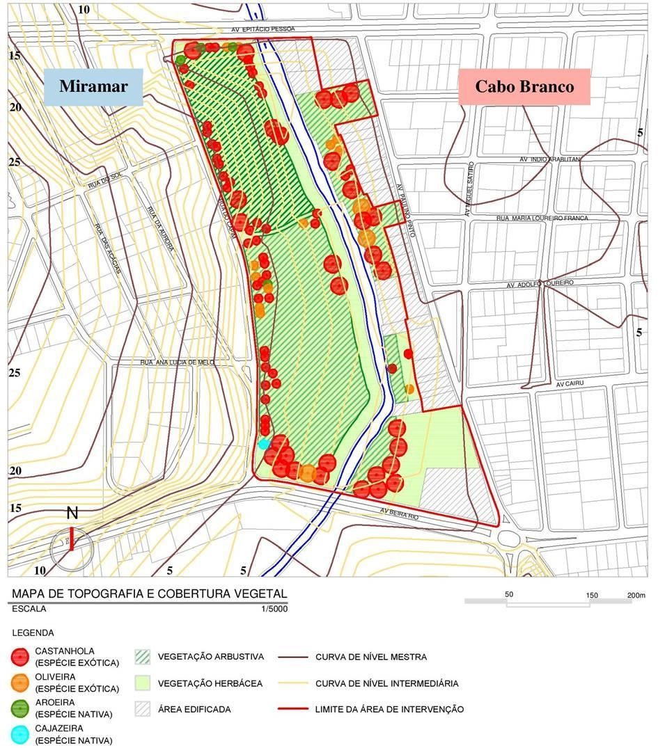
Fig. 3: Map of topography and vegetation cover of the chosen site. Source: Author's collection.
Regarding vegetation cover, a predominance of exotic species, especially "tropical almond trees" (Terminalia catappa), occurs on both banks of the river. On the left bank, although it is totally unoccupied, the vegetation is concentrated along the adjacent roads, with shrub and herbaceous species prevailing, and there are deforested areas at the Permanent Preservation Area (PPA). When it comes to the right bank, it is partially edified, presenting most of its vegetation cover, composed mainly of large and medium-sized species, concentrated near the river, at the PPA.
2.2. Road System and Public Transportation
The chosen site (Fig. 4) is located between two important arterial roads of João Pessoa: Epitácio Pessoa and Beira Rio Avenues. Both connect the city centre to the Seafront, thus presenting a significant flow of people, vehicles and public transportation. Therefore, they would facilitate the displacement between different parts of the city and the proposed park.
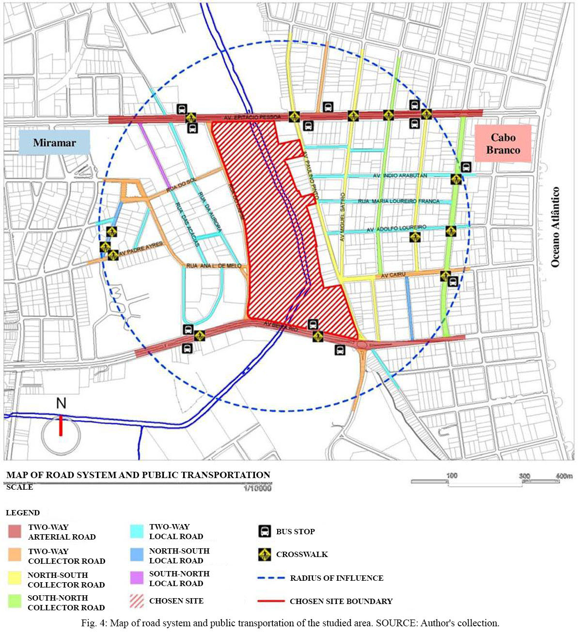
Fig. 4: Map of the road system and public transportation of the studied area. Source: Author's collection.
Capim Street and Paulino Pinto Avenue, adjacent to the chosen site, are also relevant, since they facilitate the connection between neighborhoods of the North Coast, such as Manaíra and Tambaú, and the South Coast, as Altiplano. When it comes to the traffic in the studied area, in Miramar local roads predominate, while Cabo Branco presents a greater number of collector roads, thus providing a more intense flow of vehicles.
2.3. Land Use and Occupation
Despite the predominance of residential use at the studied area (Fig. 5), there are some particularities in each neighborhood. Cabo Branco presents a greater number of stores and services, especially on Marcionila da Conceição Avenue, as well as hotels and inns, while Miramar concentrates a wider variety of educational institutions, from Nurseries to Universities.
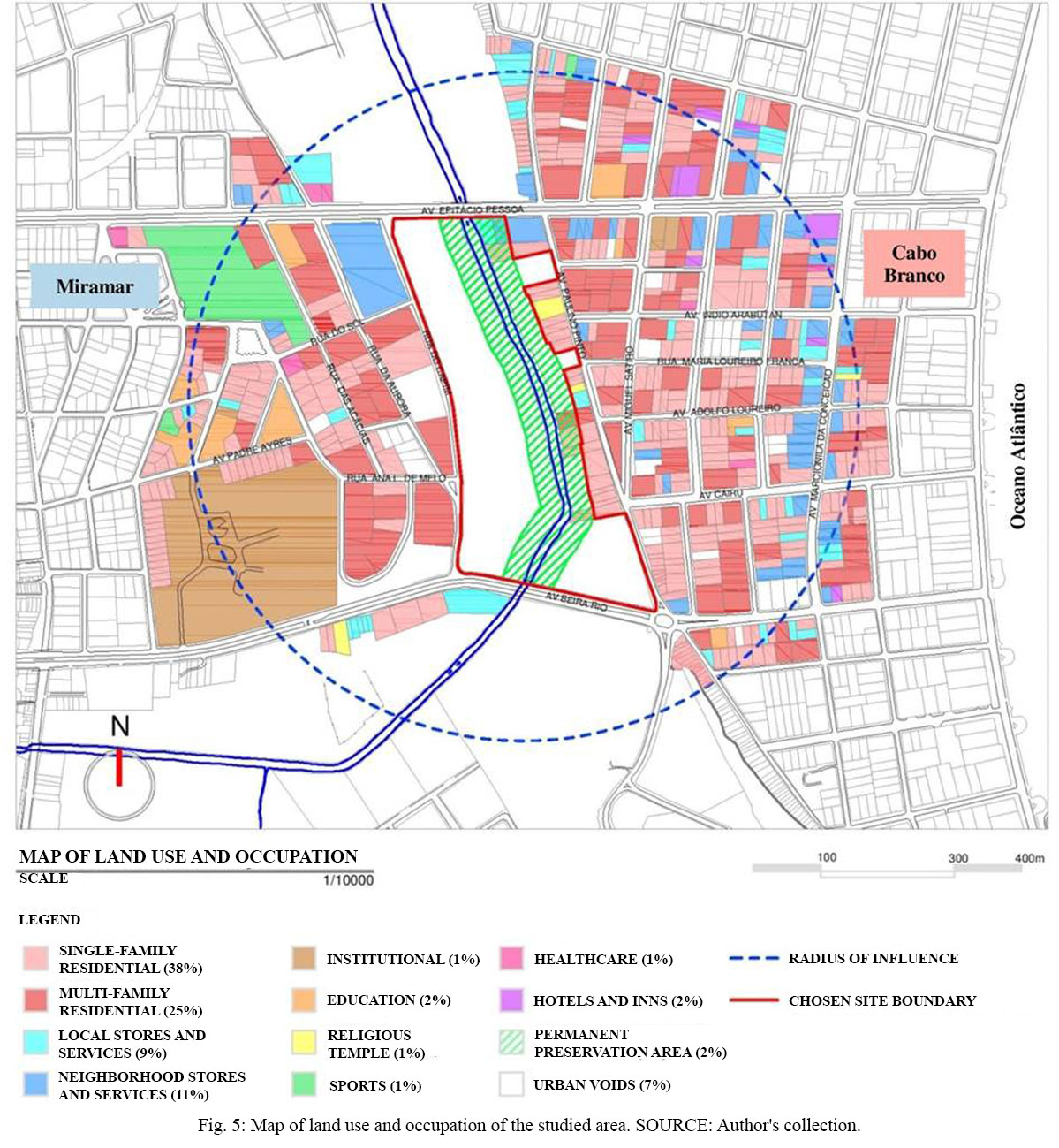
Fig. 5: Map of land use and occupation of the studied area. Source: Author's collection.
This presence of different uses at the studied area, such as stores, educational institutions, health facilities and religious temples, provides different types of users, which is important for the dynamics of the neighborhoods and, consequently, of the proposed park (Jacobs, 2011; Yeang, 2013). In addition, the possibility of connecting regions with distinct and complementary characteristics, such as the case of Miramar and Cabo Branco neighborhoods, is fundamental for the insertion of urban parks (Jacobs, 2011).
Other aspects identified in this area are the small number of public squares, especially in Cabo Branco, which justifies the need for a public leisure space for these neighborhoods; and the presence of urban voids, which allows the appropriation of new uses that meet the demands of the resident population.
Regarding the Permanent Preservation Area (PPA), there are some partial invasions on the right bank, which can be adapted to the legislation without reallocation. Only two stores found on Epitácio Pessoa Avenue ultimately invade the PPA of this bank, but there are several vacant lots in these neighborhoods where they could be relocated, even next to the proposed park, thus allowing people flow and, consequently, mutual support between both uses (Gehl, 2013; Jacobs, 2011).
2.4. Table of problems and potentialities
Based on the presented study, a table of identified problems and potentialities was elaborated (Fig. 6), to guide the proposed linear park in the present work. It was based on the SWOT Analysis methodology; a table used to evaluate scenarios in strategy planning (Yeang, 2013).
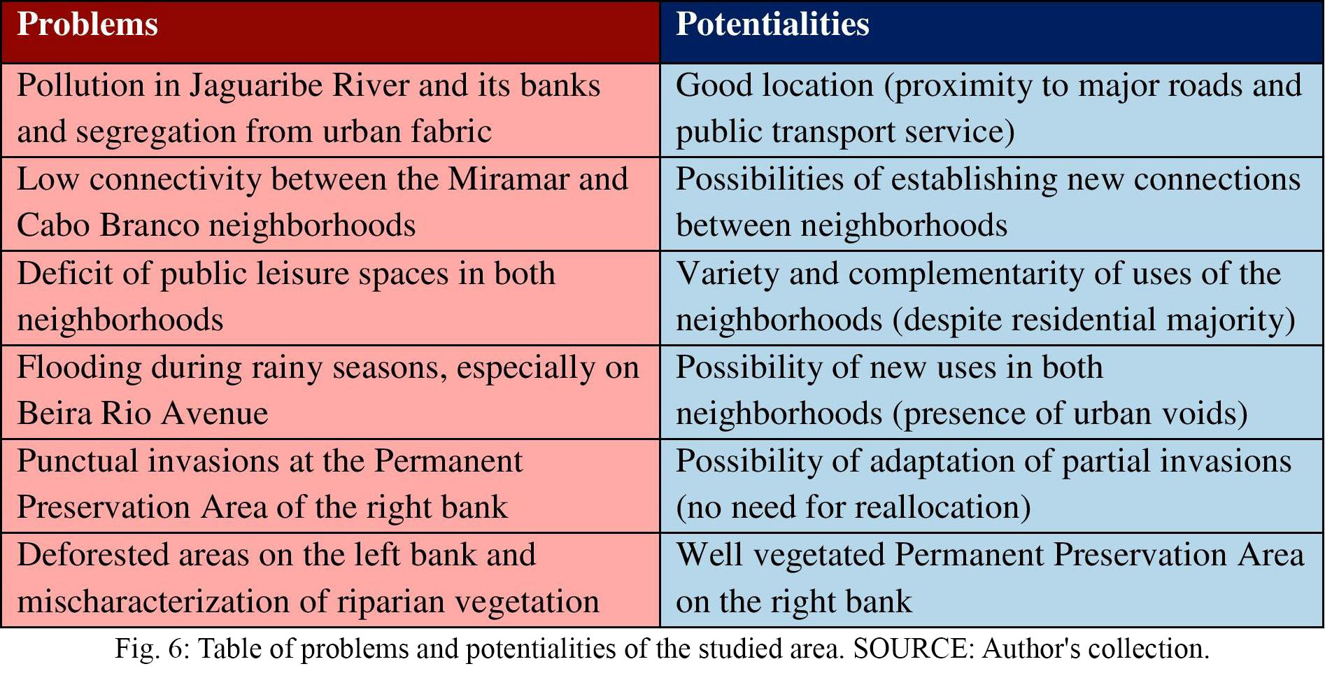
Fig. 6: Table of problems and potentialities of the studied area. Source: Author's collection.
3 PROPOSAL
Based on the spatial analysis of the chosen site and its surroundings, on the identified problems and potentialities and on the solutions and strategies studied in the literature review, the design guidelines (Fig. 7) and zoning (Fig. 8 and 9) were defined for the present proposed linear park in the Jaguaribe River.
3.1. Design guidelines
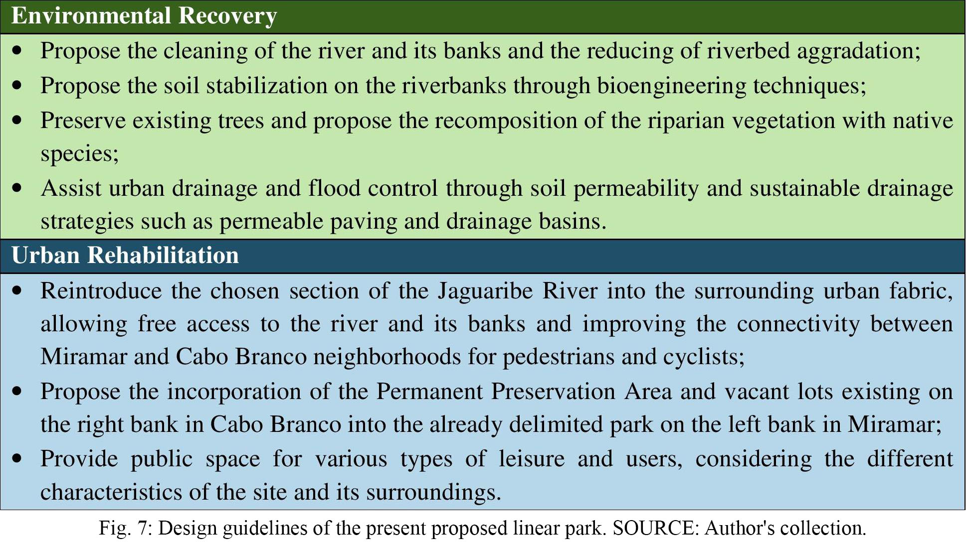
Fig. 7: Design guidelines of the present proposed linear park. Source: Author's collection.
3.2. Zoning
Aiming to provide multifunctionality throughout the park, rest and contemplation areas are proposed near the river, at Permanent Preservation Areas. Also, educational, recreational and gathering areas are located near the streets, aiming to protect the river and to attract the presence and movement of people (Gehl, 2013; Jacobs, 2011; Yeang, 2013).
On the left bank, in the Miramar neighborhood, are proposed areas focused on the contemplation of nature, taking advantage of the greater land slope in the section near Epitácio Pessoa Avenue. In order to involve educational institutions in this neighborhood, educational and cultural activities are also proposed, as well as recreational and outdoor exercise areas, especially in the section with a lower slope near Beira Rio Avenue.
Concerning the right bank, considering the deficit of public leisure spaces for the residents of Cabo Branco, especially for the nearby poor communities, and the propensity of this neighborhood to entertainment and tourism, with several restaurants, bars, hotels, and inns, it is proposed on the corner of Beira Rio and Paulino Pinto Avenues an area for gathering, recreation and sports education, which houses a café and multisport courts.
The entrance squares on Paulino Pinto Avenue, besides allowing new connections between the two neighborhoods through bridges for pedestrians and cyclists, consist of gathering places similar to Pocket Parks, created in the United States and existent in different parts of the world, including Brazil. Regarding the Permanent Preservation Area of the right bank, it is incorporated into the park in order to recover and protect the river and its riparian vegetation, besides becoming part of the park landscape.
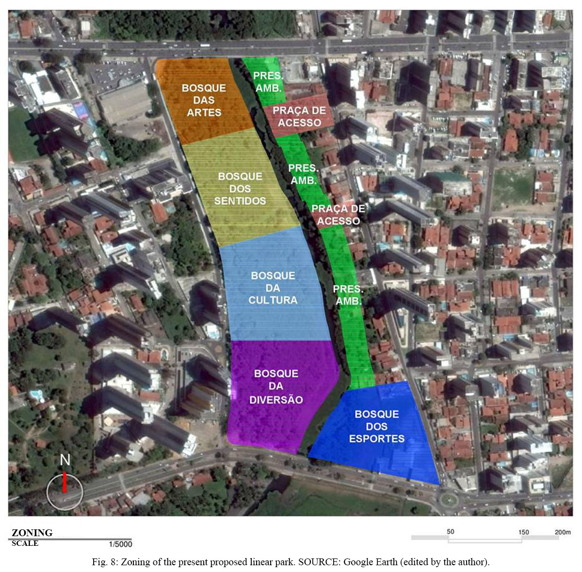
Fig. 8: Zoning of the present proposed linear park. Source: Google Earth (edited by the author).
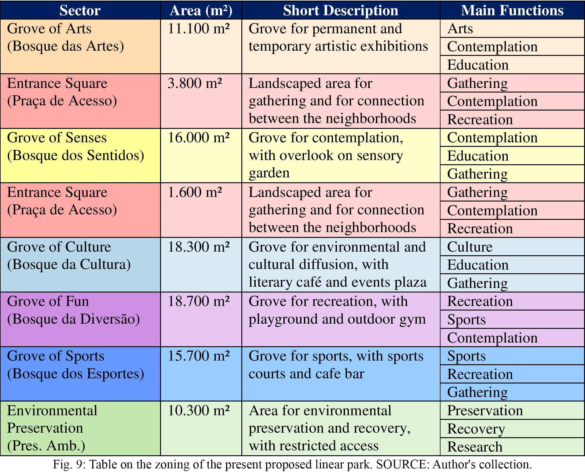
Fig. 9: Table on the zoning of the present proposed linear park. Source: Author's collection.
3.3. Descriptive Memorial
Based on the elaborated guidelines and zoning, the design of the present proposed linear park in the Jaguaribe River was developed (Fig. 10 and 11). The main intention was to preserve and recover the natural environment, for example, protecting the maximum vegetation cover, which is extremely important for the protection of the river and its banks, for drainage and cleaning of soil and water and for the thermal comfort of the population (Gorski, 2010; Hough, 2004; Penteado and Caser, 2005).
The intention was also to implement a public leisure space, taking advantage of the peculiarities of the site to provide different uses and ambiances and establishing clear and objective connections from the existing urban fabric, in order to allow free access and movement of the population (Jacobs, 2011; Yeang, 2013).
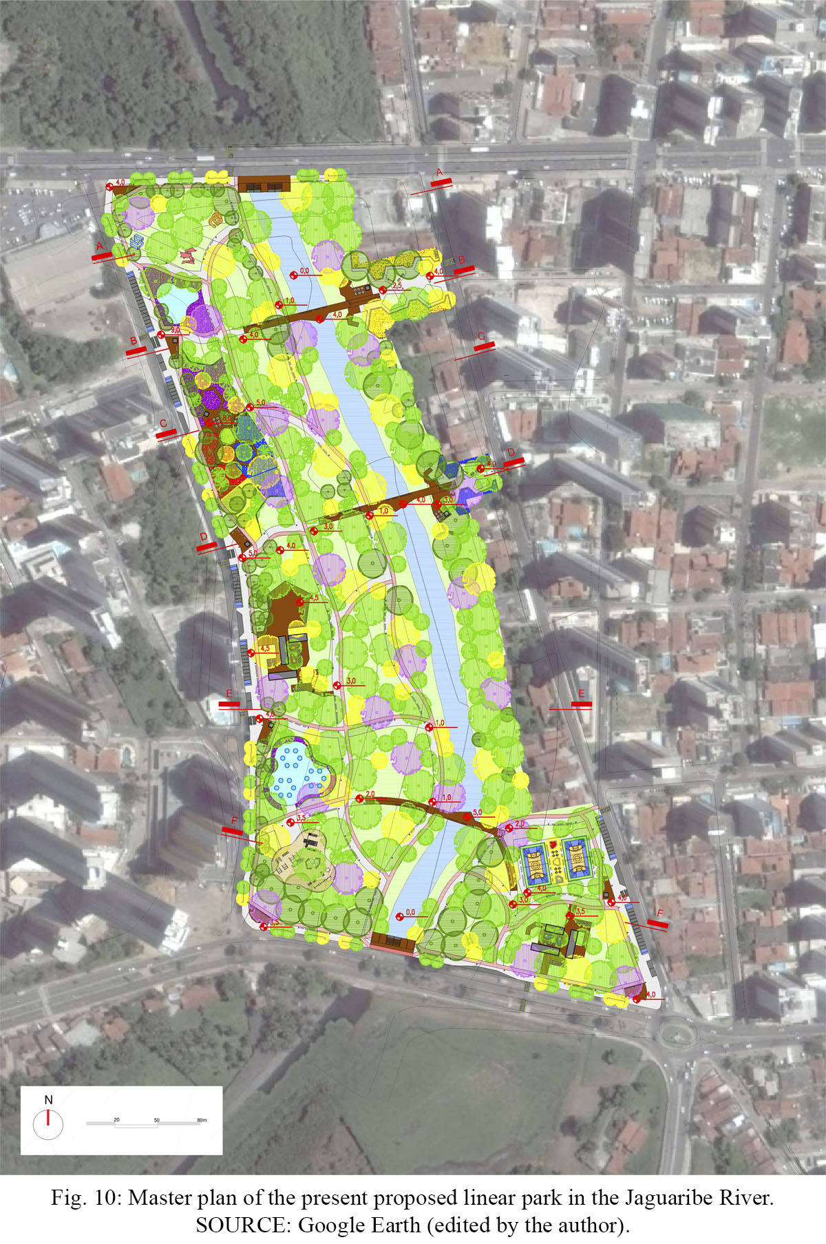
Fig. 10: Master plan of the present proposed linear park in the Jaguaribe River. Source: Google Earth (edited by the author).
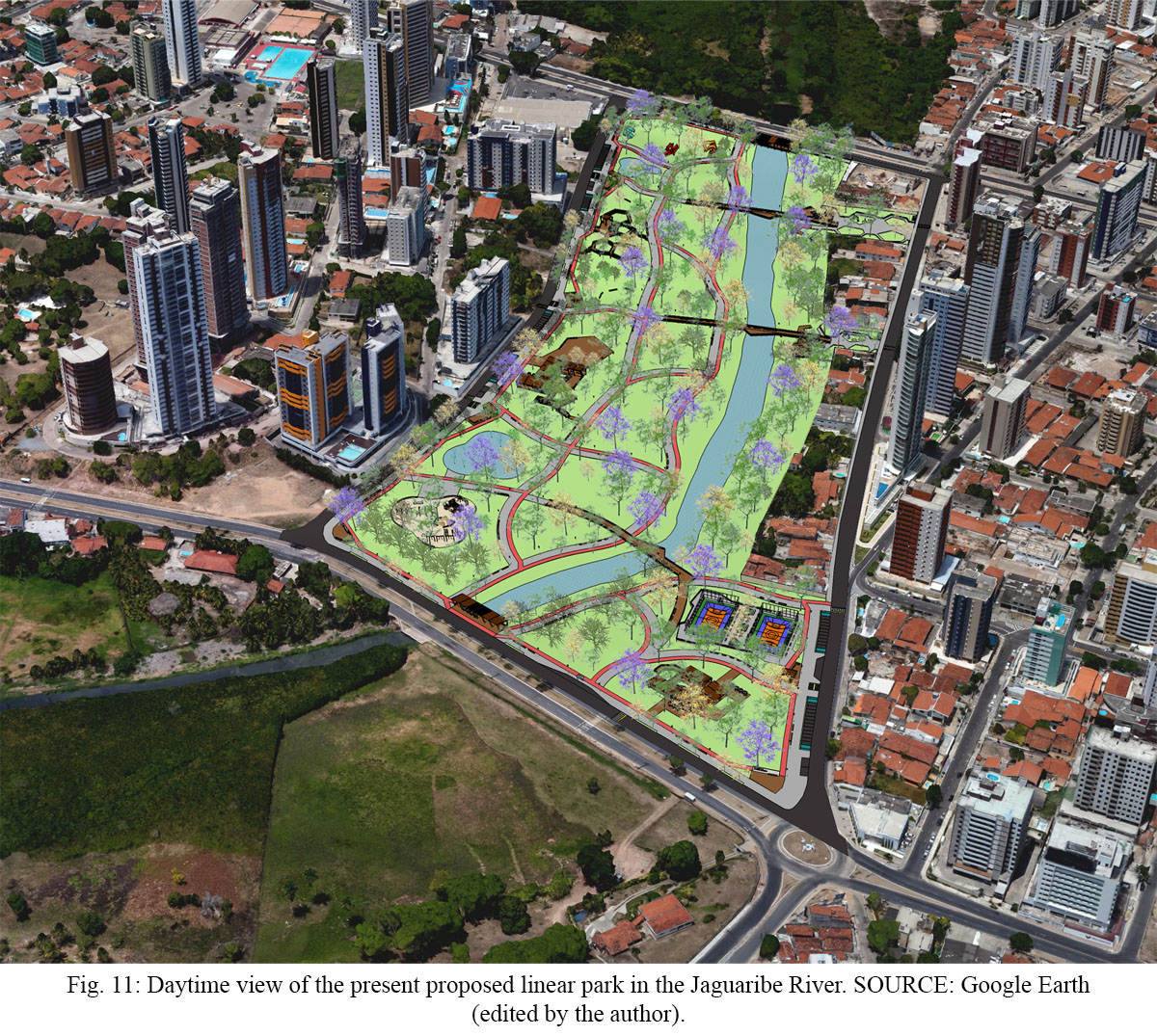
Fig. 11: Daytime view of the present proposed linear park in the Jaguaribe River. Source: Google Earth (edited by the author).
The paths design had as primary reference the sinuosity of nature, mainly of the river course. Regarding the proposed elevated bridges, they aim to make it possible to contemplate the landscape and cross the banks during the whole year, even in periods of greater precipitation, when the level of the river rises.
The proposed buildings throughout the park will be prefabricated modular constructions, aiming at lower impacts to the fluvial environment and greater versatility of uses. Concerning the bridges and decks, although they appear to be made of wood in reference to the surrounding nature, they will consist of a metal structure with a wooden-plastic (WPC) floor, which are recyclable materials and more resistant to environmental factors.
Regarding the flows and road system of the present project (Fig. 12), proposed paths can be classified into four types, according to their location: perimeter paths, which allow walking through the park surroundings and the river's edge; center paths, which run through the park; transversal paths, which allow access to the river and/or cross between the banks; and secondary paths, which act as shortcuts, interconnecting the other paths.
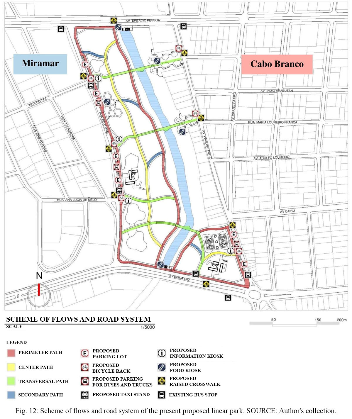
Fig. 12: Scheme of flows and road system of the present proposed linear park. Source: Author's collection.
Parking lots are proposed near corners, and park accesses to facilitate the circulation of vehicles and their users, being located only on Capim Street and Paulino Pinto Avenue in order to avoid significant impacts on the intense traffic on Epitácio Pessoa and Beira Rio Avenues. Near the park accesses, information and food kiosks are also proposed, aiming, in addition to providing services to the population, to attract people and to stimulate natural surveillance in these places (Jacobs, 2011; Yeang, 2013).
Concerning soil permeability (Fig. 13), the present proposal presents a large extension of permeable areas, occupying 64% of the proposed park. With the permeable paving suggested for sidewalks and parking lots, it is possible to establish 28% of semipermeable surfaces, leaving only 8% of impervious areas. It is important to note that although proposed bridges and decks are impermeable surfaces since they are raised above the ground, they will not compromise water infiltration at these sites.
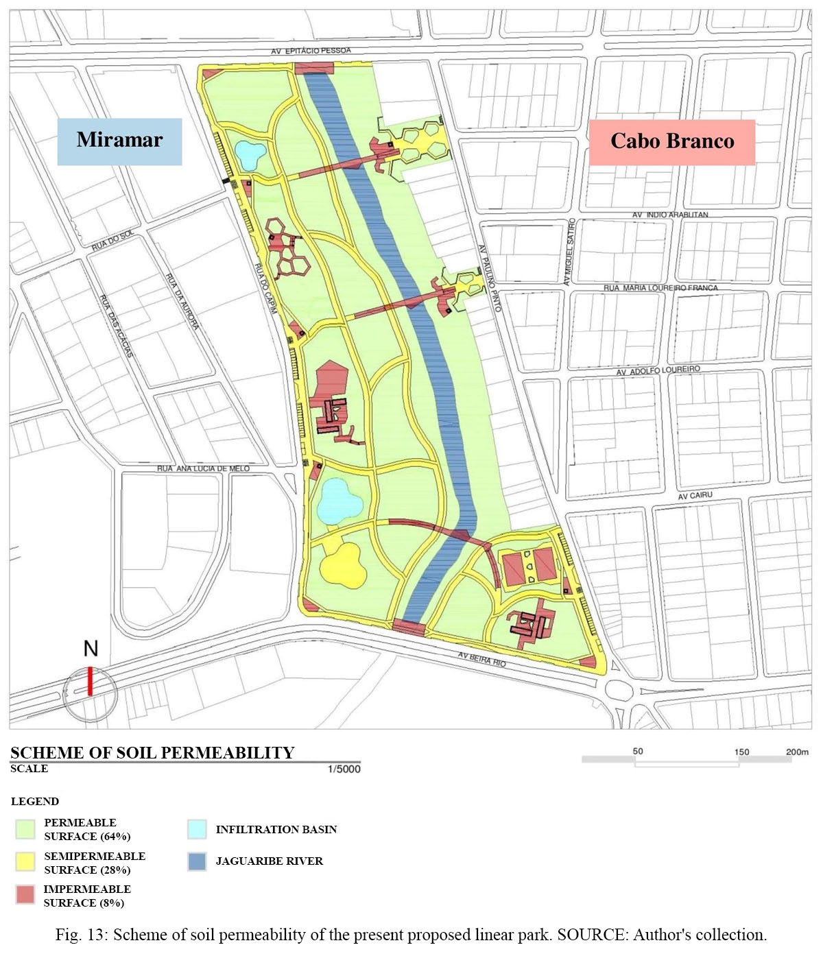
Fig. 13: Scheme of soil permeability of the present proposed linear park. Source: Author's collection.
Concerning the proposed landscaping (Fig. 14), besides the recomposition of riparian vegetation, the suggested species also meet specific objectives: large and medium trees for shading; fruit trees and ornamental plants as sensory elements, especially in the Groves of Senses and of Fun; and aquatic plants for the treatment of the rainwater flow in the proposed infiltration basins.
It is important to point out that, for the recomposition of riparian vegetation, a wide diversity of native plant species and more detailed studies on the site are necessary, in partnership with other professionals, such as biologists and environmental engineers.
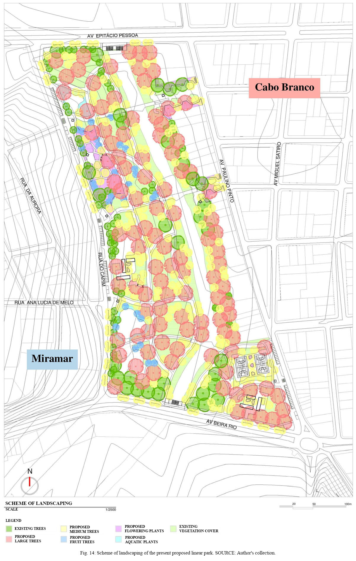
Fig. 14: Scheme of landscaping of the present proposed linear park. Source: Author's collection.
About the lighting (Fig. 15 and 16), 5 meter high LED luminaires are spaced every 20 meters along the sidewalks, aiming to assist in nighttime safety and to highlight the existing paths in the park (Gehl, 2013). Other LED lighting elements are proposed to reinforce the nighttime illumination, in addition to providing landscaping effects, especially in the Grove of Fun, under the overlook in the Grove of Senses and the elevated bridges.
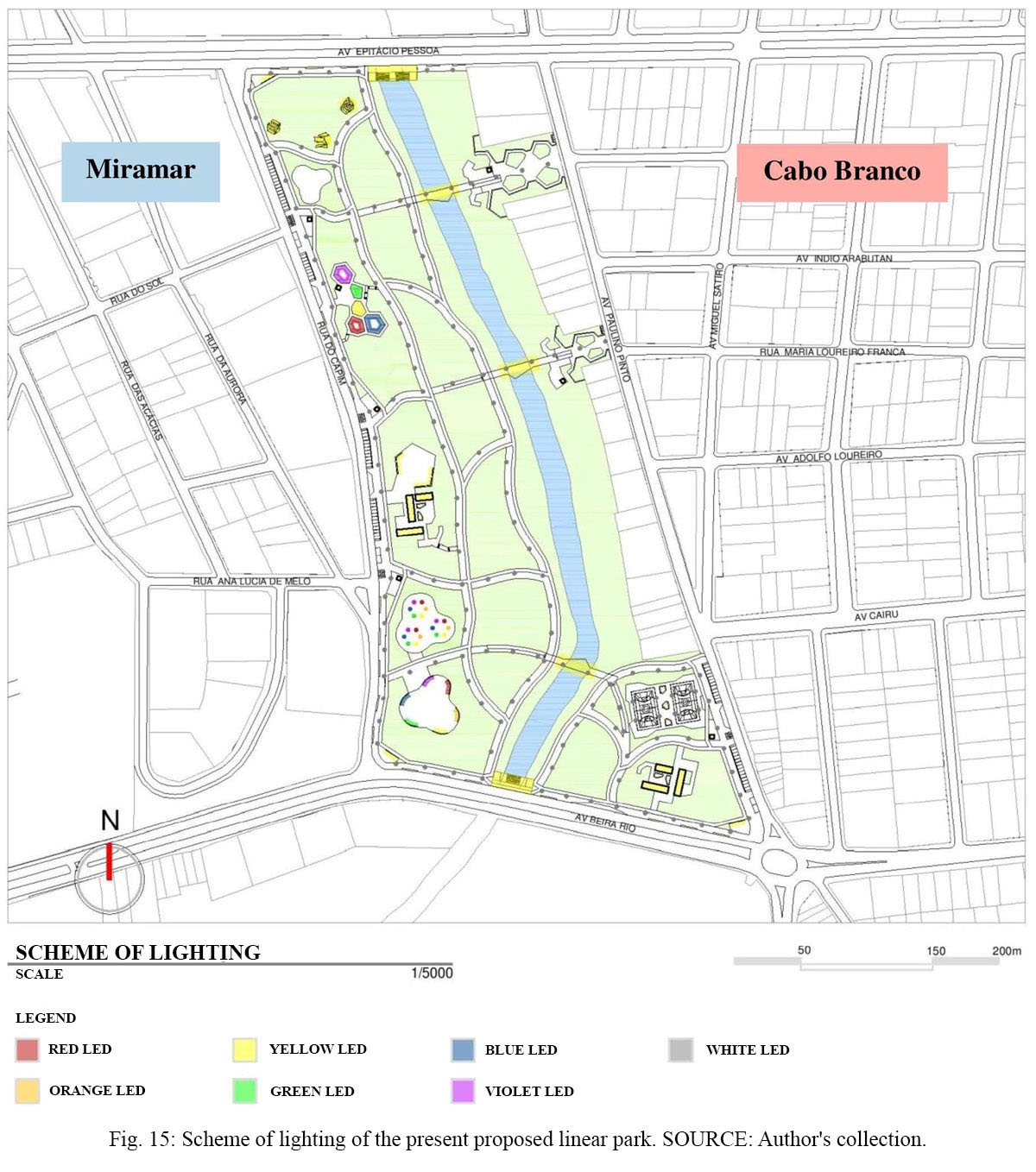
Fig. 15: Scheme of lighting of the present proposed linear park. Source: Author's collection.
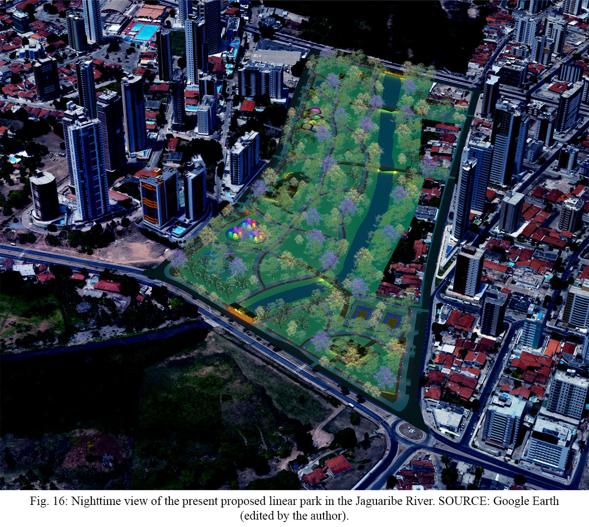
Fig. 16: Nighttime view of the present proposed linear park in the Jaguaribe River. Source: Google Earth (edited by the author).
3.3.1. Grove of Arts
Grove of Arts (Fig. 17) consists of an area dedicated to permanent and temporary exhibitions of works of art, aiming to promote mainly local artists, similar to that intended by Municipal Law No. 5738/1988 on the mandatory presence of works of art in buildings. Due to its location, next to Epitácio Pessoa Avenue, one of the best known and frequented avenues in the city, these works of art can play a significant role as visual landmarks for the proposed park, attracting attention and presence of people.
Fig. 17: View of the Grove of Arts. Source: Author's collection.
Close to this park sector, there are several educational institutions, including on Epitácio Pessoa Avenue, which can collaborate in the educational role and the cultural and artistic diffusion proposed for this area, through periodic visits and also exhibitions held by their students.
To minimize possible flooding of the Jaguaribe River, an infiltration basin is also proposed in this sector, mainly due to the rainwater flow from Sol Street, a perpendicular street to the park. Aiming at the treatment of the rainwater flow, a biological filter made up of aquatic plants and layers of rock and sand is proposed in the basin.
3.3.2. Grove of Senses
In the Grove of Senses (Fig. 18), an overlook is proposed on a garden with native ornamental species and fruit trees, taking advantage of the accentuated slope of this site section to allow the contemplation of the river and the park.
This is a space dedicated especially to playful and educational activities, involving different sensorial perceptions, through the different colors, shapes, textures, and scents of the vegetation, the varied flavors of the local fruits available and the distinct sounds of the surrounding nature, such as the river running water and animals, mainly birds.
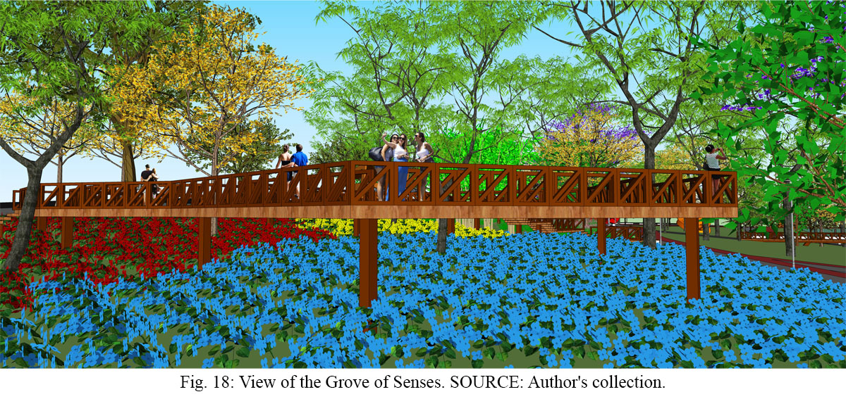
Fig. 18: View of the Grove of Senses. Source: Author's collection.
3.3.3. Entrance Squares
The entrance squares proposed on the right bank of the Jaguaribe River (Fig. 18) consist of gathering places inspired by the Pocket Parks, taking advantage of the vacant lots currently existing as small public leisure spaces. Through elevated bridges for pedestrians and cyclists, these squares will also enable new connections between Cabo Branco and Miramar neighborhoods.
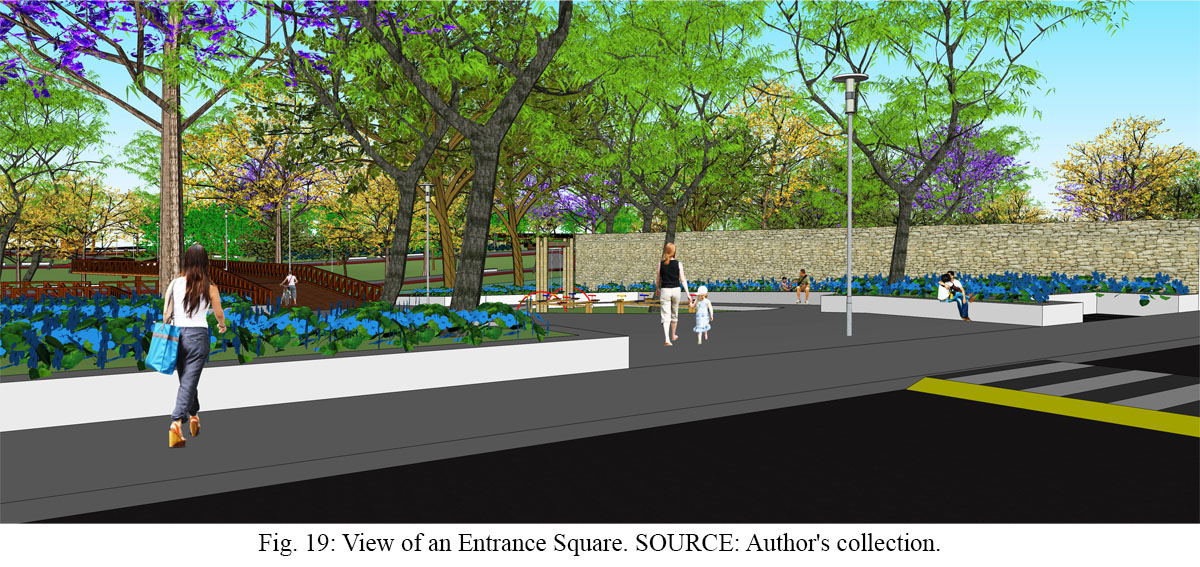
Fig. 19: View of an Entrance Square. Source: Author's collection.
In the perimeter of the squares, flower beds are proposed which, besides being a landscape element, serve as urban furniture, constituting a continuous seat, and as a physical barrier between the public and private spaces, protecting the neighboring lots. In order to stimulate the constant presence of people and, consequently, natural vigilance, food kiosks and recreational equipment are also proposed in these squares.
3.3.4. Grove of Culture
Grove of Culture (Fig. 20) consists of an area dedicated to environmental education and cultural diffusion, mainly aimed to attract nearby educational institutions. Taking advantage of the low slope of this site section, it is proposed a gathering deck housing a literary café, an environmental education center, public toilets and an events plaza.
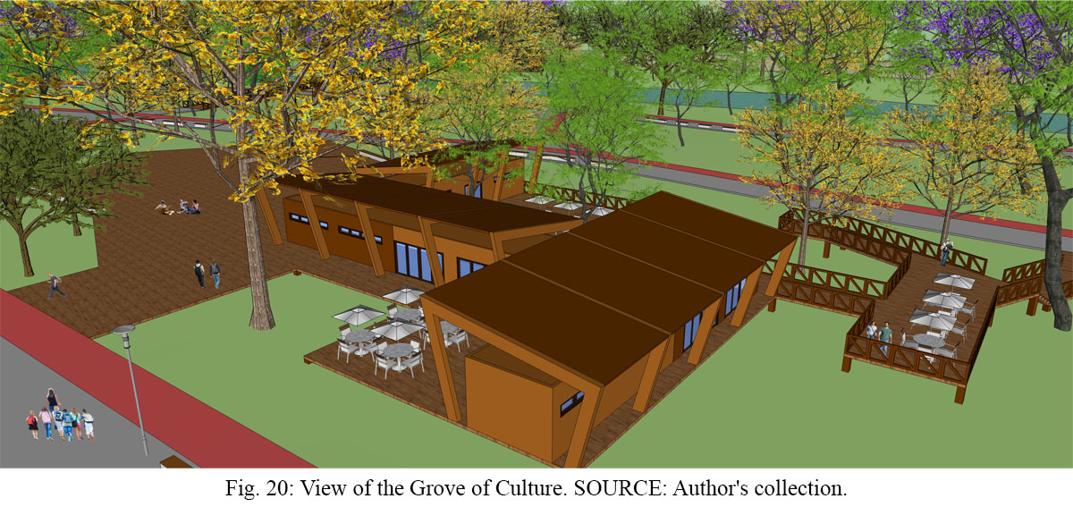
Fig. 20: View of the Grove of Culture. Source: Author's collection.
Inspired by the literary cafés at the urban parks in Santiago, Chile, the proposed café incorporates the educational aspect of this sector of the park into its usual activities, thus becoming a place for reading and cultural diffusion, as well as for eating and gathering.
The environmental education center has as main objective to promote different educational activities, such as lectures, workshops and guided tours for park visitors, mainly students.
Regarding the events plaza, it is a multifunctional space for leisure and gathering, with a maximum capacity of 1,500 people (considering three people per square meter). Its main purpose is to accommodate educational and cultural activities in the open air, such as small fairs and local festivities, which may result from partnerships with schools, religious temples and other nearby institutions, as well as the public administration itself.
3.3.5. Grove of Fun
Grove of Fun (Fig. 21) consists of a recreational space for all ages, with playground and outdoor gym, aiming to minimize the shortage of public squares for residents of Miramar, especially for needy communities in the neighborhood. It will also be able to meet the needs of nearby schools, especially two children's schools that connect directly with this sector through a street perpendicular to the park, Ana Lucia de Melo Street.
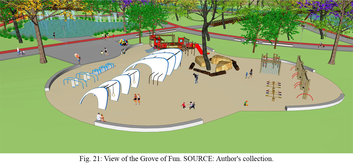
Fig. 21: View of the Grove of Fun. Source: Author's collection.
Due to the rainwater flow from this perpendicular street, as well as from Capim Street, an infiltration basin is also proposed in this sector to minimize possible floods, by using the same water treatment system proposed in the Grove of Arts.
3.3.6. Grove of Sports
The Grove of Sports (Fig. 22) consists of a recreation and gathering place, aiming mainly to minimize the public squares deficit in the Cabo Branco neighborhood. Multisport courts, cafe bar, public restrooms and a sports education center are proposed, which purpose is to promote different recreational activities, such as soccer, basketball, martial arts, capoeira, dance and yoga, especially for nearby needy communities.
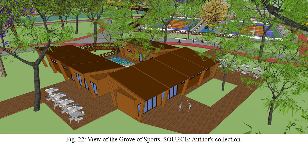
Fig. 22: View of the Grove of Sports. Source: Author's collection.
Regarding the cafe bar, besides serving as a place for eating and gathering, it can play an important role as an attraction for the proposed park, considering the propensity of the Cabo Branco neighborhood to entertainment and tourism, with a variety of restaurants, bars, hotels and inns.
4 Final considerations
Considering the study carried out on the theme and the chosen site, we conclude that the present work achieved its primary objective: to propose a linear park that could help the recovery of the Jaguaribe River, improve the connectivity between the Miramar and Cabo Branco neighborhoods and offer a public leisure space for the population of João Pessoa city.
The local government initiative to create the Jaguaribe Ecological Park aiming to protect the chosen site was important, but perhaps due to the absence of previous studies, it failed by including only one riverbank and because "ecological park" is not a classification defined by the Municipal System of Protected Areas (MSPA). Therefore, it is understood that the present proposed linear park, including both riverbanks as defined by the MSPA, will enable the chosen site to better play its environmental, urban and social functions.
It is important to emphasize that the process of intervention in urban rivers should cover its entire river basin. Public competition for projects, popular participation and the joint work of different professionals such as architects, engineers, biologists, and ecologists are therefore necessary and enriching. In this context, it is concluded that linear parks, as proposed by the present work, are essential tools in the recovery and reintegration of urban rivers into the cities fabric as gathering places, being thus extremely relevant to the theme “Weaving the city” of the V!RUS journal current issue.
References
Almeida, J. R., Araujo, G. H. S. and Guerra, A. J. T., 2005. Gestão Ambiental de Áreas Degradadas. Rio de Janeiro: Bertrand Brasil.
Brazil, 2012. Lei nº 12.651, de 25 de maio de 2012. Novo Código Florestal. Brasília.
Cengiz, B., 2013. Urban River Landscapes. In: M. Ozyayuz, Ed. 2013. Advances in Landscape Architecture. Rijeka: InTech. pp.551-586. Available at: <http://www.intechopen.com/books/advances-in-landscape-architecture/urban-river-landscapes> [Accessed 09 January 2015].
Dieb, M. A., 2013. Cerzindo rios e cidades: perspectivas para o resgate da bacia do Rio Jaguaribe - João Pessoa/PB. Rio de Janeiro: Universidade Federal do Rio de Janeiro.
Friedrich, D., 2007. O parque linear como instrumento de planejamento e gestão das áreas de fundo de vale urbanas. Porto Alegre: Universidade Federal do Rio Grande do Sul.
Gehl, J., 2013. Cidades para Pessoas. São Paulo: Perspectiva.
Gorski, M. C. B., 2010. Rios e Cidades: Ruptura e Reconciliação. São Paulo: Editora Senac São Paulo.
Hough, M., 2004. Naturaleza y Ciudad. Barcelona: Editorial Gustavo Gili.
Jacobs, J., 2011. Morte e Vida de Grandes Cidades. São Paulo: Editora WMF Martins Fontes.
Penteado, H. M. and Caser, K. C., 2005. Ecologia da Paisagem em Projetos de Orlas Fluviais Urbanas. In: 1st Semináro Nacional sobre Regeneração Ambiental de Cidades. Rio de Janeiro: Universidade Federal do Rio de Janeiro.
Prefeitura Municipal de João Pessoa, 2010. Secretaria Municipal de Meio Ambiente. Diagnóstico Ambiental Simplificado das Condições Geoambientais do Baixo Jaguaribe, no trecho entre as Avenidas José Américo de Almeida e Ruy Carneiro, João Pessoa – PB. João Pessoa: [s.n.].
Prefeitura Municipal de João Pessoa, 2011. Lei nº 12.101, de 30 de junho de 2011. Sistema Municipal de Áreas Protegidas de João Pessoa. João Pessoa.
Prefeitura Municipal de João Pessoa, 2012. Plano Municipal de Conservação e Recuperação da Mata Atlântica. João Pessoa: F&A Gráfica e Editora.
Sanches, P. M., 2007. O papel dos rios na cidade contemporânea: dimensão social e ecológica. In: APPURBANA, Seminário Nacional sobre o Tratamento de Áreas de Preservação Permanente em Meio Urbano e Restrições ao Parcelamento do Solo. São Paulo: FAU USP.
Silva, L. M. T., 2012. Espaços Verdes em João Pessoa: Planejamento e Realidade. João Pessoa: Universidade Federal da Paraíba. 2012. Available at: <http://www.ligiatavares.com/index.php?secao=artigo&id=7> [Accessed 08 April 2015].
Timur, U. P., 2013. Urban Waterfront Regenerations. In: M. Ozyayuz, Ed. 2013. Advances in Landscape Architecture. Rijeka: InTech. pp.169-206. Available at: <http://www.intechopen.com/books/advances-in-landscape-architecture/urban-river-landscapes> [Accessed 09 January 2015].
Yeang, L. D., 2013. Urban Design Compendium. London: English Parterships. Available at: <http://udc.homesandcommunities.co.uk/urban-design-compendium> [Accessed 29 May 2015].